Area Overview for CV3 1FB
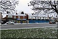
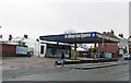
Photos of CV3 1FB


Area Information
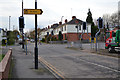
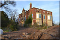
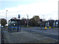
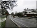
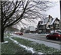
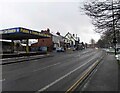
CV3 1FB is a compact residential postcode in England’s West Midlands, nestled within Coventry’s Lower Stoke Ward. Covering just 4,534 square metres, it is densely populated, with 1,388 residents living at a density of 306,160 people per square kilometre. This small area straddles the Coventry-Rugby railway line, blending newer housing developments with remnants of 20th-century industrial activity. The community is defined by its proximity to Coventry’s city centre, with the area historically shaped by car manufacturing and light industry. Today, it offers a mix of residential and commercial spaces, with housing concentrated north of the railway line. Daily life here is characterised by easy access to rail links, nearby retail, and a relatively young population. While the area lacks historic landmarks, its practical layout and connectivity to Coventry’s infrastructure make it a pragmatic choice for those prioritising convenience over heritage. The low crime rate and flood risk further enhance its appeal for families and professionals seeking a compact, functional living environment.
- Area Type
- Postcode
- Area Size
- 4534 m²
- Population
- 1388
- Population Density
- 2853 people/km²
The property market in CV3 1FB is dominated by houses, with 49% of residents owning their homes and the remainder likely renting. This suggests a balance between owner-occupied and rental properties, though the low home ownership rate indicates a strong presence of private landlords or housing associations. The area’s compact size means housing stock is limited, with developments concentrated north of the Coventry-Rugby railway line, replacing former industrial sites. The prevalence of houses over flats may appeal to families or those seeking more space, but the small area’s boundaries mean buyers must consider nearby suburbs for additional options. The industrial legacy of the area, including former car factories and light industry, has shaped the layout of housing, with newer developments prioritising practicality over architectural distinction. For buyers, the market is likely competitive, with limited inventory and proximity to Coventry’s amenities offering key advantages.
House Prices in CV3 1FB
Showing 17 properties
| Address | Type | Beds | Baths | Last Sale Price | Last Sale Date | |
|---|---|---|---|---|---|---|
| 287 Whitworth Avenue, Coventry, CV3 1FB | Terraced | 3 | 1 | £120,500 | Nov 2021 | |
| 285 Whitworth Avenue, Coventry, CV3 1FB | Terraced | 3 | 1 | £120,000 | Jun 2016 | |
| 273 Whitworth Avenue, Coventry, CV3 1FB | Flat | - | - | - | - | |
| 271 Whitworth Avenue, Coventry, CV3 1FB | Flat | - | - | - | - | |
| 299 Whitworth Avenue, Coventry, CV3 1FB | house | - | - | - | - | |
| 289 Whitworth Avenue, Coventry, CV3 1FB | house | - | - | - | - | |
| 279 Whitworth Avenue, Coventry, CV3 1FB | house | - | - | - | - | |
| 301 Whitworth Avenue, Coventry, CV3 1FB | house | - | - | - | - | |
| 303 Whitworth Avenue, Coventry, CV3 1FB | house | - | - | - | - | |
| 281 Whitworth Avenue, Coventry, CV3 1FB | house | - | - | - | - |
Energy Efficiency in CV3 1FB
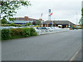
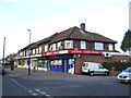
Living in CV3 1FB offers access to a range of nearby amenities within practical reach. Retail options include Budgens Aldermoor, Lidl Upper, and Iceland Binley, providing everyday shopping convenience. The area’s rail network, with stations such as Canley and Tile Hill, connects residents to Coventry’s cultural and commercial centres. While the postcode lacks parks or recreational spaces, its proximity to Coventry’s broader infrastructure means residents can access green spaces and leisure facilities in the city. The industrial heritage of the area is evident in its landscape, but the presence of shops, transport links, and proximity to Coventry Airport ensures a functional daily life. The mix of retail, rail, and airport access makes CV3 1FB suitable for those prioritising practicality over expansive leisure options.
Amenities
Schools
| Rank | School | Type | Entry gender | Ages |
|---|
Explore more schools in this area
Go to Schools tabDemographics
The population of CV3 1FB has a median age of 22, though the most common age range is 30–64 years, suggesting a mix of young professionals and established families. Home ownership is relatively low at 49%, indicating a rental market that dominates the area. The accommodation type is primarily houses, reflecting a preference for standalone properties over flats. The predominant ethnic group is White, with no data provided on other demographics. The high population density—306,160 people per square kilometre—means the area is intensely populated despite its small size. This density may influence community dynamics, potentially creating a tight-knit environment but also placing pressure on local amenities. The age profile hints at a workforce-oriented population, with opportunities in nearby industrial and office sectors. However, the lack of specific data on deprivation or income levels means the quality of life for lower-income residents remains unquantified.
Household Size
Accommodation Type
Tenure
Ethnic Group
Religion
Household Composition
Age
Household Deprivation
NS-SEC
Explore more demographic insights in this area
Go to Demographics tabPlanning
Planning Constraints
- Flood RiskPremium
- Ramsar Wetland SitesPremium
- Area of Outstanding Natural BeautyPremium
- Protected Nature ReservePremium
- Protected WoodlandPremium