Area Overview for BB12 8AF
Photos of BB12 8AF

Area Information
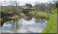
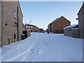
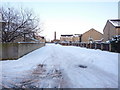
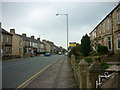
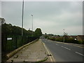
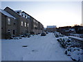
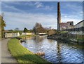
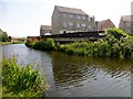
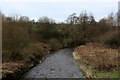
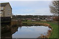
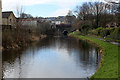
Living in BB12 8AF means inhabiting a compact, residential cluster in the Borough of Burnley, Lancashire. This postcode area, spanning 8,190 square metres, is home to 1,411 people, making it one of the most densely populated regions in England, with 172,289 people per square kilometre. Its location north of Burnley town centre places it near the Leeds and Liverpool Canal, a historic waterway that once spurred industrial activity at Gannow Wharf. The area is bordered by the M65 motorway, which separates it from northern districts. BB12 8AF blends modern housing with remnants of its industrial past, such as Gannow Business Park, where Victorian cotton mills have been repurposed for contemporary use. The community is characterised by a mix of older residents and families, with a median age of 47 and a strong presence of adults aged 30–64. Daily life here is shaped by proximity to rail links, retail hubs, and the canals, offering a blend of convenience and historical context for residents.
- Area Type
- Postcode
- Area Size
- 8190 m²
- Population
- 1411
- Population Density
- 6417 people/km²
The property market in BB12 8AF is largely defined by its high home ownership rate of 64%, indicating that most residents are homeowners rather than renters. The area is predominantly composed of houses, which is unusual in many urban settings where flats or apartments predominate. This suggests a focus on single-family dwellings, likely appealing to those seeking space and stability. Given the area’s small size and high population density, the housing stock is limited, and buyers may need to consider nearby districts for additional options. The presence of Gannow Business Park, with its repurposed Victorian mills, adds a unique element to the local property landscape, though it is more focused on commercial use than residential development. For buyers, this means a relatively static market with limited new construction, making existing properties the primary focus. The compact nature of the area also means that proximity to amenities and transport is a key selling point, as residents benefit from being close to rail links and retail hubs.
House Prices in BB12 8AF
Showing 17 properties
| Address | Type | Beds | Baths | Last Sale Price | Last Sale Date | |
|---|---|---|---|---|---|---|
| 3 Romford Street, Burnley, BB12 8AF | Terraced | 2 | 1 | £139,995 | Jul 2025 | |
| 7 Romford Street, Burnley, BB12 8AF | Terraced | 3 | 1 | £113,000 | Jan 2024 | |
| 13 Romford Street, Burnley, BB12 8AF | Terraced | 3 | 1 | £155,000 | Oct 2023 | |
| 6 Romford Street, Burnley, BB12 8AF | house | - | - | £90,000 | Sep 2021 | |
| 11 Romford Street, Burnley, BB12 8AF | Terraced | 3 | 1 | £124,000 | Jun 2020 | |
| 10 Romford Street, Burnley, BB12 8AF | Terraced | 4 | 1 | £75,000 | Mar 2016 | |
| 15 Romford Street, Burnley, BB12 8AF | Terraced | 2 | 1 | £118,950 | May 2007 | |
| 8 Romford Street, Burnley, BB12 8AF | Terraced | 3 | 1 | £37,200 | Apr 2006 | |
| 1 Romford Street, Burnley, BB12 8AF | Terraced | 3 | 1 | £75,000 | Mar 2006 | |
| 5 Romford Street, Burnley, BB12 8AF | house | - | - | £93,000 | Aug 2005 |
Energy Efficiency in BB12 8AF
Residents of BB12 8AF have access to a range of practical amenities within easy reach. The area’s retail options include Spar and Farmfoods Rosehill, providing essential shopping needs. Nearby rail stations such as Burnley Barracks and Rose Grove offer convenient transport links to Burnley and surrounding areas. The Gannow Community Centre, acquired in 2017, serves as a local hub for social and community activities, enhancing the area’s sense of cohesion. While there are no parks or leisure facilities explicitly listed, the proximity to the Leeds and Liverpool Canal offers opportunities for walking or leisurely activities along the waterway. The Gannow Business Park, with its repurposed Victorian mills, adds a unique character to the area, blending historical architecture with modern commercial use. This mix of practical amenities and historical features contributes to a lifestyle that balances convenience with a connection to the region’s industrial heritage.
Amenities
Schools
The nearest school to BB12 8AF is Whittlefield Primary School, which holds a Good Ofsted rating. This primary school serves the local community, providing education for younger children in the area. The absence of secondary schools in the immediate vicinity means families may need to look further afield for secondary education, though the proximity to Burnley town centre suggests access to larger educational institutions nearby. The presence of a well-rated primary school is a significant advantage for families with young children, offering a reliable foundation for early education. However, the lack of a diverse range of school types, such as secondary or specialist institutions, may require additional planning for students progressing beyond primary level. The school’s rating indicates a satisfactory standard of teaching and facilities, though parents should consider broader educational options beyond the immediate postcode area.
| Rank | School | Type | Entry gender | Ages |
|---|
Explore more schools in this area
Go to Schools tabDemographics
The population of BB12 8AF is 1,411, with a median age of 47 and the majority of residents aged between 30 and 64. This suggests a community of established adults, many of whom may be in their peak working years. Home ownership is high at 64%, indicating a stable, long-term resident base. The area is predominantly composed of houses, which aligns with the demographic profile of older, family-oriented households. The predominant ethnic group is White, reflecting the broader demographic trends in Burnley. The high population density of 172,289 people per square kilometre implies a compact, closely knit community, though it may also mean limited space for expansion. This density can influence local amenities and services, ensuring they are tailored to a concentrated population. The age profile suggests a balance between working professionals and retirees, with fewer young families compared to areas with a higher proportion of younger residents.
Household Size
Accommodation Type
Tenure
Ethnic Group
Religion
Household Composition
Age
Household Deprivation
NS-SEC
Explore more demographic insights in this area
Go to Demographics tabPlanning
Planning Constraints
- Flood RiskPremium
- Ramsar Wetland SitesPremium
- Area of Outstanding Natural BeautyPremium
- Protected Nature ReservePremium
- Protected WoodlandPremium