Area Overview for BB12 8AG
Photos of BB12 8AG

Area Information
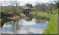
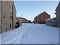
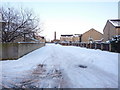
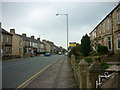
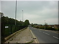
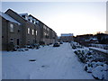
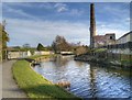
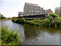
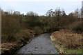
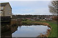
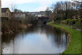
Living in BB12 8AG means inhabiting a tightly packed residential cluster within the Borough of Burnley, Lancashire. The area spans 6,597 square metres and is home to 1,411 people, making it one of the most densely populated places in England, with 213,887 people per square kilometre. Situated north of Burnley town centre, it lies near the Leeds and Liverpool Canal, a historic waterway that once spurred industrial growth through coal and textile industries. The M65 motorway divides it from surrounding districts, but its proximity to Burnley’s core offers easy access to urban amenities. BB12 8AG is part of Gannow Ward, a community with a mix of converted Victorian mills and modern housing. Its character is shaped by its industrial past and recent residential development, with Gannow Business Park standing as a testament to the area’s evolving economy. Residents benefit from nearby rail links and a compact layout, though the high density means space is at a premium.
- Area Type
- Postcode
- Area Size
- 6597 m²
- Population
- 1411
- Population Density
- 6417 people/km²
The property market in BB12 8AG is characterised by a high rate of home ownership—64% of residents own their homes. This suggests a stable, long-term population rather than a transient rental market. The accommodation type is predominantly houses, which, in such a small area, likely means a limited number of properties with potentially higher value. Given the high population density and compact size of the postcode, the housing stock is unlikely to be expansive. Buyers should consider that the area’s small footprint means competition for available homes, particularly for those seeking owner-occupied properties. The mix of historic and modern housing, including converted mills, adds to the area’s distinct character. However, the lack of commercial or industrial properties nearby means the market is focused on residential buyers seeking a compact, established community.
House Prices in BB12 8AG
Showing 24 properties
| Address | Type | Beds | Baths | Last Sale Price | Last Sale Date | |
|---|---|---|---|---|---|---|
| 14 Arkwright Street, Burnley, BB12 8AG | Terraced | 3 | 1 | £165,000 | Sep 2025 | |
| 21 Arkwright Street, Burnley, BB12 8AG | Terraced | 3 | 2 | £165,000 | Oct 2024 | |
| 3 Arkwright Street, Burnley, BB12 8AG | Terraced | 3 | 1 | £185,000 | Apr 2024 | |
| 4 Arkwright Street, Burnley, BB12 8AG | house | - | - | £85,000 | Sep 2021 | |
| 20 Arkwright Street, Burnley, BB12 8AG | house | 3 | - | £205,000 | Sep 2021 | |
| 18 Arkwright Street, Burnley, BB12 8AG | house | - | - | £170,000 | Jul 2021 | |
| 19 Arkwright Street, Burnley, BB12 8AG | Terraced | 3 | 2 | £94,000 | Feb 2021 | |
| 12 Arkwright Street, Burnley, BB12 8AG | Terraced | 4 | - | £83,000 | Dec 2016 | |
| 24 Arkwright Street, Burnley, BB12 8AG | Terraced | 4 | 1 | £85,000 | Nov 2016 | |
| 25 Arkwright Street, Burnley, BB12 8AG | Terraced | 3 | - | £133,000 | Mar 2016 |
Energy Efficiency in BB12 8AG
The lifestyle in BB12 8AG is shaped by its compact layout and proximity to essential amenities. Within practical reach are five retail outlets, including Spar and Farmfoods Rosehill, offering everyday shopping convenience. The area’s rail links to Burnley Barracks, Rose Grove, and Burnley Central stations provide easy access to urban centres, while the nearby Gannow Community Centre serves as a local hub for social activities. Though the data does not list parks or leisure facilities explicitly, the historical presence of the Leeds and Liverpool Canal suggests potential for recreational walks or water-based activities. The mix of retail, transport, and community spaces creates a self-contained environment, though residents may need to travel further for larger shopping or entertainment options. The area’s small size means amenities are concentrated, which can be both a convenience and a limitation depending on individual needs.
Amenities
Schools
The nearest school to BB12 8AG is Whittlefield Primary School, which holds an Ofsted rating of ‘good’. This school serves the local community, offering primary education to children in the area. As the only named school in the data, it is the primary option for families with young children. The absence of secondary schools or other educational institutions nearby means parents may need to travel to Burnley town centre or surrounding areas for higher education. However, the ‘good’ rating indicates a reliable standard of teaching and facilities, which is a positive for families prioritising quality education. The presence of a primary school suggests that BB12 8AG is a family-friendly area, though further research would be needed to confirm the full range of educational options available.
| Rank | School | Type | Entry gender | Ages |
|---|
Explore more schools in this area
Go to Schools tabDemographics
The population of BB12 8AG is predominantly adults aged 30–64, with a median age of 47. This suggests a community of middle-aged residents, likely settled in long-term homes. Home ownership is high at 64%, with houses being the primary accommodation type. The predominant ethnic group is White, reflecting the area’s historical roots in the textile and coal industries. The data does not specify diversity beyond this, but the age profile indicates a stable, mature demographic. With no mention of deprivation levels, the focus remains on the practical aspects of living here: a majority of homeowners in established homes, likely with families. The high proportion of adults suggests a community with fewer young dependents, though the presence of a primary school nearby indicates some family households.
Household Size
Accommodation Type
Tenure
Ethnic Group
Religion
Household Composition
Age
Household Deprivation
NS-SEC
Explore more demographic insights in this area
Go to Demographics tabPlanning
Planning Constraints
- Flood RiskPremium
- Ramsar Wetland SitesPremium
- Area of Outstanding Natural BeautyPremium
- Protected Nature ReservePremium
- Protected WoodlandPremium