Area Overview for CF32 7SL
Photos of CF32 7SL
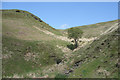

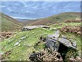

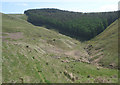
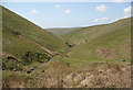
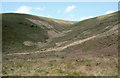
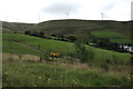

10 photos from this area
Area Information
Key information about the CF32 7SL including its size, population, and administrative classification.
- Area Type
- Postcode
- Area Size
- 60.1 hectares
- Population
- 1755
- Population Density
- 192 people/km²
House Prices in CF32 7SL
16
Properties
£63,833
Average Sold Price
£21,500
Lowest Price
£92,000
Highest Price
Showing 16 properties
| Address | Type | Beds | Baths | Last Sale Price | Last Sale Date | |
|---|---|---|---|---|---|---|
| 16, Aber Houses, Aber Road, Price Town, Nant Y Moel, CF32 7SL | house | 3 | 2 | £92,000 | May 2023 | |
| 22, Aber Houses, Aber Road, Price Town, Nant Y Moel, CF32 7SL | Terraced | 2 | 1 | £65,000 | Feb 2021 | |
| 14, Aber Houses, Aber Road, Price Town, Nant Y Moel, CF32 7SL | Terraced | 2 | - | £75,000 | Feb 2017 | |
| 15, Aber Houses, Aber Road, Price Town, Nant Y Moel, CF32 7SL | house | - | - | £44,000 | Jun 2009 | |
| 17, Aber Houses, Aber Road, Price Town, Nant Y Moel, CF32 7SL | Terraced | - | - | £90,000 | Mar 2008 | |
| 20, Aber Houses, Aber Road, Price Town, Nant Y Moel, CF32 7SL | Terraced | 2 | - | £75,000 | Jul 2007 | |
| 21, Aber Houses, Aber Road, Price Town, Nant Y Moel, CF32 7SL | Terraced | 2 | 1 | £84,995 | Apr 2007 | |
| 18, Aber Houses, Aber Road, Price Town, Nant Y Moel, CF32 7SL | Terraced | - | - | £27,000 | Aug 2002 | |
| 19, Aber Houses, Aber Road, Price Town, Nant Y Moel, CF32 7SL | Terraced | - | - | £21,500 | Sep 2001 | |
| Bridgend County Borough Council, Aberfields Playing Fields And Pavillion, Aber Road, Price Town, Nant Y Moel, CF32 7SL | Leisure | - | - | - | - |
Page 1 of 2
Energy Efficiency in CF32 7SL
Amenities
Schools
| Rank | School | Type | Entry gender | Ages |
|---|
Explore more schools in this area
Go to Schools tabDemographics
Household Size
Family (3-5 people)
most common
Accommodation Type
Houses
most common
Tenure
77
majority
Ethnic Group
White
most common
Religion
N/A
most common
Household Composition
N/A
most common
Age
47
median
Adults (30-64 years)
most common
Household Deprivation
N/A
with no deprivation
NS-SEC
24
in Lower managerial occupations
Explore more demographic insights in this area
Go to Demographics tabPlanning
Planning Constraints
- Flood RiskPremium
- Ramsar Wetland SitesPremium
- Area of Outstanding Natural BeautyPremium
- Protected Nature ReservePremium
- Protected WoodlandPremium
- Crime RiskPremium