Area Overview for CV3 1HG
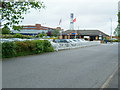
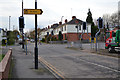
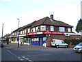
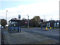
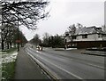
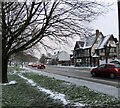
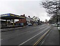
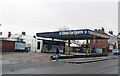
Photos of CV3 1HG


Area Information
CV3 1HG is a compact residential postcode in Coventry’s Lower Stoke Ward, encompassing 1.3 hectares and home to 1,257 residents. Its high population density of 96,814 people per square kilometre reflects a tightly knit community, though the area’s small size means it is more of a cluster than a sprawling suburb. Historically shaped by industrial activity, the area now balances older light industrial estates with newer housing developments, divided by the Coventry-Rugby railway line. Proximity to the city centre and key transport links make it a practical choice for commuters, while its blend of residential and industrial character offers a distinct identity. The area’s roots trace back to Saxon times, with medieval remnants hinting at its past. Today, it is defined by practical living, with residents benefiting from nearby retail, rail, and airport access. For buyers, CV3 1HG represents a mix of affordability, convenience, and a community anchored in Coventry’s evolving urban fabric.
- Area Type
- Postcode
- Area Size
- 1.3 hectares
- Population
- 1257
- Population Density
- 6523 people/km²
The property market in CV3 1HG is dominated by owner-occupied homes, with 73% of residents owning their properties. The area is characterised by houses rather than flats or apartments, reflecting a preference for traditional, single-family dwellings. Given the postcode’s small size and high population density, the housing stock is limited, making it a niche market for buyers seeking compact, practical homes. The area’s proximity to Coventry’s city centre and transport networks may appeal to commuters, though the industrial legacy of the region means properties may be older or require renovation. For buyers, CV3 1HG offers a mix of affordability and convenience, with homes typically situated in a setting that balances residential living with nearby industrial and commercial activity. The lack of luxury or high-end developments suggests a focus on functional, no-frills housing for those prioritising location over architectural grandeur.
House Prices in CV3 1HG
Showing 40 properties
| Address | Type | Beds | Baths | Last Sale Price | Last Sale Date | |
|---|---|---|---|---|---|---|
| 180 Binley Road, Coventry, CV3 1HG | Semi-detached | 3 | 1 | £250,000 | Oct 2023 | |
| 174 Binley Road, Coventry, CV3 1HG | Semi-detached | 3 | 2 | £270,000 | Dec 2022 | |
| 172 Binley Road, Coventry, CV3 1HG | Semi-detached | 3 | 1 | £240,000 | Nov 2020 | |
| 176 Binley Road, Coventry, CV3 1HG | Semi-detached | 4 | 2 | £287,000 | Nov 2019 | |
| 188 Binley Road, Coventry, CV3 1HG | Semi-detached | 5 | 5 | £150,000 | Apr 2017 | |
| 182 Binley Road, Coventry, CV3 1HG | Semi-detached | 3 | 1 | £173,000 | Apr 2017 | |
| 170 Binley Road, Coventry, CV3 1HG | house | - | - | £160,000 | Nov 2014 | |
| 190 Binley Road, Coventry, CV3 1HG | Semi-detached | - | - | £146,000 | Apr 2011 | |
| 184 Binley Road, Coventry, CV3 1HG | Semi-detached | 3 | 2 | - | - | |
| Clean Car Centre Car Wash, 220-222 Binley Road, Coventry, CV3 1HG | Retail | - | - | - | - |
Energy Efficiency in CV3 1HG
Residents of CV3 1HG have access to a range of practical amenities within close proximity. The area includes five retail outlets, such as Lidl Upper, Iceland Binley, and Tesco Ball Hill, ensuring everyday shopping needs are met. While the postcode lacks parks or leisure facilities, its transport links provide access to Coventry’s broader offerings, from cultural attractions to green spaces. The presence of five railway stations and two airports underscores its connectivity, making it easy to reach workplaces, social hubs, or holiday destinations. The industrial character of the area means leisure options are limited to local retail and transport hubs, though the compact layout ensures convenience. For those prioritising practicality over luxury, CV3 1HG offers a straightforward lifestyle with minimal commute times to Coventry’s city centre and beyond.
Amenities
Schools
| Rank | School | Type | Entry gender | Ages |
|---|
Explore more schools in this area
Go to Schools tabDemographics
The population of CV3 1HG is predominantly adults aged 30–64, with a median age of 47. This suggests a mature, stable community, likely with established careers and families. Home ownership is high at 73%, indicating a strong presence of long-term residents. The area is composed mainly of houses, reflecting a preference for single-family living over flats or apartments. The predominant ethnic group is White, though specific data on diversity is not provided. The high population density—96,814 people per square kilometre—means living spaces are closely packed, which may influence the character of the neighbourhood. While no explicit deprivation data is available, the combination of high home ownership and a mature age profile suggests a community with relatively stable economic conditions, though the lack of protected or historic sites may indicate a focus on functional rather than heritage-driven development.
Household Size
Accommodation Type
Tenure
Ethnic Group
Religion
Household Composition
Age
Household Deprivation
NS-SEC
Explore more demographic insights in this area
Go to Demographics tabPlanning
Planning Constraints
- Flood RiskPremium
- Ramsar Wetland SitesPremium
- Area of Outstanding Natural BeautyPremium
- Protected Nature ReservePremium
- Protected WoodlandPremium