Area Overview for B64 7BL
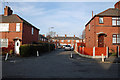
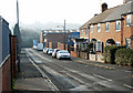
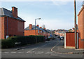
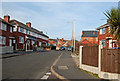
Photos of B64 7BL
Area Information
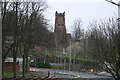
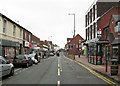
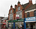
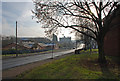
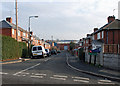
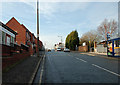
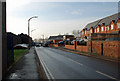
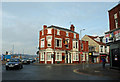
Living in the B64 7BL postcode area means residing within a compact residential cluster defined by a population of 2,094 people spread across just 5,919 square metres. This small locality sits within the Cradley Heath and Old Hill Ward, part of the Sandwell metropolitan borough in the West Midlands. The area encapsulates the urban communities of Cradley Heath and Old Hill, located roughly eight miles west of Birmingham city centre. You are stepping into a region with deep historical roots; originally heathland settled by squatters from the 17th century, it evolved through nail-making and later the famous chain industry, which peaked in 1934. The 1910 chainmakers' strike led by Mary MacArthur remains a notable part of the local story. Today, the landscape retains historical landmarks such as Haden Hill Park, which features Haden Hall and Haden Old Hall dating back to Tudor origins. The area also hosts Mary MacArthur Memorial Gardens and the Church of the Holy Trinity, a Grade II listed building. With a small footprint, daily life revolves close to home, yet the proximity to major transport hubs ensures you remain well-connected to the wider Black Country and beyond.
- Area Type
- Postcode
- Area Size
- 5919 m²
- Population
- 2094
- Population Density
- 2573 people/km²
B64 7BL presents a specific profile for prospective homebuyers due to its tiny geographical footprint and singular housing stock type. The data indicates that Houses are the primary accommodation type, meaning flats and apartments are not the standard offering in this particular postcode. With a population housed in only 5,919 square metres, you cannot expect a sprawling suburban estate; instead, the properties will be set within a concentrated residential cluster. The area is characterised by a home ownership rate of 46%. This percentage signifies that nearly half of the residents either own their homes outright or have a shared mortgage, lending a sense of stability to the local market. For those looking to buy, the environment is not typically a high-turnover rental market. The presence of houses as the dominant accommodation type often correlates with family-oriented living and detached or semi-detached properties, although the extreme density suggests potential close proximity between dwellings. The historical context of the area, originally settled by squatters and shaped by the chain-making industry, likely influences the character of these homes, potentially offering period properties alongside more modern iterations. If you seek traditional housing in a compact setting, this postlode fits that description. You are looking at a niche market where the supply of specific postcode options is limited by the sheer size of the land area.
House Prices in B64 7BL
Showing 1 properties
| Address | Type | Beds | Baths | Last Sale Price | Last Sale Date | |
|---|---|---|---|---|---|---|
| The Solid Swivel Company Limited, Portersfield Road, Cradley Heath, B64 7BL | Industrial | - | - | - | - |
Energy Efficiency in B64 7BL
Daily life in B64 7BL offers convenient access to essential retail and transport hubs within practical reach of residents. For your shopping needs, three major supermarket chains are situated nearby: Iceland Cradley, Lidl Cradley, and Tesco Cradley. These supermarkets provide a comprehensive range of groceries, allowing you to manage your household shopping without the need to travel significant distances. When you need to catch a train, you are close to Cradley Heath Railway Station, Old Hill Railway Station, and Lye Railway Station. These five rail stations facilitate easy travel to Birmingham and other key destinations across the Black Country. Your commuting options extend to road networks as well, with five key routes including Dartmouth Street, Lodge Road, and West Bromwich Central. These roads connect the residential cluster to the wider metropolitan network. Leisure and green space are available through Haden Hill Park, which features Haden Hall and Haden Old Hall. This park offers a dedicated space for walking and outdoor relaxation. The area also benefits from Mary MacArthur Memorial Gardens, providing additional green space and historical context. With a population of 2,094 living in such a small 5,919 square metre area, community facilities are close at hand. The presence of these amenities ensures that residents do not have to venture far for their daily needs or recreational activities.
Amenities
Schools
For families considering living in B64 7BL, educational provision starts very close to home with limited options within the immediate vicinity. The only educational institution listed for this specific area is Cradley Heath Nursery School, which caters to young children and provides a foundation for early learning. This facility serves as a crucial community resource for parents of toddlers and young ones. While no primary, secondary, or further education colleges are explicitly listed in the data for this narrow postcode, the presence of a dedicated nursery indicates that childcare infrastructure is prioritised. The limited school listing reflects the small population size of 2,094 residents in this 5,919 square metre area. Larger areas typically offer more variety in educational choices, but you should note that B64 7BL relies on the nearby nursery for early years education. Families with older children will need to look beyond this immediate postercode cluster or the specific word boundaries defined in the data for comprehensive schooling. The area research mentions the broader ward contains the urban areas of Cradley Heath and Old Hill, implying that households often commute to schools in the wider Sandwell borough if local options are not sufficient for their children's age group. Cradley Heath Nursery School remains the key named entity for education in this specific residential pocket.
| Rank | School | Type | Entry gender | Ages |
|---|
Explore more schools in this area
Go to Schools tabDemographics
The community profile for B64 7BL is distinctly mature, with a median age of 47 years. The most common age range represents adults between 30 and 64 years old, indicating a neighbourhood populated largely by working families and those approaching retirement. This age distribution suggests a stable environment where long-term residents call the area their home. Home ownership stands at 46%, meaning slightly fewer than half of households own their property outright. The remainder of the population resides in rented accommodation, creating a mixed but predominantly owner-occupied mix typical of established working-class wards. The predominant ethnic group in this area is White, reflecting the historical industrial settlement patterns of the Black Country. There are 2,094 residents living in this small space, which contributes to the area's density of 353,793 people per square kilometre. This high density figure underscores how tightly packed the homes are, as the postcode covers a very small residential cluster. Accommodation types are listed simply as Houses, suggesting a scarcity of flats or modern apartments in this specific cluster compared to larger urban zones. You are entering a community defined by its historical identity and a demographic settled enough to own their homes, with a population structure that prioritises family life over transient living arrangements.
Household Size
Accommodation Type
Tenure
Ethnic Group
Religion
Household Composition
Age
Household Deprivation
NS-SEC
Explore more demographic insights in this area
Go to Demographics tabPlanning
Planning Constraints
- Flood RiskPremium
- Ramsar Wetland SitesPremium
- Area of Outstanding Natural BeautyPremium
- Protected Nature ReservePremium
- Protected WoodlandPremium