Area Overview for B63 2QE
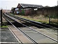
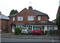
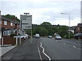
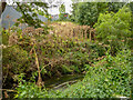
Photos of B63 2QE
Area Information
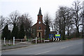
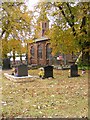
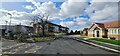
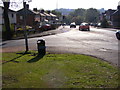
Living in B63 2QE places you within a specific residential cluster in the Dudley metropolitan borough, West Midlands. This postcode covers an area of just 4,461 square metres, housing a population of 1,531 people. The location sits within the Cradley North & Wollescote district, bounded by Halesowen to the east and situated approximately three miles east of Stourbridge town centre. Historically, this region was part of the ancient parish of Halesowen before administrative changes in 1974 merged the local civil parishes into the current borough structure. The immediate surroundings feature familiar landmarks including Wollescote Hall, originally built in 1508, which now serves community groups such as Lye and Wollescote Sons of Rest. Nearby points of interest include St. Peter's Anglican Church, constructed by Dissenters and incorporated into the Church of England in 1799, and the area along Colley Lane that incorporates Cradley's old High Street. Residents benefit from proximity to the Black Country region, an area known for its industrial heritage and later suburban development. Whether you are exploring homes in this postcode or considering the broader landscape of Cradley and Wollescote, the setting offers a distinct mix of suburban residential zones and preserved historic sites. The area has evolved from rural hamlets and former township structures into the dense housing configurations seen today, providing a grounded sense of place for those seeking a home here.
- Area Type
- Postcode
- Area Size
- 4461 m²
- Population
- 1531
- Population Density
- 4055 people/km²
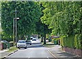
Homes in B63 2QE are predominantly sold as freehold properties within a community where ownership is the norm. Seventy-nine per cent of the local population owns their homes, a figure that defines the nature of the property market in this postcode. The primary accommodation type consists of houses, meaning you will rarely encounter flats or purpose-built rental developments within this specific 4,461 square metre cluster. The historical context of the area reinforces this trend; Wollescote developed into dense post-WWII private and council housing, while Cradley features low-rise homes alongside redeveloped parkland and former estates like Tanhouse. This market structure means that buyers looking for flats in this immediate vicinity face few options. Instead, the focus is on established residential properties that have hosted residents for decades. The high level of ownership suggests that buying into this area represents a substantial commitment, as properties tend to remain with their owners rather than changing hands frequently in the rental sector. If you are considering purchasing, expect the stock to align with the region's historical character, featuring homes that blend into the suburban residential fabric of Cradley and Wollescote. The absence of a significant rental sector in this specific postcode cluster distinguishes it from other parts of the Dudley borough where private renters might be more common. Your search for homes here should prioritise detached, semi-detached, or terrace houses rather than converted apartments or modern-build flats.
House Prices in B63 2QE
No properties found in this postcode.
Energy Efficiency in B63 2QE
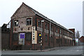
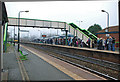
Daily life in B63 2QE is shaped by convenient access to essential amenities located just outside the immediate residential cluster. You have five retail outlets within easy reach, ensuring you can purchase groceries and household essentials without long travel times. Lidl Cradley, Aldi Dudley, and Iceland Cradley are among the specific venues available for shopping, providing ample choice for household needs. For recreational outings, the area offers access to five notable locations, including Dartmouth Street, Lodge Road, and Dudley Street Guns Village. These spots serve as local meeting points and contribute to the suburban character of the neighbourhood. Cultural and leisure activities are anchored by local heritage sites and community spaces. Wollescote Hall, a historic site dating back to 1508, is actively used by groups such as Lye and Wollescote Sons of Rest and Friends of Wollescote Park. St. Peter's Anglican Church offers a further point of interest along Colley Lane, reflecting the area's ecclesiastical history. The presence of Hakon House and other community landmarks suggests an active social fabric where residents engage with local history. While the area is primarily residential, the proximity to these facilities ensures that culture and commerce are accessible without needing to travel into larger town centres like Stourbridge. Living in this postcode provides a balance between quiet home life and access to the practical amenities required for a full daily routine.
Amenities
Schools
| Rank | School | Type | Entry gender | Ages |
|---|
Explore more schools in this area
Go to Schools tabDemographics
The community profile for B63 2QE is defined by a mature population and stable household structures. The median age stands at 47, with adults aged between 30 and 64 years representing the most common age range. Seventy-nine per cent of residents own their homes, indicating a strongly owner-occupied neighbourhood where long-term stability is common. Houses form the primary accommodation type, reflecting the historical development of the area from rural hamlets into established residential zones. The demographic makeup is predominantly White, mirroring the historical settlement patterns of the region. These figures suggest a quiet, family-oriented environment where the majority of inhabitants have deep roots in the local area. The high rate of homeownership means that rental listings are scarce within this specific cluster, and you are more likely to find families or empty nesters settling in for the long term. The age profile indicates that the streets are populated largely by working professionals and retired individuals rather than young people entering property ownership for the first time. This demographic stability often translates to lower turnover rates and a neighbourly atmosphere. When evaluating living in B63 2QE, factor in that the community is not rapidly shifting; it is a settled area where the residents are typically adults who have established themselves within the Dudley borough's boundaries. The lack of significant youth demographics or elderly populations suggests a middle-aged core that values proximity to local services and open spaces.
Household Size
Accommodation Type
Tenure
Ethnic Group
Religion
Household Composition
Age
Household Deprivation
NS-SEC
Explore more demographic insights in this area
Go to Demographics tabPlanning
Planning Constraints
- Flood RiskPremium
- Ramsar Wetland SitesPremium
- Area of Outstanding Natural BeautyPremium
- Protected Nature ReservePremium
- Protected WoodlandPremium