Area Overview for BS23 2EP
Photos of BS23 2EP


Area Information
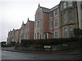
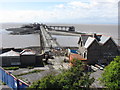
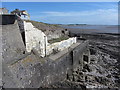
BS23 2EP is a compact residential postcode in England, covering just 1.7 hectares with a population of 1,758 people. Its high population density of 1,564 people per square kilometre reflects a tightly knit community. Situated in the historic town of Weston-super-Mare, this area benefits from its coastal location, though the immediate postcode cluster is a small, inland residential zone. The area’s character is shaped by its proximity to the seaside resort town, which offers a blend of Victorian architecture, historic landmarks, and modern amenities. Residents here are likely to experience a mix of local culture and practical living, with easy access to nearby transport links and retail. The area’s small size means it is likely to feel close-knit, though its density may impact space availability. With a median age of 47 and a majority of adults aged 30–64, the community is mature, potentially attracting professionals or retirees seeking a settled environment.
- Area Type
- Postcode
- Area Size
- 1.7 hectares
- Population
- 1758
- Population Density
- 1564 people/km²
BS23 2EP is a small area with a housing stock dominated by flats, reflecting its high population density and compact footprint. Only 48% of residents are homeowners, indicating that the majority of properties are likely rented. This suggests a rental market that may cater to professionals or families requiring short-term or flexible housing. The prevalence of flats, combined with the area’s limited size, means property options are constrained, potentially leading to higher competition for available units. For buyers, the small postcode area may limit choices, though nearby parts of Weston-super-Mare could offer more variety. The high density also means that properties are likely to be smaller, with shared walls and communal spaces. Prospective buyers should consider the area’s practical limitations and focus on proximity to transport and amenities when evaluating properties.
House Prices in BS23 2EP
Showing 60 properties
| Address | Type | Beds | Baths | Last Sale Price | Last Sale Date | |
|---|---|---|---|---|---|---|
| 11 Upper Kewstoke Road, Weston Super Mare, BS23 2EP | Flat | 2 | 1 | £242,500 | Oct 2025 | |
| 11A Upper Kewstoke Road, Weston Super Mare, BS23 2EP | Flat | 2 | 1 | £215,000 | Jul 2023 | |
| 3 Upper Kewstoke Road, Weston Super Mare, BS23 2EP | Terraced | 3 | 1 | £550,000 | Mar 2023 | |
| 17 Upper Kewstoke Road, Weston Super Mare, BS23 2EP | Terraced | 2 | 1 | £225,000 | May 2022 | |
| Flat 2, 7 Upper Kewstoke Road, Weston Super Mare, BS23 2EP | Flat | 2 | 1 | - | - | |
| 17A Upper Kewstoke Road, Weston Super Mare, BS23 2EP | Flat | 2 | 1 | - | - | |
| Flat 3, Belgravia Mansions, 13 Upper Kewstoke Road, Weston Super Mare, BS23 2EP | Flat | 3 | 1 | - | - | |
| Flat 6A, 5 Upper Kewstoke Road, Weston Super Mare, BS23 2EP | Flat | 2 | 1 | - | - | |
| Wellington House, 1 Upper Kewstoke Road, Weston Super Mare, BS23 2EP | Flat | 1 | 1 | - | - | |
| Flat 1, Wellington House, 1 Upper Kewstoke Road, Weston Super Mare, BS23 2EP | Flat | 2 | 1 | - | - |
Energy Efficiency in BS23 2EP
Living in BS23 2EP offers access to a range of local amenities within walking or short driving distance. Retail options include Spar, Tesco Weston, and Morrisons Daily Weston Super, providing everyday shopping convenience. The area’s three railway stations—Weston, Weston Milton, and Worle—allow easy access to nearby towns and cities, while the nearby ferry service at Weston connects to the Bristol Channel. Though the postcode itself is small, its proximity to Weston-super-Mare’s historic seafront, Victorian architecture, and cultural landmarks adds to its appeal. The compact nature of the area means residents can enjoy a mix of practical living and coastal proximity, though local green spaces or parks are not explicitly detailed in the data. The presence of multiple retail outlets and transport links suggests a lifestyle that balances convenience with the character of a historic seaside town.
Amenities
Schools
| Rank | School | Type | Entry gender | Ages |
|---|
Explore more schools in this area
Go to Schools tabDemographics
The population of BS23 2EP is predominantly adults aged 30–64, with a median age of 47. This suggests a community of established professionals and families, though the 48% home ownership rate indicates that nearly half of residents are renters. Flats are the primary accommodation type, reflecting a compact housing stock suited to the area’s limited space. The predominant ethnic group is White, with no specific data on other demographics. The high population density of 1,564 people per square kilometre means the area is densely populated relative to its size, which may influence local services and social dynamics. While no deprivation data is provided, the presence of 48% owner-occupied homes and a mature age profile suggests a stable, low-turnover community. The lack of detailed diversity metrics means the area’s cultural composition remains less defined in the data.
Household Size
Accommodation Type
Tenure
Ethnic Group
Religion
Household Composition
Age
Household Deprivation
NS-SEC
Explore more demographic insights in this area
Go to Demographics tabPlanning
Planning Constraints
- Flood RiskPremium
- Ramsar Wetland SitesPremium
- Area of Outstanding Natural BeautyPremium
- Protected Nature ReservePremium
- Protected WoodlandPremium