Area Overview for RG2 8RF
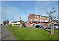
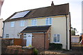
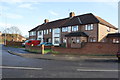
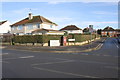
Photos of RG2 8RF
Area Information
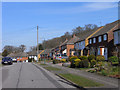
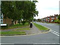
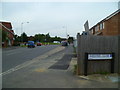
RG2 8RF is a compact residential postcode in England, covering just 6,615 square metres and home to 1,434 residents. Its high population density of 216,782 people per square kilometre reflects its small, tightly knit character. This area is defined by its proximity to local amenities and transport links, making it practical for daily life. The community here is predominantly middle-aged, with a median age of 47, and a strong presence of adults aged 30–64. Most residents own their homes, with 63% of properties in private ownership. The area’s residential cluster feel is complemented by nearby shops, rail stations, and digital connectivity, creating a balance between urban convenience and a sense of local cohesion. Living in RG2 8RF means navigating a space where every square metre is utilised, and daily routines are shaped by the immediacy of nearby services. It’s a place where practicality meets community, with a focus on accessibility over sprawling landscapes.
- Area Type
- Postcode
- Area Size
- 6615 m²
- Population
- 1434
- Population Density
- 2212 people/km²
The property market in RG2 8RF is characterised by a high rate of home ownership—63% of properties are privately owned—suggesting a stable, long-term resident base. The accommodation type is predominantly houses, which is unusual for a small postcode area but may indicate a focus on family-oriented living. This mix of owner-occupied homes and the compact size of the area means the housing stock is limited, with little scope for new developments. Buyers should consider the area’s small footprint and the predominance of houses when evaluating options. The proximity to rail stations and retail amenities may enhance the appeal of properties, but the limited size of RG2 8RF means buyers must prioritise locations within the immediate vicinity.
House Prices in RG2 8RF
Showing 17 properties
| Address | Type | Beds | Baths | Last Sale Price | Last Sale Date | |
|---|---|---|---|---|---|---|
| 40 Blandford Road, Reading, RG2 8RF | Terraced | 3 | 1 | £355,000 | Nov 2017 | |
| 36 Blandford Road, Reading, RG2 8RF | Terraced | 3 | 2 | £236,000 | Nov 2014 | |
| 14 Blandford Road, Reading, RG2 8RF | Semi-detached | 4 | 2 | £180,000 | Aug 2012 | |
| 28 Blandford Road, Reading, RG2 8RF | Semi-detached | - | - | £169,950 | Apr 2006 | |
| 22 Blandford Road, Reading, RG2 8RF | Semi-detached | - | - | £168,000 | Jun 2004 | |
| 18 Blandford Road, Reading, RG2 8RF | house | - | - | £147,000 | Jun 2003 | |
| 20 Blandford Road, Reading, RG2 8RF | Semi-detached | - | - | £143,500 | Dec 2002 | |
| 26 Blandford Road, Reading, RG2 8RF | Semi-detached | - | - | £72,000 | Jan 2002 | |
| 38 Blandford Road, Reading, RG2 8RF | Terraced | - | - | - | - | |
| 30 Blandford Road, Reading, RG2 8RF | Semi-detached | - | - | - | - |
Energy Efficiency in RG2 8RF
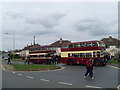
Living in RG2 8RF offers access to essential amenities within practical reach. The area is served by five retail outlets, including Lidl Whitley, Co-op Whitley, and Aldi Unit 6 Gateway Retail Park, providing everyday shopping convenience. Rail connectivity is robust, with five stations nearby, including Reading Railway Station, which links to major transport hubs. While the area lacks expansive parks or leisure facilities, the proximity to rail and retail ensures a practical, service-oriented lifestyle. The compact nature of the area means residents can access shops, transport, and daily necessities without long commutes. The presence of multiple retail options and rail links underscores a focus on functionality, making RG2 8RF ideal for those prioritising convenience over large-scale amenities.
Amenities
Schools
| Rank | School | Type | Entry gender | Ages |
|---|
Explore more schools in this area
Go to Schools tabDemographics
The population of RG2 8RF skews towards middle-aged adults, with a median age of 47 and the majority of residents falling within the 30–64 age range. This suggests a community rooted in established households, likely with children or retired individuals. Home ownership is high at 63%, indicating a stable, long-term resident base. The accommodation type is predominantly houses, which aligns with the area’s residential cluster model. The predominant ethnic group is White, though no specific diversity metrics are provided. The population density of 216,782 people per square kilometre is exceptionally high, which may influence the character of daily life, fostering a tightly knit but potentially crowded environment. This density, combined with the age profile, suggests a community prioritising stability and proximity to services over expansion.
Household Size
Accommodation Type
Tenure
Ethnic Group
Religion
Household Composition
Age
Household Deprivation
NS-SEC
Explore more demographic insights in this area
Go to Demographics tabPlanning
Planning Constraints
- Flood RiskPremium
- Ramsar Wetland SitesPremium
- Area of Outstanding Natural BeautyPremium
- Protected Nature ReservePremium
- Protected WoodlandPremium