Area Overview for M5 3LT
Photos of M5 3LT


Area Information
Living in M5 3LT means inhabiting a compact residential cluster in England, where 2138 people reside across just 1.1 hectares. This high population density creates a tightly knit community, though the area’s small size means every resident is within close proximity to local amenities. The postcode is characterised by a young demographic, with a median age of 22 and most residents aged between 15 and 29. This suggests a dynamic, possibly student or early-career population. The area is not defined by sprawling estates but by a mix of housing types, though the exact layout remains unspecified. Its proximity to transport hubs and retail centres offers convenience, while the surrounding infrastructure, including metro and rail links, supports both daily commutes and broader travel needs. However, the high crime risk score of 0/100 raises practical concerns for residents. For those prioritising density, accessibility, and proximity to services, M5 3LT offers a compact, functional environment, albeit with challenges that demand careful consideration.
- Area Type
- Postcode
- Area Size
- 1.1 hectares
- Population
- 2138
- Population Density
- 8329 people/km²
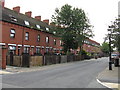
The property market in M5 3LT is defined by low home ownership, with only 16% of residents owning their homes. This suggests a rental-dominated market, where private landlords or housing providers likely hold the majority of properties. The accommodation type is specified as houses, which is atypical for a high-density postcode area, though the exact number of terraced, semi-detached, or detached homes is not provided. This mix may appeal to those seeking more space than typical city apartments, but the small area size means housing stock is limited. For buyers, the low ownership rate could indicate a competitive rental market, with limited opportunities for purchase. The focus on houses may also mean that flats or apartments are rare, which could be a consideration for those prioritising different property types. The area’s compact nature means that property values and availability are likely influenced more by proximity to transport and amenities than by broader regional trends.
House Prices in M5 3LT
Showing 14 properties
| Address | Type | Beds | Baths | Last Sale Price | Last Sale Date | |
|---|---|---|---|---|---|---|
| 24 Robert Hall Street, Salford, M5 3LT | Semi-detached | 3 | 2 | £128,471 | Jul 2015 | |
| 6 Robert Hall Street, Salford, M5 3LT | Semi-detached | 3 | 1 | £128,471 | Jun 2015 | |
| 16 Robert Hall Street, Salford, M5 3LT | Semi-detached | 3 | 2 | £128,471 | Jun 2015 | |
| 14 Robert Hall Street, Salford, M5 3LT | house | 3 | 2 | £128,471 | Jun 2015 | |
| 8 Robert Hall Street, Salford, M5 3LT | Semi-detached | 3 | 2 | £128,471 | Jun 2015 | |
| 4 Robert Hall Street, Salford, M5 3LT | house | 3 | 2 | £128,471 | Jun 2015 | |
| 10 Robert Hall Street, Salford, M5 3LT | house | 3 | 2 | £128,471 | Jun 2015 | |
| 22 Robert Hall Street, Salford, M5 3LT | house | 3 | 2 | £128,471 | Jun 2015 | |
| 12 Robert Hall Street, Salford, M5 3LT | Semi-detached | 3 | 2 | £128,471 | Jun 2015 | |
| 18 Robert Hall Street, Salford, M5 3LT | Semi-detached | 3 | 2 | £128,471 | Jun 2015 |
Energy Efficiency in M5 3LT
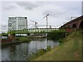
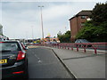
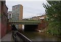
The lifestyle in M5 3LT is shaped by its proximity to a range of amenities, including five retail outlets such as Co-op Salford, Waitrose Little, and Sainsburys Salford. These shops provide everyday essentials, while the metro and rail stations at Cornbrook, Salford Quays, and Anchorage offer access to broader city services. The presence of Salford Central and Deansgate railway stations enhances connectivity to Manchester’s business and cultural centres. For leisure, the nearby City Airport Manchester may offer travel opportunities, though recreational spaces like parks or green areas are not detailed in the data. The single bus stop at Chorlton Street Coach Station provides local transport options, though its limited coverage may restrict access to more distant amenities. Overall, the area’s compact nature ensures that residents can access shops, transport, and travel hubs within short distances, creating a convenient but potentially limited lifestyle compared to larger urban areas.
Amenities
Schools
Residents of M5 3LT have access to two educational institutions within practical reach: Ordsall Community Nursery Centre, which provides early years education, and St Clement’s Egerton CofE Primary School, catering to younger children. The absence of secondary schools in the data means families may need to travel further for secondary education, though the primary options available suggest a focus on early childhood development. The mix of nursery and primary schooling is typical for areas with a high proportion of young residents, though the lack of secondary schools could be a limitation for families planning long-term in the area. Both schools are named in the data, but no Ofsted ratings or performance metrics are provided, leaving their quality unassessed. For parents, the immediate availability of nursery and primary education is a practical advantage, though the absence of secondary options may require careful planning.
| Rank | School | Type | Entry gender | Ages |
|---|
Explore more schools in this area
Go to Schools tabDemographics
The community in M5 3LT is overwhelmingly young, with a median age of 22 and the majority of residents falling within the 15-29 age range. This demographic skew suggests a population of students, early-career professionals, or those in transient housing. Home ownership is low at 16%, indicating that most residents are likely renting, possibly through private landlords or housing associations. The accommodation type is predominantly houses, which is unusual for a high-density area, though the exact distribution of property types is not detailed. The predominant ethnic group is White, with no data provided on other ethnicities. The high proportion of young adults may influence local culture, with social hubs and services tailored to this age group. However, the lack of diversity data means the full composition of the community remains unclear. The combination of youth, rental prevalence, and house-based living shapes a distinct lifestyle, though the area’s small size may limit opportunities for those seeking more varied housing options.
Household Size
Accommodation Type
Tenure
Ethnic Group
Religion
Household Composition
Age
Household Deprivation
NS-SEC
Explore more demographic insights in this area
Go to Demographics tabPlanning
Planning Constraints
- Flood RiskPremium
- Ramsar Wetland SitesPremium
- Area of Outstanding Natural BeautyPremium
- Protected Nature ReservePremium
- Protected WoodlandPremium