Area Overview for L20 8JB
Photos of L20 8JB
Area Information
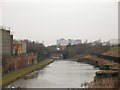
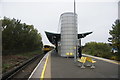
L20 8JB is a defined postcode area in England built around a compact cluster of residential properties. This specific cluster covers 10.2 hectares and holds a population of 2,176 residents. The area is small enough to feel intimate, yet it connects to the wider transport network through nearby rail stations at Bank Hall, Sandhills, and Kirkdale. Those living in L20 8JB often have practical access to coastal ferry terminals linking to Belfast, the Isle of Man, and Dublin via facilities in Bootle, Liverpool, and Seacombe. Daily life here combines proximity to major transport links with the quiet scale of a small residential zone. Homes in this postcode are situated among roughly 21% of residents who own their properties, while the majority remain rented. The land use is almost entirely residential, containing houses rather than flats or mixed developments. You will find the community is centred on practical living arrangements rather than large-scale commercial hubs. This settlement exists within the journey distance of five railway stations and five retail outlets, ensuring you do not need to travel far for essential services. The area represents a utilitarian choice for those prioritising commute access and ferry connectivity over urban density.
- Area Type
- Postcode
- Area Size
- 10.2 hectares
- Population
- 2176
- Population Density
- 1448 people/km²
The housing market in L20 8JB is defined by a sharp split between rental tenants and owner-occupiers. Only 21% of residents own their homes, indicating this is primarily a rental area. The remaining 79% of households rent, making L20 8JB less attractive to first-time buyers who previously inherited a family property or inherited their neighbours. The accommodation type is strictly houses, so you will not find any flats or converted apartments within this cluster. This specificity limits options for buyers seeking smaller, urban-style living. People purchasing homes in this location typically choose established detached or semi-detached dwellings rather than modern conversions. The low percentage of owner-occupied properties suggests that residents may lack the ability to make significant structural changes to their living spaces without landlord consent. For a buyer, this means higher transaction costs regarding mortgages and stricter lending criteria dominates the financial experience compared to owner-led areas. The 10.2 hectares of land contain 2,176 people, creating a neighbourhood where property changes happen less frequently than in high-turnover districts.
House Prices in L20 8JB
Showing 2 properties
| Address | Type | Beds | Baths | Last Sale Price | Last Sale Date | |
|---|---|---|---|---|---|---|
| Yard 4, Redfern Street, Liverpool, L20 8JB | warehouse | - | - | - | - | |
| Warehouse 4B, Yard 4, Redfern Street, Liverpool, L20 8JB | warehouse | - | - | - | - |
Energy Efficiency in L20 8JB
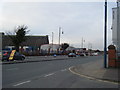
Your daily life in L20 8JB revolves around practical amenities located just beyond the immediate property cluster. Five railway stations serve the area, with notable stops at Bank Hall, Sandhills, and Kirkdale, allowing quick access to wider business districts. Retail needs are met by five local shops, including Spar Brewster, Iceland County, and Farmfoods Kirkdale. These venues provide essential groceries and daily necessities without requiring long drives. If you value maritime options, five ferry terminals operate nearby, connecting you to Belfast, the Isle of Man, and Dublin through hubs in Bootle, Liverpool, and Seacombe. You can reach these destinations with minimal travel time from your home. The 10.2-hectare site contains no major parks or leisure centres, so outdoor activities rely on surrounding green spaces rather than on-site facilities. Living in L20 8JB offers a self-sufficient routine where food, transport, and relaxation are all reachable within a short drive or walk. The concentration of retail and rail infrastructure ensures you never spend excessive time commuting for basic conveniences.
Amenities
Schools
Families looking for schools near L20 8JB have two specific primary options located in close proximity. St Alexander's RC Junior Mixed and Infant School serves as a primary institution for younger children in the catchment. You will also find St Alban's RC Junior Mixed and Infant School nearby, which caters to similar age groups within the area. These Catholic-run schools provide an educational foundation for residents before children transition to secondary education elsewhere. The presence of both mixed and infant stages suggests a manageable local system designed to nurture young learners without requiring immediate relocation. Both institutions operate under the RC designation, meaning religious education and community values play a central role in the curriculum. When planning for children living in this postcode, you should verify if these specific schools accept transfers or fall within the immediate admission zone. The mix of primary education options supports the demographic reality that the area contains many adults with children under 16.
| Rank | School | Type | Entry gender | Ages |
|---|
Explore more schools in this area
Go to Schools tabDemographics
The community in L20 8JB features an older demographic profile compared to many other parts of the UK. The median age stands at 47 years, with the most common age range spanning adults between 30 and 64 years. This suggests the area attracts families who have settled down or professionals working stable roles. Home ownership levels sit at 21%, meaning the vast majority of residents rent rather than own their homes. The accommodation type consists predominantly of houses, indicating a property mix designed for larger families or couples. The predominant ethnic group in L20 8JB is White, reflecting the character of the local housing stock. You are entering an environment where long-term residents likely outnumber recent arrivals. The population density reaches 1,448 people per square kilometre, which shows a moderate concentration of homes within this 10.2-hectare footprint. Living in L20 8JB means sharing a space with approximately two people for every full acre of land. The age structure implies slower community turnover, as the core residents are middle-aged adults who have spent decades in this region.
Household Size
Accommodation Type
Tenure
Ethnic Group
Religion
Household Composition
Age
Household Deprivation
NS-SEC
Explore more demographic insights in this area
Go to Demographics tabPlanning
Planning Constraints
- Flood RiskPremium
- Ramsar Wetland SitesPremium
- Area of Outstanding Natural BeautyPremium
- Protected Nature ReservePremium
- Protected WoodlandPremium