Area Overview for L20 8ER
Photos of L20 8ER
Area Information
Living in L20 8ER means settling into a compact residential cluster defined by its specific postcode boundaries. This small area covers an area of 1451 m² and hosts a population of 2176 people. The density is notable, averaging 1448 people per km². This concentration of residents shapes the local character, creating a neighbourhood where daily life revolves closely around immediate surroundings. You are purchasing a home in a space where every decision impacts a defined community rather than a sprawling district. The environment is residential by nature, with the majority of the land dedicated to housing. There are no large open spaces or industrial zones within this cluster, keeping the focus on domestic living. Prospective buyers should understand that L20 8ER is a specific slice of a larger locality. The area functions as a tightly knit pocket within the wider Bootle region. Daily commutes and errands will likely extend beyond these specific borders, yet the immediate environment is strictly residential. The community is dominated by adults, particularly those in the 30-64 age range. This demographic profile suggests a location suited for families and established professionals rather than retirees seeking quiet retirement homes. You can expect a straightforward, functional neighbourhood where the primary attraction is the housing itself rather than unique local parks or high-street entertainment. The distinct boundaries of L20 8ER ensure that residents live within a clearly defined residential zone.
- Area Type
- Postcode
- Area Size
- 1451 m²
- Population
- 2176
- Population Density
- 1448 people/km²
The property market in L20 8ER is characterised by a low level of ownership and a steady supply of houses for rent. Only 21% of residents own their homes, which classifies this as a rental-heavy market. This statistic is crucial for anyone considering buying a house in L20 8ER, as the local economy supports a high volume of tenants. The accommodation type is exclusively houses, meaning you will not find flats or terraces typical of other urban clusters. This housing stock appeals to those seeking detached or semi-detached structures on a relatively small footprint. The prevalence of rental properties suggests that buyers may find limited choice in outright purchases within this specific 1451 m² cluster. Instead, the primary market activity involves long-term lettings to the 79% of residents renting their homes. For investors, the area offers a volume of potential tenants who are adults in their working lives. The homes in L20 8ER are concentrated tightly, reflecting the higher population density of 1448 people per km². You should view this postcode as a specific node in the wider housing supply where rental demand outweighs owner-occupation. The market operates on the logic of a functional residential zone rather than a luxury investment hub. Familiarising yourself with homes in L20 8ER requires understanding this dynamic between the few owners and the many renters.
House Prices in L20 8ER
No properties found in this postcode.
Energy Efficiency in L20 8ER
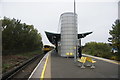
Living in L20 8ER places you moments away from a specific suite of amenities that support daily convenience. Five grocery stores operate within easy reach, most notably the Spar Brewster, Iceland County, and Lidl LIV. These retail locations handle your weekly shopping needs efficiently. Commuting is facilitated by five nearby railway stations, including Bank Hall Railway Station, Sandhills Railway Station, and Kirkdale Railway Station. You can catch trains to Liverpool city centre or beyond without travelling far from the cluster. International travel is accessible via three major ferry terminals. The Liverpool Belfast Ferry Terminal Bootle, Liverpool Isle of Man & Dublin Terminal, and Seacombe Ferry Terminal are all within your practical sprint. This lifestyle is defined by accessibility rather than local leisure. You will spend most of your day within the residential cluster or making short trips to the five named transport and retail hubs. Eating out or finding a dedicated park within L20 8ER requires looking beyond the immediate 1451 m², as the data highlights transport and retail over leisure parks. The 5 railway stations and 5 nearby shops create a functional rhythm for your week. You can rely on Spar Brewster and Lidl LIV for food, and Bank Hall or Sandhills for your commute. The character of the area is utilitarian, prioritising ease of access to mainstream services over unique cultural attractions.
Amenities
Schools
Families living in L20 8ER have access to two specific Catholic primary schools located in the immediate vicinity. St Alexander's RC Junior Mixed and Infant School serves a section of the local catchment for younger children and adolescents. The second option is St Alban's RC Junior Mixed and Infant School, which provides an alternative within the clutch. Both institutions operate as primary schools, meaning secondary education requires travel to a larger facility outside this specific cluster. The schools are named with clear religious affiliations, indicating strong community ties to the local Catholic tradition. You will not find a sixth form college or secondary school listed directly for the L20 8ER postcode, so older children must commute further. The presence of two primary options suggests a deliberate split of student numbers within the local area. Parents can choose between St Alexander's or St Alban's depending on distance or specific curriculum preferences. These schools are the key educational anchors for families living in this residential cluster. If you are looking for schools near L20 8ER with ofsted ratings, the data provided does not include ofsted ratings, so you cannot rely on specific performance metrics from this source alone. You must plan secondary schooling logistics separately.
| Rank | School | Type | Entry gender | Ages |
|---|
Explore more schools in this area
Go to Schools tabDemographics
The community within L20 8ER is heavily weighted towards your economic and life stage. Your neighbours are predominantly adults aged between 30 and 64 years. This is the most common age range in the cluster, reflecting the period of life when individuals typically have stable careers and larger households. The median age of 47 years confirms that this is not a youthful enclave for students or young professionals. There is a significant lack of home ownership, with only 21% of residents owning their homes outright. The remaining 79% occupy rented accommodation, indicating a market driven by tenants rather than long-term owners. Houses form the predominant accommodation type in the area, distinguishing it from zones dominated by high-rise flats. The ethnic composition is predominantly White, though this remains a broad demographic profile for the specific postcode cluster. The high population density of 1448 people per km² means that corridors of homes are closely spaced. This density, combined with the high proportion of renters, suggests a transient aspect to the community turnover. While the specific ethnic makeup is largely White, the area within L20 8ER supports a diverse mix of households defined primarily by age and tenancy status. You are joining a neighbourhood where stability is less common than in owner-occupied districts.
Household Size
Accommodation Type
Tenure
Ethnic Group
Religion
Household Composition
Age
Household Deprivation
NS-SEC
Explore more demographic insights in this area
Go to Demographics tabPlanning
Planning Constraints
- Flood RiskPremium
- Ramsar Wetland SitesPremium
- Area of Outstanding Natural BeautyPremium
- Protected Nature ReservePremium
- Protected WoodlandPremium