Area Overview for BR1 2SB
Photos of BR1 2SB
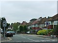
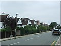
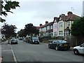
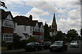
53 photos from this area
Area Information
Key information about the BR1 2SB including its size, population, and administrative classification.
- Area Type
- Postcode
- Area Size
- 9973 m²
- Population
- Not available
- Population Density
- Not available
House Prices in BR1 2SB
25
Properties
£323,464
Average Sold Price
£90,000
Lowest Price
£575,000
Highest Price
Showing 25 properties
| Address | Type | Beds | Baths | Last Sale Price | Last Sale Date | |
|---|---|---|---|---|---|---|
| 44 Nightingale Lane, Bromley, BR1 2SB | Terraced | 2 | - | £450,000 | Nov 2020 | |
| 64 Nightingale Lane, Bromley, BR1 2SB | house | - | - | £520,000 | Nov 2019 | |
| 38 Nightingale Lane, Bromley, BR1 2SB | Terraced | 3 | 2 | £407,500 | Jun 2019 | |
| 32 Nightingale Lane, Bromley, BR1 2SB | house | - | - | £575,000 | Oct 2017 | |
| 42 Nightingale Lane, Bromley, BR1 2SB | house | 2 | - | £425,000 | Apr 2016 | |
| 58 Nightingale Lane, Bromley, BR1 2SB | Semi-detached | 3 | 2 | £470,000 | Jan 2015 | |
| 62 Nightingale Lane, Bromley, BR1 2SB | house | 3 | - | £305,000 | Jul 2012 | |
| 34 Nightingale Lane, Bromley, BR1 2SB | house | - | - | £285,000 | Jan 2012 | |
| 16 Nightingale Lane, Bromley, BR1 2SB | house | - | - | £305,000 | Aug 2009 | |
| 24 Nightingale Lane, Bromley, BR1 2SB | Terraced | - | - | £230,000 | Dec 2003 |
Page 1 of 3
Energy Efficiency in BR1 2SB
Amenities
Schools
| Rank | School | Type | Entry gender | Ages |
|---|
Explore more schools in this area
Go to Schools tabDemographics
Household Size
Family (3-5 people)
most common
Accommodation Type
Houses
most common
Tenure
75
majority
Ethnic Group
White
most common
Religion
N/A
most common
Household Composition
N/A
most common
Age
47
median
Adults (30-64 years)
most common
Household Deprivation
N/A
with no deprivation
NS-SEC
48
in Lower managerial occupations
Explore more demographic insights in this area
Go to Demographics tabPlanning
Planning Constraints
- Flood RiskPremium
- Ramsar Wetland SitesPremium
- Area of Outstanding Natural BeautyPremium
- Protected Nature ReservePremium
- Protected WoodlandPremium