Area Overview for NN3 8XN
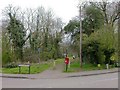
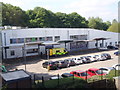
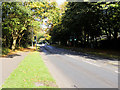
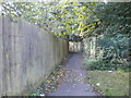
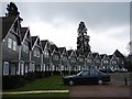
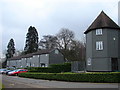
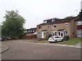
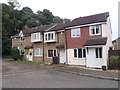
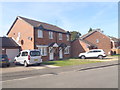
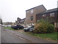
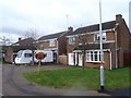
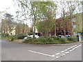
Photos of NN3 8XN
Area Information
NN3 8XN is a compact residential postcode in England, covering just 2 hectares and home to 1,598 people. Its high population density of 78,819 people per square kilometre reflects a tightly knit community, where proximity to amenities and services is a defining feature. The area’s small size means residents share a close-knit environment, with daily life shaped by the immediate availability of shops, transport hubs, and public infrastructure. While the postcode lacks natural landscapes or protected areas, its strategic location near Northampton’s urban core offers easy access to retail, education, and transport networks. The median age of 47 suggests a mature population, with adults aged 30–64 forming the majority. This demographic likely influences the area’s pace of life, balancing routine with the convenience of a well-serviced neighbourhood. For those seeking a compact, functional living space with minimal commute times, NN3 8XN’s blend of practicality and accessibility makes it a compelling choice.
- Area Type
- Postcode
- Area Size
- 2.0 hectares
- Population
- 1598
- Population Density
- 4940 people/km²
The property market in NN3 8XN is defined by a 43% home ownership rate, with houses being the primary accommodation type. This suggests a market skewed towards owner-occupied homes rather than rental properties, though the relatively low home ownership percentage indicates a significant portion of the housing stock is likely rented. The small area size of 2 hectares means the housing stock is limited, which could create competition among buyers. The predominance of houses over flats may appeal to those seeking more space or a traditional family home. However, the compact nature of the postcode means buyers should consider proximity to amenities and transport as key factors. For those prioritising ownership, the area offers a blend of practicality and accessibility, though the limited size may restrict options for larger properties or developments.
House Prices in NN3 8XN
Showing 41 properties
| Address | Type | Beds | Baths | Last Sale Price | Last Sale Date | |
|---|---|---|---|---|---|---|
| 35 Kelmscott Close, Northampton, NN3 8XN | Bungalow | - | - | - | - | |
| 25 Kelmscott Close, Northampton, NN3 8XN | Bungalow | - | - | - | - | |
| 33 Kelmscott Close, Northampton, NN3 8XN | Bungalow | - | - | - | - | |
| 41 Kelmscott Close, Northampton, NN3 8XN | Bungalow | - | - | - | - | |
| 10 Kelmscott Close, Northampton, NN3 8XN | Bungalow | - | - | - | - | |
| 13 Kelmscott Close, Northampton, NN3 8XN | Bungalow | - | - | - | - | |
| 26 Kelmscott Close, Northampton, NN3 8XN | Bungalow | - | - | - | - | |
| 1 Kelmscott Close, Northampton, NN3 8XN | Bungalow | - | - | - | - | |
| 5 Kelmscott Close, Northampton, NN3 8XN | Bungalow | - | - | - | - | |
| 8 Kelmscott Close, Northampton, NN3 8XN | Bungalow | - | - | - | - |
Energy Efficiency in NN3 8XN
Living in NN3 8XN offers convenient access to essential amenities within walking or short driving distance. Retail options include Co-op Northampton, Tesco Northampton, and Lidl Lings, providing a range of shopping and grocery needs. The area’s proximity to Northampton Bus Interchange and University Bus Interchange ensures easy access to public transport, while Northampton Railway Station connects residents to broader regional networks. Though the data does not mention parks or leisure facilities, the presence of multiple retail and transport hubs suggests a lifestyle focused on practicality and connectivity. The compact nature of the postcode means daily errands and commutes are efficient, reducing the need for long travel. This makes NN3 8XN ideal for those prioritising accessibility over expansive natural spaces.
Amenities
Schools
| Rank | School | Type | Entry gender | Ages |
|---|
Explore more schools in this area
Go to Schools tabDemographics
The community in NN3 8XN is predominantly composed of adults aged 30–64, with a median age of 47. This suggests a population focused on established careers and family life, rather than younger professionals or retirees. Home ownership sits at 43%, indicating a mix of owner-occupied properties and rental units. The area is characterised by houses rather than flats, reflecting a preference for single-family dwellings. The predominant ethnic group is White, with no specific data on other demographics. The high population density of 78,819 people per square kilometre means residents live in close proximity, which can foster a sense of community but may also impact privacy. With no mention of deprivation levels, the data does not clarify whether this density correlates with socioeconomic challenges. However, the presence of multiple retail outlets and transport links suggests adequate access to services.
Household Size
Accommodation Type
Tenure
Ethnic Group
Religion
Household Composition
Age
Household Deprivation
NS-SEC
Explore more demographic insights in this area
Go to Demographics tabPlanning
Planning Constraints
- Flood RiskPremium
- Ramsar Wetland SitesPremium
- Area of Outstanding Natural BeautyPremium
- Protected Nature ReservePremium
- Protected WoodlandPremium