Area Overview for NG9 1ES
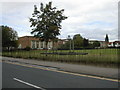
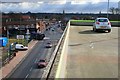
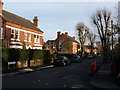
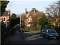
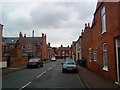
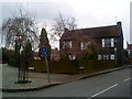
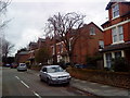
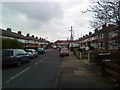
Photos of NG9 1ES

Area Information
NG9 1ES is a compact residential cluster covering exactly 2,854 square metres and home to 1,552 people. You will find this postcode area situated within a densely built‑upon section of England where daily life moves at the pace of established neighbourhoods. The location offers direct access to Chilwell Road, High Road, and a major tram and bus interchange, making it a practical base for commuters. You can reach Co‑op Beeston, Tesco Nottingham, and Lidl Beeston without leaving the immediate vicinity for essential shopping. Beeston Railway Station, Attenborough Railway Station, and Nottingham Railway Station are all within practical reach, alongside Nottingham Airport for travel needs. Living in NG9 1ES means you benefit from a small population yet maintain close proximity to major transport links and retail parks. The area is characterised by its specific residential density and its integration into the wider Beeston and Nottingham corridor. You gain access to reliable digital infrastructure and a safe environment without the congestion typically found in larger city centres. This postcode represents a focused living experience where you have everything you need nearby. The combination of housing, transport, and retail creates a functional environment for residents who value convenience. You do not need to travel far to reach daily necessities or commute hubs. The area serves as a quiet residential pocket with significant connectivity to the surrounding infrastructure network.
- Area Type
- Postcode
- Area Size
- 2854 m²
- Population
- 1552
- Population Density
- 4954 people/km²
Homes in NG9 1ES are characterised by a standing of 64 per cent home ownership, indicating that this postcode is primarily an owner‑occupied area rather than a rental hotspot. The accommodation type is recorded specifically as houses, meaning you will find a stock of detached, semi‑detached, or terraced houses dominating the streets. This type of housing stock typically appeals to families and professionals seeking space and privacy. With a population of 1,552 residents spread across 2,854 square metres, the area is relatively small and densely built, which often supports higher property values. You are looking at a market where neighbours have likely lived in NG9 1ES for many years, creating established values and community ties. The lack of flat or apartment data suggests that multi‑unit developments are not a major feature of this specific cluster. Instead, you will find traditional house styles suited to the local landscape. This makes NG9 1ES an attractive option for buyers who prefer a house over an apartment. The high proportion of owner occupants usually means lower turnover and more stable neighbourhoods. When buying or selling in this area, you engage with a market driven by homeowners who value stability. The specific nature of the housing means you should focus your search on traditional house types rather than modern conversions. This alignment of ownership and dwelling type defines the property landscape for any prospective buyer.
House Prices in NG9 1ES
Showing 23 properties
| Address | Type | Beds | Baths | Last Sale Price | Last Sale Date | |
|---|---|---|---|---|---|---|
| 122A Chilwell Road, Beeston, NG9 1ES | Flat | 1 | 1 | £147,000 | Mar 2024 | |
| 106A Chilwell Road, Beeston, NG9 1ES | Flat | 1 | 1 | £152,500 | Jan 2024 | |
| 104A Chilwell Road, Beeston, NG9 1ES | Flat | - | - | £186,350 | Apr 2022 | |
| 102B CHILWELL ROAD, Beeston, NG9 1ES | Flat | 1 | 1 | £195,000 | Dec 2020 | |
| 112A Chilwell Road, Beeston, NG9 1ES | Maisonette | - | - | £75,000 | Oct 2020 | |
| 110A Chilwell Road, Beeston, NG9 1ES | Flat | 1 | 1 | £95,000 | Apr 2020 | |
| 108A Chilwell Road, Beeston, NG9 1ES | Flat | 1 | 1 | £98,000 | Mar 2020 | |
| 96A Chilwell Road, Beeston, NG9 1ES | Flat | 1 | 1 | £110,000 | Apr 1999 | |
| 114A Chilwell Road, Beeston, NG9 1ES | Flat | 1 | 2 | - | - | |
| 88A Chilwell Road, Beeston, NG9 1ES | Flat | 1 | 1 | - | - |
Energy Efficiency in NG9 1ES
Your daily life in NG9 1ES is supported by a range of amenities located within practical reach of your home. You can shop at Co‑op Beeston for groceries, visit Tesco Nottingham for larger purchases, or choose Lidl Beeston for budget options. These five retail venues ensure you have supermarkets and everyday shopping just moments away. Public transport is just as accessible, with Beeston Railway Station, Attenborough Railway Station, and Nottingham Railway Station offering frequent train connections to the wider region. You can also use the tram and bus interchange located on Chilwell Road and High Road for local travel. Nottingham Airport is nearby if you require flights. There are five notable metro routes and facilities available to you. Living in NG9 1ES means you do not need to drive far for most errands. The concentration of shops and transport hubs within a small 2,854 square metre area maximises convenience. You will find your daily needs met without leaving the immediate neighbourhood. This layout is perfect for those who value a short commute to work and easy access to food and travel. The presence of multiple transport options gives you flexibility in choosing how to get where you need to go. Your lifestyle here is defined by proximity to essential services like Tesco Nottingham and Lidl Beeston. The area offers a balanced mix of retail and transport suitable for regular daily life.
Amenities
Schools
| Rank | School | Type | Entry gender | Ages |
|---|
Explore more schools in this area
Go to Schools tabDemographics
The community in NG9 1ES features a median age of 47 years, with the most common age range falling between 30 and 64 years. This indicates a population dominated by adults who are likely in the middle stages of their careers or approaching retirement. Home ownership stands at 64 per cent, meaning nearly two out of three residents own their properties outright or with a mortgage. This high ownership rate suggests long‑term stability and a community invested in the local area. Most residents live in houses rather than flats or apartments, creating a predominantly detached or semi‑detached housing stock. The predominant ethnic group recorded for this postcode is White, reflecting the broad demographic makeup typical of many established English neighbourhoods. Living in NG9 1ES places you in an area where over half the residents own their homes, fostering a sense of permanence. The age profile suggests a mix of families and professionals rather than young families with small children or large numbers of students. You are part of a neighbourhood where the majority of people are settled and likely to remain for the long term. This demographic stability often translates into quieter streets and established local routines. The combination of a high ownership rate and a mature age profile defines the everyday life here. Schools near NG9 1ES will primarily cater to primary and secondary school‑age children from the surrounding built‑up areas.
Household Size
Accommodation Type
Tenure
Ethnic Group
Religion
Household Composition
Age
Household Deprivation
NS-SEC
Explore more demographic insights in this area
Go to Demographics tabPlanning
Planning Constraints
- Flood RiskPremium
- Ramsar Wetland SitesPremium
- Area of Outstanding Natural BeautyPremium
- Protected Nature ReservePremium
- Protected WoodlandPremium