Area Overview for CF72 8JP
Photos of CF72 8JP
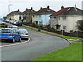
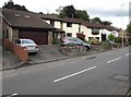
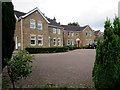
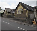
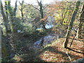
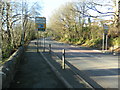
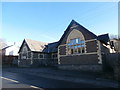

19 photos from this area
Area Information
Key information about the CF72 8JP including its size, population, and administrative classification.
- Area Type
- Postcode
- Area Size
- 4.6 hectares
- Population
- 2031
- Population Density
- 1470 people/km²
House Prices in CF72 8JP
36
Properties
£282,977
Average Sold Price
£34,000
Lowest Price
£597,500
Highest Price
Showing 36 properties
| Address | Type | Beds | Baths | Last Sale Price | Last Sale Date | |
|---|---|---|---|---|---|---|
| 21 Manor Hill, Miskin, Pontyclun, CF72 8JP | Bungalow | 2 | 1 | £550,000 | Sep 2024 | |
| 30 Manor Hill, Miskin, Pontyclun, CF72 8JP | Detached | 2 | 1 | £295,000 | Mar 2024 | |
| 15 Manor Hill, Miskin, Pontyclun, CF72 8JP | Detached | 4 | 1 | £597,500 | Jan 2024 | |
| 32 Manor Hill, Miskin, Pontyclun, CF72 8JP | Detached | 4 | 2 | £550,000 | Jun 2023 | |
| 26 Manor Hill, Miskin, Pontyclun, CF72 8JP | Bungalow | 2 | 1 | £365,000 | Jul 2022 | |
| 22 Manor Hill, Miskin, Pontyclun, CF72 8JP | Detached | 4 | 3 | £500,000 | Dec 2021 | |
| 35 Manor Hill, Miskin, Pontyclun, CF72 8JP | Bungalow | - | - | £375,000 | Sep 2021 | |
| 19 Manor Hill, Miskin, Pontyclun, CF72 8JP | Bungalow | 2 | - | £405,000 | Jun 2021 | |
| 18 Manor Hill, Miskin, Pontyclun, CF72 8JP | Bungalow | 2 | 1 | £375,000 | Apr 2021 | |
| 23 Manor Hill, Miskin, Pontyclun, CF72 8JP | Bungalow | 2 | 1 | £225,000 | Jan 2018 |
Page 1 of 4
Energy Efficiency in CF72 8JP
Amenities
Schools
| Rank | School | Type | Entry gender | Ages |
|---|
Explore more schools in this area
Go to Schools tabDemographics
Household Size
Family (3-5 people)
most common
Accommodation Type
Houses
most common
Tenure
92
majority
Ethnic Group
White
most common
Religion
N/A
most common
Household Composition
N/A
most common
Age
47
median
Adults (30-64 years)
most common
Household Deprivation
N/A
with no deprivation
NS-SEC
59
in Lower managerial occupations
Explore more demographic insights in this area
Go to Demographics tabPlanning
Planning Constraints
- Flood RiskPremium
- Ramsar Wetland SitesPremium
- Area of Outstanding Natural BeautyPremium
- Protected Nature ReservePremium
- Protected WoodlandPremium
- Crime RiskPremium