Area Overview for NP19 0DY
Photos of NP19 0DY

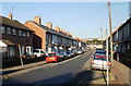
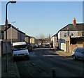


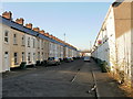
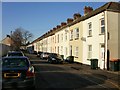
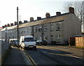

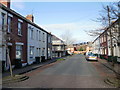
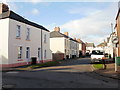
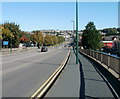
100 photos from this area
Area Information
Key information about the NP19 0DY including its size, population, and administrative classification.
- Area Type
- Postcode
- Area Size
- 5561 m²
- Population
- 2212
- Population Density
- 8778 people/km²
House Prices in NP19 0DY
42
Properties
£86,688
Average Sold Price
£22,000
Lowest Price
£160,000
Highest Price
Showing 42 properties
| Address | Type | Beds | Baths | Last Sale Price | Last Sale Date | |
|---|---|---|---|---|---|---|
| 37 Witham Street, Newport, NP19 0DY | Terraced | 2 | 1 | £145,000 | Aug 2025 | |
| 65 Witham Street, Newport, NP19 0DY | Terraced | 3 | - | £97,000 | Jan 2024 | |
| 75 Witham Street, Newport, NP19 0DY | Terraced | 3 | 1 | £160,000 | Jan 2023 | |
| 15 Witham Street, Newport, NP19 0DY | Retail | 2 | - | £116,000 | Jan 2023 | |
| 1 Witham Street, Newport, NP19 0DY | Terraced | 3 | 1 | £149,000 | Jul 2022 | |
| 51 Witham Street, Newport, NP19 0DY | house | - | - | £115,000 | Sep 2021 | |
| 49 Witham Street, Newport, NP19 0DY | Terraced | 3 | 1 | £110,000 | May 2021 | |
| 23 Witham Street, Newport, NP19 0DY | house | - | - | £118,000 | Dec 2020 | |
| 83 Witham Street, Newport, NP19 0DY | house | - | - | £84,000 | Nov 2020 | |
| 79 Witham Street, Newport, NP19 0DY | Terraced | 3 | 1 | £116,500 | Aug 2019 |
Page 1 of 5
Energy Efficiency in NP19 0DY
Amenities
Schools
| Rank | School | Type | Entry gender | Ages |
|---|
Explore more schools in this area
Go to Schools tabDemographics
Household Size
Family (3-5 people)
most common
Accommodation Type
Houses
most common
Tenure
53
majority
Ethnic Group
White
most common
Religion
N/A
most common
Household Composition
N/A
most common
Age
47
median
Adults (30-64 years)
most common
Household Deprivation
N/A
with no deprivation
NS-SEC
20
in Lower managerial occupations
Explore more demographic insights in this area
Go to Demographics tabPlanning
Planning Constraints
- Flood RiskPremium
- Ramsar Wetland SitesPremium
- Area of Outstanding Natural BeautyPremium
- Protected Nature ReservePremium
- Protected WoodlandPremium
- Crime RiskPremium