Area Overview for CF48 4TJ
Photos of CF48 4TJ


Area Information
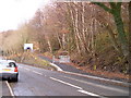
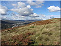
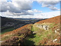
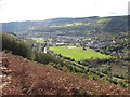
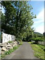
Living in CF48 4TJ means residing within a compact residential cluster in Troedyrhiw, a village located approximately 3 miles south of Merthyr Tydfil town centre. This specific postcode covers an area of 2.3 hectares that accommodates 1,475 residents. The location sits in the Taff Valley within the Merthyr Tydfil County Borough, offering a quiet existence away from the immediate town centre but close enough for practical access. The village itself has a deep history, evolving from an ancient farm homestead and coal mining community into today's modern residential setting. Residents enjoy the peace of a small settlement while remaining reachable by road to local services. The area's identity is rooted in its working-class heritage and its geographical position at the foot of the hill linking several local byways. You will find a community that values its local history, evidenced by maintained historical sites like the Saron Welsh Congregational Chapel graveyard. The village atmosphere remains traditional, shaped by its proximity to the broader Merthyr Tydfil urban area while retaining distinct rural character.
- Area Type
- Postcode
- Area Size
- 2.3 hectares
- Population
- 1475
- Population Density
- 82 people/km²
The housing stock in CF48 4TJ is characterised by a strong presence of houses, with 57 per cent of residents being home owners. This figure places the area in a category where owner-occupiers form the significant majority, distinguishing it from zones dominated by private or social rental sectors. The 2.3-hectare footprint supports 1,475 people, creating a low-density environment where house types likely include detached or semi-detached properties common in former mining villages. You are buying into a market where stability is high, as nearly six in ten households have linked their fortune and lifestyle to property in this specific postcode. The absence of high-rise blocks or dense flats reinforces the village feel, making this location suitable for those preferring traditional home ownership models. The demographic data showing that adults aged 30 to 64 years constitute the largest group further supports the idea that this is a family-friendly market with established tenure. Prospective buyers should note that competition may be moderate rather than fierce, given the specific constraints of such a small geographic cluster. The property landscape reflects a community that has retained its suburban and rural character rather than converting rapidly to student or commuter housing blocks.
House Prices in CF48 4TJ
Showing 4 properties
| Address | Type | Beds | Baths | Last Sale Price | Last Sale Date | |
|---|---|---|---|---|---|---|
| 3, Russell Villas, Aberfan Road, Aberfan, Merthyr Tydfil, CF48 4TJ | Terraced | - | - | - | - | |
| 2, Russell Villas, Aberfan Road, Aberfan, Merthyr Tydfil, CF48 4TJ | house | - | - | - | - | |
| 1, Russell Villas, Aberfan Road, Aberfan, Merthyr Tydfil, CF48 4TJ | Terraced | - | - | - | - | |
| Cartref, Aberfan Road, Aberfan, Merthyr Tydfil, CF48 4TJ | Detached | - | - | - | - |
Energy Efficiency in CF48 4TJ
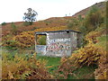
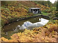
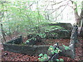
Daily life in CF48 4TJ revolves around a selection of local amenities situated within practical reach of the residential cluster. Residents have access to five nearby retail outlets, including specific venues such as Morrisons Daily, Co-op Pentrebach, and Iceland Merthyr. These shops handle the essentials for grocery shopping and daily needs without requiring a long journey. Trade and daily commerce are also supported by five local rail stations in the vicinity, ensuring connectivity to broader employment hubs. The area benefits from its location near Troedyrhiw Railway Station, which sits close to the historic Saron Welsh Congregational Chapel site. Community life remains active through local projects like the Friends of Saron group, which maintains the overgrown graveyard of the former 1852 chapel. You will find leisure options linked to local clubs, such as the Troedyrhiw Boys' Club founded in 1932, which has served the community for generations. The village character mixes modern convenience with historical significance, offering a backdrop of industrial heritage. Religious history adds depth to the local landscape, with multiple chapels like Bethel and Mount Zion leaving marks on the community's identity. History remains present in the area, balancing the everyday needs of modern shoppers.
Amenities
Schools
| Rank | School | Type | Entry gender | Ages |
|---|
Explore more schools in this area
Go to Schools tabDemographics
The community in CF48 4TJ is predominantly defined by established families and long-term residents rather than transient housing. A median age of 47 years indicates a mature population where adults between 30 and 64 years old form the most common age range. This demographic profile suggests stability within the local houses, which constitute the primary accommodation type. Home ownership levels stand at 57 per cent, meaning more than half of the residents own their dwellings outright. The predominant ethnic group identifies as White, reflecting the area's origins as a traditional Welsh mining village. While specific data on deprivation is not provided in this dataset, the high home ownership rate and settled age profile typically correlate with lower housing pressure compared to hot rental markets. Buyers looking at homes in this cluster will join a neighbourhood where most families have deep ties to the area. The density stands at 82 people per square kilometre, suggesting a layout that is spread out rather than tightly packed. This spaciousness suits families and couples seeking a low-density living environment without complete isolation from towns like Merthyr Tydfil.
Household Size
Accommodation Type
Tenure
Ethnic Group
Religion
Household Composition
Age
Household Deprivation
NS-SEC
Explore more demographic insights in this area
Go to Demographics tabPlanning
Planning Constraints
- Flood RiskPremium
- Ramsar Wetland SitesPremium
- Area of Outstanding Natural BeautyPremium
- Protected Nature ReservePremium
- Protected WoodlandPremium
- Crime RiskPremium