Area Overview for LL41 3AG
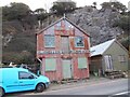
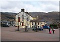
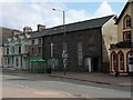
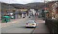
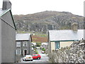
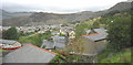
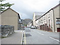
Photos of LL41 3AG

Area Information
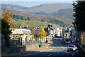
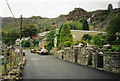
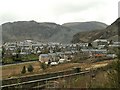
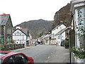
LL41 3AG is a small residential cluster in Wales, covering 983 square metres and home to 1778 residents. The area has a low population density of 68 people per square kilometre, suggesting a quiet, spread-out community feel. With a median age of 47 and a majority of residents aged 30–64, this is a mature neighbourhood where many have established long-term ties. The area is predominantly owner-occupied, with 62% of homes owned by residents, and houses are the primary accommodation type. Daily life here is likely characterised by a balance of local amenities and natural surroundings, though the data does not indicate proximity to major attractions or services beyond nearby shops and transport links. The absence of protected natural areas or planning constraints may offer flexibility for future development, though the low flood risk score of 0.5 ensures peace of mind for homeowners. Living in LL41 3AG appears to prioritise stability, with a focus on residential comfort over high-density urban living.
- Area Type
- Postcode
- Area Size
- 983 m²
- Population
- 1778
- Population Density
- 68 people/km²
The property market in LL41 3AG is characterised by a high rate of home ownership, with 62% of residents owning their homes. This indicates a community where long-term residency is common, and property values may be influenced by the area’s low population density and residential focus. The predominant accommodation type is houses, suggesting a market skewed towards single-family homes rather than apartments or flats. This is likely to appeal to buyers seeking space and privacy, though the small area size of 983 square metres may limit the availability of new developments. For buyers, the market may offer a mix of established properties with potential for future value retention, given the absence of planning constraints such as protected woodlands or areas of outstanding natural beauty. However, the limited size of the area means that the immediate surroundings may need to be considered for a broader range of property options.
House Prices in LL41 3AG
No properties found in this postcode.
Energy Efficiency in LL41 3AG
Residents of LL41 3AG have access to a range of local amenities within practical reach. Three retail outlets, including Co-op Blaenau, Morrisons Blaenau, and Spar, offer everyday shopping needs. The area’s rail network includes five stations, such as Blaenau Ffestiniog and Roman Bridge, while a metro station at Tanygrisiau provides additional transport options. Though the data does not mention parks or leisure facilities, the absence of protected natural areas or planning constraints may allow for local recreational spaces. The combination of retail, transport, and proximity to stations suggests a lifestyle that balances convenience with a quieter, more residential environment. For those who prioritise easy access to shops and transport, LL41 3AG offers a functional setup, though the lack of detailed information on leisure options means further exploration is recommended.
Amenities
Schools
The nearest school to LL41 3AG is Ysgol Gynradd Tanygrisiau, which is categorised as an "other" school type. No further details about its Ofsted rating or curriculum are provided in the data. Given the area’s population of 1778 and the presence of a single named school, it is likely that the educational options are limited to primary or secondary levels, though the exact age range served is unclear. The absence of additional schools in the data suggests that families may need to look beyond the immediate vicinity for a broader range of educational institutions. The school’s type and the lack of further details mean that prospective homebuyers should conduct independent research to assess its quality and suitability for their children’s needs.
| Rank | School | Type | Entry gender | Ages |
|---|
Explore more schools in this area
Go to Schools tabDemographics
The population of LL41 3AG is 1778, with a median age of 47 and the most common age range being adults aged 30–64. This suggests a community of middle-aged individuals, likely with established careers and families. Home ownership is high at 62%, indicating a strong presence of long-term residents. The area is predominantly composed of houses rather than flats or apartments, reflecting a traditional housing stock. The predominant ethnic group is White, though no further breakdown of diversity is provided. With a population density of 68 people per square kilometre, the area is not densely populated, allowing for a more spacious, low-pressure living environment. This density level may contribute to a quieter, less congested lifestyle compared to urban centres. The data does not specify deprivation levels, but the combination of home ownership and stable demographics suggests a relatively stable economic profile for the area.
Household Size
Accommodation Type
Tenure
Ethnic Group
Religion
Household Composition
Age
Household Deprivation
NS-SEC
Explore more demographic insights in this area
Go to Demographics tabPlanning
Planning Constraints
- Flood RiskPremium
- Ramsar Wetland SitesPremium
- Area of Outstanding Natural BeautyPremium
- Protected Nature ReservePremium
- Protected WoodlandPremium
- Crime RiskPremium