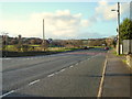
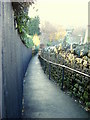
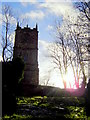
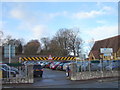
Area Overview for Mold Community
Photos of Mold Community
Area Information
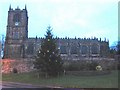
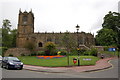
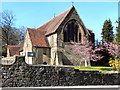
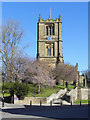
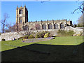
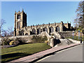
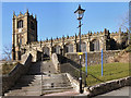
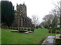
Mold Community sits within Flintshire, North Wales, covering an area of 6.6 square kilometres. It operates as a civil parish with a population of 2,319 residents. This settlement functions as part of the wider Mold market town, which serves as the administrative centre for the county. The town's layout historically revolves around the site of Mold Castle, a Norman motte and bailey structure built between 1072 and 1140. Although the original stone structures no longer survive, the town developed around this military stronghold with a planned High Street designed for market traders. The current community inherits a deep history involving wool production, trading, and later coal industries that influenced the region in previous centuries. Saint Mary's parish church remains a notable landmark, recognised as one of the finest ecclesiastical buildings in Wales. Residents live in a parish with specific boundaries, offering a defined local identity distinct from the larger town administration. The physical space is compact at 6.6 square kilometres, creating a close-knit environment despite the historical depth of the settlement. Daily life here is shaped by the legacy of being a historic county town, where administrative buildings and market traditions coexist with modern residential needs.
- Area Type
- Parish
- Area Size
- 6.6 km²
- Population
- 2319
- Population Density
- 352 people/km²
Demographics
The community hosts 2,319 people across 6.6 square kilometres, resulting in a population density of 352 people per square kilometre. The median age within the area is 70 years, indicating a significant older demographic compared to national averages. This age profile suggests the area may attract retirees or older long-term residents who prefer a slower pace of life. Home ownership is the dominant tenure, with 73%% of residents owning their homes outright or with a mortgage. This high percentage points toward a stable community where most people have settled permanently rather than renting temporarily. Household composition and accommodation type data categorise the total population, reflecting a mix of dwelling sizes suitable for various family needs. The ethnic and religious data cover the total population, showing the diversity within this specific parish. The low population density combined with the high median age creates a demographic profile typical of established rural parishes near historic towns. For potential buyers, this means you are entering a market where ownership is the norm and the demographic skew is towards older age groups.
Household Size
Accommodation Type
Tenure
Ethnic Group
Religion
Household Composition
Age
Household Deprivation
NS-SEC
Explore more demographic insights in this area
Go to Demographics tabPlanning
Planning Constraints
- Flood RiskPremium
- Ramsar Wetland SitesPremium
- Area of Outstanding Natural BeautyPremium
- Protected Nature ReservePremium
- Protected WoodlandPremium
- Crime RiskPremium