Area Overview for CH8 9DS
Photos of CH8 9DS


Area Information
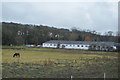
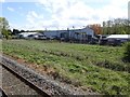
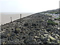
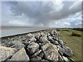
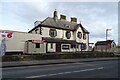
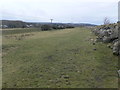
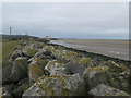
Living in CH8 9DS, a small residential cluster in north Wales, offers a quiet, low-density lifestyle with a population of 1,891 spread across 160 people per square kilometre. Situated in Mostyn, a village on the River Dee estuary, the area blends historical significance with modern practicality. Mostyn’s roots trace back to the Domesday Book, yet today it serves as a commuter hub for nearby Holywell and Flint. The local economy, historically reliant on coal and iron, now supports offshore wind projects and port activities, including exporting aircraft parts. Residents benefit from proximity to rail links and a mix of retail options. While the community is small, its strategic location near the Dee estuary and transport networks makes it appealing for those seeking a balance between rural tranquillity and accessible amenities. The area’s character is defined by its heritage, with St. Margaret’s Church and a privately owned port still influencing its identity. For buyers, CH8 9DS represents a niche market where property values may reflect both historical charm and contemporary infrastructure needs.
- Area Type
- Postcode
- Area Size
- Not available
- Population
- 1891
- Population Density
- 160 people/km²
The property market in CH8 9DS is characterised by a 58% home ownership rate, with houses being the primary accommodation type. This suggests a predominantly owner-occupied area, though the relatively small population and low density mean the market is not large or diverse. The focus on houses rather than flats or apartments indicates a preference for traditional, family-sized homes, which may appeal to buyers seeking space and privacy. Given the area’s small size, property values are likely influenced by proximity to the River Dee, rail links, and historical sites. However, the limited number of properties means competition for homes could be low, though buyers should consider the area’s niche appeal. The market may also reflect the local economy’s reliance on transport and industry, with properties possibly catering to commuters or those working in nearby sectors.
House Prices in CH8 9DS
No properties found in this postcode.
Energy Efficiency in CH8 9DS
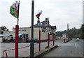
Residents of CH8 9DS have access to five retail outlets within practical reach, including Tesco Holywell, Iceland Holywell, and Lidl Holywell, ensuring everyday shopping needs are met. The area’s rail links to Flint and West Kirby provide access to broader leisure and dining options beyond the immediate vicinity. While the postcode itself has limited local parks or recreational spaces, the proximity to the River Dee and nearby towns suggests opportunities for outdoor activities. The lifestyle in CH8 9DS is defined by convenience for commuters and a quiet, community-focused environment. The retail options and rail connectivity make it practical for those who work elsewhere but seek a residential base with a low population density. The area’s charm lies in its balance between historical heritage and modern amenities, though buyers should consider the need for nearby facilities for more specialised needs.
Amenities
Schools
Residents of CH8 9DS have access to two schools: Ysgol Bryn Pennant C.P. and The Clocktower School. Both are listed as ‘other’ types, though specific details on their age ranges or Ofsted ratings are not provided. The presence of two schools suggests a basic educational infrastructure, though the lack of further information means it is unclear whether they cater to primary, secondary, or mixed-age groups. For families, this mix of schools may offer flexibility, but the absence of performance data limits the ability to assess quality. The schools’ proximity to the area indicates they are likely within walking distance for many residents, supporting a community-oriented approach to education. However, buyers seeking top-rated schools may need to look further afield for more comprehensive options.
| Rank | School | Type | Entry gender | Ages |
|---|
Explore more schools in this area
Go to Schools tabDemographics
CH8 9DS has a median age of 47, with the majority of residents aged 30–64, indicating a mature, stable community. Home ownership stands at 58%, suggesting a mix of long-term residents and owner-occupied properties. The predominant accommodation type is houses, aligning with the area’s low population density. The White ethnic group forms the largest demographic, though no specific data on diversity or deprivation is provided. This age profile implies a population largely focused on established careers and family life, with fewer young families or retirees compared to other areas. The absence of specific data on deprivation means the quality of life cannot be fully contextualised, but the demographic stability suggests a community with consistent needs for local services and infrastructure. The age range also hints at a workforce likely tied to nearby industries, including the port and transport sectors.
Household Size
Accommodation Type
Tenure
Ethnic Group
Religion
Household Composition
Age
Household Deprivation
NS-SEC
Explore more demographic insights in this area
Go to Demographics tabPlanning
Planning Constraints
- Flood RiskPremium
- Ramsar Wetland SitesPremium
- Area of Outstanding Natural BeautyPremium
- Protected Nature ReservePremium
- Protected WoodlandPremium
- Crime RiskPremium