Area Overview for CH8 7QU
Photos of CH8 7QU
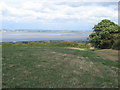
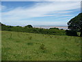
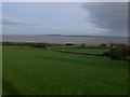
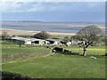
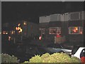
5 photos from this area
Area Information
Key information about the CH8 7QU including its size, population, and administrative classification.
- Area Type
- Postcode
- Area Size
- 29.2 hectares
- Population
- 1549
- Population Density
- 361 people/km²
House Prices in CH8 7QU
19
Properties
£187,086
Average Sold Price
£78,000
Lowest Price
£275,000
Highest Price
Showing 19 properties
| Address | Type | Beds | Baths | Last Sale Price | Last Sale Date | |
|---|---|---|---|---|---|---|
| Parys House, Greenfield Road, Greenfield, CH8 7QU | Land | 6 | 3 | £260,000 | Dec 2019 | |
| The Old Post Office, Greenfield Road, Greenfield, CH8 7QU | Land | 3 | - | £268,000 | Nov 2019 | |
| The Old Police Station, Greenfield Road, Greenfield, CH8 7QU | Detached | 3 | 1 | £125,000 | Apr 2017 | |
| Parkside, Greenfield Road, Greenfield, CH8 7QU | Detached | 3 | 1 | £181,100 | Aug 2014 | |
| Blackmore House, Greenfield Road, Greenfield, CH8 7QU | Detached | - | - | £275,000 | Apr 2013 | |
| Westholme, Greenfield Road, Greenfield, CH8 7QU | house | - | - | £122,500 | Mar 2013 | |
| Greystones, Greenfield Road, Greenfield, CH8 7QU | Detached | - | - | £78,000 | May 2003 | |
| 2, Heritage Court, Greenfield Road, Greenfield, CH8 7QU | Flat | 2 | 1 | - | - | |
| Ty Coch Farm, Greenfield Road, Greenfield, CH8 7QU | Detached | - | - | - | - | |
| Heathfield, Greenfield Road, Greenfield, CH8 7QU | Detached | 2 | - | - | - |
Page 1 of 2
Energy Efficiency in CH8 7QU
Amenities
Schools
| Rank | School | Type | Entry gender | Ages |
|---|
Explore more schools in this area
Go to Schools tabDemographics
Household Size
One person
most common
Accommodation Type
Houses
most common
Tenure
52
majority
Ethnic Group
White
most common
Religion
N/A
most common
Household Composition
N/A
most common
Age
47
median
Adults (30-64 years)
most common
Household Deprivation
N/A
with no deprivation
NS-SEC
15
in Lower managerial occupations
Explore more demographic insights in this area
Go to Demographics tabPlanning
Planning Constraints
- Flood RiskPremium
- Ramsar Wetland SitesPremium
- Area of Outstanding Natural BeautyPremium
- Protected Nature ReservePremium
- Protected WoodlandPremium
- Crime RiskPremium