Area Overview for CH7 1RD
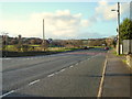
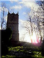
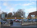
Photos of CH7 1RD

Area Information
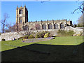
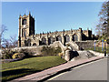
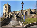
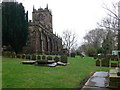
The postcode area CH7 1RD represents a specific residential cluster situated within the historic market town of Mold in Flintshire, North Wales. This small geographic pocket covers 353 square metres and serves a population of 1,437 people. The location offers a distinct advantage regarding flood safety, passing assessment criteria with a low risk score of 2.83, which indicates limited flood coverage in the immediate vicinity. Residents also benefit from a clean environmental record, as the area contains no Ramsar wetland sites, Areas of Outstanding Natural Beauty, protected nature reserves, or protected woodland. The settlement itself sits in the agricultural region to the west of Flintshire, overlooking the Alyn Valley. Its name derives from the Norman-French term *mont-hault*, meaning high hill, originally referring to the site of Mold Castle. While the castle's stone structures no longer exist, the town developed around this historic motte and bailey foundation, creating a layout that still defines the local character today. Living in CH7 1RD means being part of a community with deep historical roots, situated in a region that once served as a critical borderland between Wales and England. The area combines the convenience of a town centre with the specific constraints and benefits found in this small, defined cluster.
- Area Type
- Postcode
- Area Size
- 353 m²
- Population
- 1437
- Population Density
- 1475 people/km²
Homes in CH7 1RD reflect a settled market character driven by a 61% home ownership rate. The data indicates that the predominant accommodation type is houses, a common feature in the historic market town of Mold. This high ownership percentage suggests a stable neighbourhood where residents are long-term rather than transient renters. The area covers a small footprint of 353 square metres and serves a population of 1,437, creating a tight-knit housing environment. Living in this postcode means looking primarily at established properties rather than new developments. The market dynamics are influenced by the town's historical role as an administrative centre for Flintshire. Buyers should expect a mix of properties typical of a town that has faced industrial changes from the 18th century onward. The presence of such a high ownership rate often correlates with stronger community ties and lower tenant turnover. Prospective buyers will find a stock that reflects the settlement's age, with many homes in the area likely being period properties given the Norman foundations of the town layout.
House Prices in CH7 1RD
Showing 3 properties
| Address | Type | Beds | Baths | Last Sale Price | Last Sale Date | |
|---|---|---|---|---|---|---|
| 1, Bailey Villas, Gwernaffield Road, Mold, CH7 1RD | house | - | - | £123,500 | Jun 2022 | |
| Public Conveniences, Maes Y Dre, Mold, CH7 1RD | commercial | - | - | - | - | |
| 2, Bailey Villas, Gwernaffield Road, Mold, CH7 1RD | Terraced | - | - | - | - |
Energy Efficiency in CH7 1RD
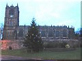
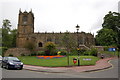
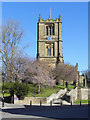
Lifestyle choices for residents of CH7 1RD revolve around the practical amenities found within practical reach of Mold. Retail options are well-developed, with five key venues serving the local population. Notable supermarkets include Lidl Mold, Morrisons Daily Mold 18, and Aldi Mold, ensuring residents can access groceries without travelling far. Transport links are equally accessible, with five railway stations in close proximity. Residents can easily reach Buckley Railway Station, Penyffordd Railway Station, or Hawarden Railway Station for regional travel and commute. Living in this area means enjoying the convenience of established market town facilities. The town itself boasts historical landmarks such as Mold Castle, which anchors the local identity, and St. Mary's parish church, described as one of the finest ecclesiastical buildings in Wales. The High Street, originally laid out to accommodate market traders, remains a central feature of the neighbourhood. The economy of the broader area functions as a market centre for the surrounding agricultural region, providing trade and services. Low population density in the immediate postcode ensures a quieter residential existence while major amenities remain within easy striking distance.
Amenities
Schools
Families looking at CH7 1RD have access to specific educational provisions, with The Lighthouse School identified as the notable nearby institution. This facility is classified as other, indicating it operates outside standard school categories. The availability of educational options is essential for households considering this location. While only one school is listed in the immediate data, the proximity to Mold ensures access to other local institutions not detailed in this specific extract. The presence of any educational establishment within practical reach supports families who require schooling for their children. Living in an area with named schools like The Lighthouse School provides reassurance for parents regarding local amenities. The mix of school types in the wider town of Mold would offer varied educational pathways, but the specific data confirms The Lighthouse School as the direct nearby option for residents of CH7 1RD. Families should research the specific curriculum and admission arrangements for this institution to determine its suitability.
| Rank | School | Type | Entry gender | Ages |
|---|
Explore more schools in this area
Go to Schools tabDemographics
The community within CH7 1RD is defined by a mature population profile, with a median age of 47 years. The most common age range consists of adults between 30 and 64 years, suggesting homes in this area attract families or individuals in their middle years of life. Home ownership stands at 61%, indicating a stable neighbourhood where the majority of residents live in their own property. This high level of ownership contributes to a settled community atmosphere rather than a transient rental market. The predominant ethnic group in the area is White, reflecting the demographic makeup of wider Flintshire and North Wales. The primary accommodation type comprises houses, which aligns with the older median age and the preference for detached or semi-detached living common in older market towns. The small population of 1,437 people ensures that every resident is likely familiar with their neighbours. This demographic structure creates a quiet, stable environment where daily life moves at a pace dictated by local routines rather than the hustle of a commercial district.
Household Size
Accommodation Type
Tenure
Ethnic Group
Religion
Household Composition
Age
Household Deprivation
NS-SEC
Explore more demographic insights in this area
Go to Demographics tabPlanning
Planning Constraints
- Flood RiskPremium
- Ramsar Wetland SitesPremium
- Area of Outstanding Natural BeautyPremium
- Protected Nature ReservePremium
- Protected WoodlandPremium
- Crime RiskPremium