Area Overview for CH7 1FT
Photos of CH7 1FT


Area Information
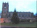
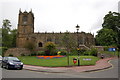
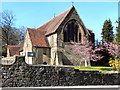
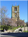
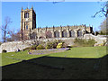
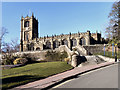
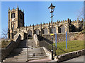
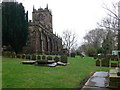
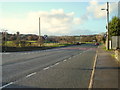
CH7 1FT occupies a small residential cluster within the wider town of Mold, located in Flintshire, North Wales. This specific postcode covers just over eight thousand square metres, containing a compact community of 1,437 residents. The population density is exceptionally high at 179,092 people per square kilometre, which characterises this as a tightly knit living environment rather than a spread-out suburb. You will find yourself in a historic market town that serves as the administrative centre of the county. The area has deep historical roots, originating from the Norman establishment of Mold Castle between 1072 and 1140. The town developed around this fortress with a planned layout featuring a wide High Street designed for market traders. Living in CH7 1FT means residing in a location that has functioned as an agricultural hub since the medieval period. While the immediate surrounding area offers high-density living, the town itself overlooks the Alyn Valley. The location provides a connection to the administrative history of Flintshire, where Quarter Sessions were based from the 1760s. This postcode area represents a specific slice of the historic county town, offering a sense of place rooted in centuries of local trade and governance.
- Area Type
- Postcode
- Area Size
- 8024 m²
- Population
- 1437
- Population Density
- 1475 people/km²
The housing stock in CH7 1FT is defined by its scarcity and specific tenure structure. With only 61% of residents owning their homes, the area maintains a significant proportion of rented properties alongside owner-occupied houses. Houses are the predominant accommodation type, indicating a traditional suburban or semi-rural character rather than a high-density urban block. This configuration suits buyers seeking standalone or attached residential units within a small footprint. The total area size is merely 8,024 square metres, which constrains the number of available properties and intensifies competition for any specific listing. You will find homes in CH7 1FT are likely small in footprint due to the high population density of 179,092 people per square kilometre. This density means the available housing cluster is close together, potentially limiting back garden space or outdoor privacy. The mix of ownership suggests a market where both first-time buyers and those looking to move up are present, alongside long-term renters. Houses are suitable for families given the proximity to services and the established nature of the town. However, the limited size of this specific postcode means options are finite. Buyers looking for larger estates or open spaces in CH7 1FT may need to broaden their search to the wider Mold area. The high density does not necessarily prevent quality accomodation but requires careful inspection of local boundaries and access routes.
House Prices in CH7 1FT
Showing 1 properties
| Address | Type | Beds | Baths | Last Sale Price | Last Sale Date | |
|---|---|---|---|---|---|---|
| Football Club, Denbigh Road, Mold, CH7 1FT | Leisure | - | - | - | - |
Energy Efficiency in CH7 1FT
Daily life in CH7 1FT benefits from excellent access to retail and rail transport within a practical reach. Retail options include Lidl Mold, Aldi Mold, and Farmfoods Mold, providing convenient access to grocery essentials and household products. These three major supermarkets ensure you can stock up on provisions without needing to travel far. Rail connectivity is a standout feature, with Buckley Railway Station, Penyffordd Railway Station, and Hawarden Railway Station all listed as nearby transport hubs. Five rail stations serve the residents, offering direct links to regional centres and beyond. You can walk or take a short drive to catch a train, making commuting or weekend trips straightforward. The town of Mold functions as a market centre, supporting the surrounding agricultural region with weekly trading opportunities. This proximity to the High Street and historic market enhances the sense of community and convenience. Dining and leisure options centre around these retail parks and station areas. The combination of supermarkets and rail access creates a lifestyle that balances suburban calm with urban convenience. Residents of CH7 1FT enjoy a practical support network that reduces dependence on a car for daily shopping or short journeys. The presence of these specific venues shapes the rhythm of the week, allowing for leisurely meals or quick stops between work and home.
Amenities
Schools
Public education for residents of CH7 1FT relies on facilities immediately adjacent to the postcode. The Lighthouse School is the nearest educational facility listed for this location. This institution operates with an 'other' classification type, distinguishing it from primary or secondary academies in some contexts. Living in CH7 1FT places you steps away from this learning environment, which is a key consideration for parents. The presence of a single listed school suggests a dependency on this specific provision or transport links to other institutions in the broader town. You cannot assume the rating of the school is available in the current data, but the physical proximity confirms access. Families with children in the 30 to 64 age demographic bracket often seek stability in schools near their homes. The school system in this area serves the local cluster of 1,437 residents effectively. Commuting to different campuses may be necessary depending on the specific age group and curriculum needs. The Lighthouse School anchors the educational landscape for this postcode zone. Its location ensures that daily travel to class is minimal for residents within the immediate vicinity.
| Rank | School | Type | Entry gender | Ages |
|---|
Explore more schools in this area
Go to Schools tabDemographics
The community within CH7 1FT shows a clear demographic profile centred on adult residents. The median age is 47 years, with the most common age range falling between 30 and 64 years. This indicates a population that typically includes families with older children or empty nesters rather than young families with toddlers. Home ownership is the dominant form of accommodation, with 61% of residents owning their property outright or with a mortgage. The remaining 39% of residents reside in rented properties, suggesting a balanced market with a strong foundation of owner-occupiers. Houses form the primary accommodation type, meaning you will mostly find single-family dwellings rather than high-rise flats or apartment blocks. The predominant ethnic group is White, reflecting the local heritage of this North Wales market town. These figures suggest a stable neighbourhood where long-term residents have settled, contrasting with transient rental pockets found in university cities. The high home ownership rate often correlates with established roots in the community. You can expect neighbours who have lived in the area for extended periods, contributing to a steady social fabric. The age distribution means the area is likely quieter during evenings compared to zones dominated by students or young professionals.
Household Size
Accommodation Type
Tenure
Ethnic Group
Religion
Household Composition
Age
Household Deprivation
NS-SEC
Explore more demographic insights in this area
Go to Demographics tabPlanning
Planning Constraints
- Flood RiskPremium
- Ramsar Wetland SitesPremium
- Area of Outstanding Natural BeautyPremium
- Protected Nature ReservePremium
- Protected WoodlandPremium
- Crime RiskPremium