Area Overview for CH4 8RH
Photos of CH4 8RH


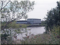
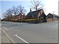

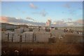
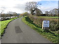
100 photos from this area
Area Information
Key information about the CH4 8RH including its size, population, and administrative classification.
- Area Type
- Postcode
- Area Size
- 34.4 hectares
- Population
- 1826
- Population Density
- 111 people/km²
House Prices in CH4 8RH
23
Properties
-
Average Sold Price
-
Lowest Price
-
Highest Price
Showing 23 properties
| Address | Type | Beds | Baths | Last Sale Price | Last Sale Date | |
|---|---|---|---|---|---|---|
| M S I, Viscount House, River Lane, Saltney, CH4 8RH | Office | - | - | - | - | |
| Toomey Skyway Leasing Ltd, Viscount House, River Lane, Saltney, CH4 8RH | Office | - | - | - | - | |
| Masons Print Group, Viscount House, River Lane, Saltney, CH4 8RH | Office | - | - | - | - | |
| 9, Communal Areas 2ND Floor, Viscount House, River Lane, Saltney, CH4 8RH | Office | - | - | - | - | |
| Suite 10 2ND Floor, Viscount House, River Lane, Saltney, CH4 8RH | Office | - | - | - | - | |
| Ls Tyres, Yard 5, River Lane, Saltney, CH4 8RH | Industrial | - | - | - | - | |
| First Floor 1, Viscount House, River Lane, Saltney, CH4 8RH | Office | - | - | - | - | |
| Land Used For Storage Adj, Britannia Driveways, River Lane, Saltney, CH4 8RH | Industrial | - | - | - | - | |
| First Floor 4, Viscount House, River Lane, Saltney, CH4 8RH | Office | - | - | - | - | |
| 8, First Floor, Viscount House, River Lane, Saltney, CH4 8RH | Office | - | - | - | - |
Page 1 of 3
Energy Efficiency in CH4 8RH
Amenities
Schools
| Rank | School | Type | Entry gender | Ages |
|---|
Explore more schools in this area
Go to Schools tabDemographics
Household Size
Family (3-5 people)
most common
Accommodation Type
Houses
most common
Tenure
69
majority
Ethnic Group
White
most common
Religion
N/A
most common
Household Composition
N/A
most common
Age
47
median
Adults (30-64 years)
most common
Household Deprivation
N/A
with no deprivation
NS-SEC
32
in Lower managerial occupations
Explore more demographic insights in this area
Go to Demographics tabPlanning
Planning Constraints
- Flood RiskPremium
- Ramsar Wetland SitesPremium
- Area of Outstanding Natural BeautyPremium
- Protected Nature ReservePremium
- Protected WoodlandPremium
- Crime RiskPremium