Area Overview for Brynford Community
Photos of Brynford Community

Area Information
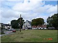
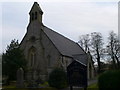
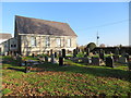
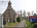
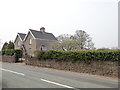
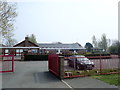
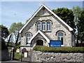
Brynford Community sits as a civil parish in Flintshire, Wales, covering an area of 8.7 km². This location lies to the south west of Holywell and remains close to the A55 North Wales Expressway. The area includes the villages of Calcoed and Dolphin, contributing to a small footprint for a designated community. Historical records indicate that the parish was created in 1897 and elects ten councillors. The landscape bears the scars of extensive historical lead mining which affected the common land. St Michael's Church, a Grade II listed building dating from 1851, stands as a central landmark. Nearby Calcoed hosts the Cynfaen Memorial Methodist Chapel. Archaeological interest remains high due to two Bronze Age round barrows known as Clwt Militia located on Holywell Golf Club, approximately 0.65 miles north-northwest of the church. Explorer Henry Morton Stanley was once a student teacher at the old village school. While the 2011 census recorded a population of 1,059, other figures suggest a total of approximately 2,106. Living in Brynford offers proximity to the A55 while maintaining a distinct village character.
- Area Type
- Parish
- Area Size
- 8.7 km²
- Population
- Not available
- Population Density
- Not available
Demographics
The demographic profile of Brynford Community reveals a distinctly older population. The median age sits at 70 years, marking a significant proportion of the residents as seniors. The most common age range category provided in the data relates to the total age group rather than a specific youthful bracket. Home ownership stands at eighty one percent, indicating that the vast majority of households own their properties outright or with a mortgage. This high ownership rate contrasts sharply with typical rental markets found in larger urban centres. The area does not prominently feature young professional families compared to its elderly demographic. Accommodation types generally reflect the needs of an older population, though specific breakdowns by structure are not detailed in the current figures. Ethnic diversity data is available only as a total category without further granular splits. Religious affiliation is similarly reported only as a total count without denominational specifics. The community composition suggests stability with little transient population movement. Families or individuals looking for retirement living or downsizing options will find the age profile here particularly relevant.
Household Size
Accommodation Type
Tenure
Ethnic Group
Religion
Household Composition
Age
Household Deprivation
NS-SEC
Explore more demographic insights in this area
Go to Demographics tabPlanning
Planning Constraints
- Flood RiskPremium
- Ramsar Wetland SitesPremium
- Area of Outstanding Natural BeautyPremium
- Protected Nature ReservePremium
- Protected WoodlandPremium
- Crime RiskPremium