Area Overview for Ynysawdre Community
Photos of Ynysawdre Community


Area Information
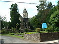
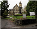
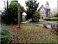
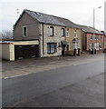
Ynysawdre Community is a compact civil parish located within Bridgend County Borough in south Wales. This area, covering exactly 1.9 square kilometres, comprises the villages of Tondu and Brynmenyn. You can find a section of Tondu commonly referred to by the community name, placing it east of Aberkenfig. The location sits near the latitude and longitude coordinates of 51.554183, -3.576459, within the CF32 postcode area. The community council has been managing local affairs since the Local Government Act 1894, ensuring a long-established governance structure for residents. Your daily life here is shaped by significant industrial heritage, including the rare Tondu Ironworks. You will encounter surviving calcining and coking kilns and 1920s horse-drawn railway bridges at Aberkenfig and Glan-Rhyd. These features provide a tangible link to the past while you navigate modern services. Your immediate surroundings include Pandy Park, which hosts football and rugby pitches for local teams like Tondu RFC. You also have access to the Ynysawdre Pool and Fitness Centre on Heol-Yr-Ysgol for recreation. The Ynysawdre Parish Hall, built circa 1924, serves as another historic anchor for community gatherings. Living in Ynysawdre Community means balancing a small-town village atmosphere with proximity to larger amenities in the larger settlement of Tondu. The demographic profile of Ynysawdre Community reflects an established, older population structure. The median age of residents is 70 years, indicating that a substantial portion of the population belongs to the senior demographic. The most common age range数据显示 as 'Total', which suggests the data aggregates across all age brackets without specific breakdowns for sub-groups. You will find that 65% of households are owner-occupied, demonstrating a high level of residential stability within the parish. Home ownership figures like this typically outpace rental markets in established rural Welsh communities. The accommodation type data is recorded as 'Total', meaning specific splits between detached, semi-detached, or terraced housing are not separately itemised in this dataset. The predominant ethnic group is listed as 'Total', indicating that detailed ethnicity breakdowns are available only as an aggregate figure. Religion data is similarly recorded as 'Total'. While the median age suggests a quiet, slower pace of life, the high home ownership rate implies that many residents have settled permanently. You should expect a neighbourhood where long-term families are a core component of the social fabric. The specific age composition skews heavily upwards compared to the national average for England and Wales. The housing market in Ynysawdre Community is defined by a strong presence of owner-occupied properties. You will find that 65% of households own their homes outright, pointing towards a market where families have settled for the long term rather than viewing housing as a transient rental asset. This high ownership percentage is characteristic of smaller parishes in rural Wales. The accommodation type data is listed as 'Total', which means specific census-like breakdowns between house styles are summarised in the primary dataset. However, the inclusion of residential facilities such as the Ynysawdre Pool and Fitness Centre on Heol-Yr-Ysgol suggests a supportive environment for multi-generational living. You may encounter properties associated with the village green or prescribed open spaces if searching near Pandy Park. The historical context of the area, including the former sites of the Tondu Ironworks, may influence the character of older residential addresses. Buying here often means entering a market with established boundaries and a clear sense of place. The villages of Tondu and Brynmenyn offer distinct micro-communities within the 1.9 km² footprint. Prospective buyers should prepare for a property search that focuses on older stock or those recently adapted for modern living. The market dynamics are slower than in urban hubs, driven by the preferences of the 65% owner-occupier base. Digital connectivity in Ynysawdre Community meets the requirements for modern remote work and leisure. Your fixed broadband quality score is 99 out of 100, which classifies the service as excellent. This rating ensures you can stream high-definition video, attend virtual meetings, and access cloud services without significant interruption. Your mobile network quality score is 84 out of 100, indicating good coverage for voice calls and data usage across the parish. These scores mean you do not need to worry about connectivity issues while commuting to nearby Bermondsey offices or working from home in your garden. You can rely on a stable internet connection whether you are in the village of Tondu or Brynmenyn. For your daily commute, the parish is situated in the CF32 postcode area, facilitating easy access to broader road networks despite its rural setting. The presence of major transport infrastructure is implied by the historical horse-drawn railway bridges at Aberkenfig and Glan-Rhyd, though current rail services must be checked against current timetables for your specific route. The high broadband score suggests the area is not isolated from the digital economy. You can expect seamless connectivity for all your online needs, supporting both professional responsibilities and personal entertainment. Safety and environmental assessments for Ynysawdre Community reveal a generally calm living environment with specific planning considerations. The flood risk assessment shows a low risk level with a score of 5.51 out of 100, meaning the area is largely unaffected by significant flood frequency. This low score indicates you can build or maintain property with minimal concern for water damage. The crime risk assessment is not available for this specific location as data is currently restricted to areas in England. You must rely on general community presence and local policing for crime-related security. Regarding planning constraints, there is no coverage for Ramsar wetland sites, Areas of Outstanding Natural Beauty, or protected nature reserves within the parish boundaries. These zero-score assessments mean no major statutory designations restrict development in those specific categories. However, the protected woodland assessment carries a warning level with a score of 7.79 out of 100. This score indicates the area contains protected woodland that you must consider if planning extensions or landscaping. This assessment does not imply high risk, but rather highlights an environmental asset that requires careful stewardship. The low flood risk combined with the absence of major planning constraints for sensitive habitats suggests a stable environment for homeowners. Is Ynysawdre Community suitable for families looking to settle down?Ynysawdre Community offers a stable environment with a 65% home ownership rate, indicating that many families plan to stay for the long term. The area includes Coleg Cymunedol Y Dderwen, an English-medium comprehensive school, and Brynmenyn Primary School to support education needs. Local amenities like Pandy Park provide football and rugby pitches for children, while the Ynysawdre Pool and Fitness Centre caters to all ages. The median age of 70 suggests a mature community rather than a family wasteland, but the presence of schools and parks indicates ongoing family residence within the villages of Tondu and Brynmenyn. How good is the internet connection for working from home?You will find excellent connectivity for remote work. The fixed broadband quality score is 99 out of 100, ensuring reliable high-speed internet for video calls and large file transfers. Your mobile network quality score stands at 84 out of 100, providing good coverage for voice and data across the 1.9 km² area. These high scores mean you can work from your home in either Tondu or Brynmenyn without interruption from connectivity issues, meeting the demands of modern digital lifestyles. Are there any environmental risks I should be aware of when buying here?The primary environmental consideration is the presence of protected woodland, which registers a warning level assessment with a score of 7.79. This means you must check planning permissions carefully if you intend to build or significantly alter land near these woods. Otherwise, the area has a low flood risk score of 5.51 and no Ramsar wetland or AONB restrictions. The lack of major planning constraints usually simplifies the buying process for typical residential properties in this parish. What is the demographic feel of the village?The community is older, with a median age of 70 years. This suggests a quieter, slower-paced environment compared to larger towns. The 65% home ownership rate reinforces this as a place where people establish permanent homes rather than transient rentals. While the population is skewed towards seniors, the presence of infant schools and sports facilities like those at Pandy Park shows that the village still supports younger families within its villages of Tondu and Brynmenyn.
- Area Type
- Parish
- Area Size
- 1.9 km²
- Population
- Not available
- Population Density
- Not available
Demographics
The demographic profile of Ynysawdre Community reflects an established, older population structure. The median age of residents is 70 years, indicating that a substantial portion of the population belongs to the senior demographic. The most common age range数据显示 as 'Total', which suggests the data aggregates across all age brackets without specific breakdowns for sub-groups. You will find that 65% of households are owner-occupied, demonstrating a high level of residential stability within the parish. Home ownership figures like this typically outpace rental markets in established rural Welsh communities. The accommodation type data is recorded as 'Total', meaning specific splits between detached, semi-detached, or terraced housing are not separately itemised in this dataset. The predominant ethnic group is listed as 'Total', indicating that detailed ethnicity breakdowns are available only as an aggregate figure. Religion data is similarly recorded as 'Total'. While the median age suggests a quiet, slower pace of life, the high home ownership rate implies that many residents have settled permanently. You should expect a neighbourhood where long-term families are a core component of the social fabric. The specific age composition skews heavily upwards compared to the national average for England and Wales. The housing market in Ynysawdre Community is defined by a strong presence of owner-occupied properties. You will find that 65% of households own their homes outright, pointing towards a market where families have settled for the long term rather than viewing housing as a transient rental asset. This high ownership percentage is characteristic of smaller parishes in rural Wales. The accommodation type data is listed as 'Total', which means specific census-like breakdowns between house styles are summarised in the primary dataset. However, the inclusion of residential facilities such as the Ynysawdre Pool and Fitness Centre on Heol-Yr-Ysgol suggests a supportive environment for multi-generational living. You may encounter properties associated with the village green or prescribed open spaces if searching near Pandy Park. The historical context of the area, including the former sites of the Tondu Ironworks, may influence the character of older residential addresses. Buying here often means entering a market with established boundaries and a clear sense of place. The villages of Tondu and Brynmenyn offer distinct micro-communities within the 1.9 km² footprint. Prospective buyers should prepare for a property search that focuses on older stock or those recently adapted for modern living. The market dynamics are slower than in urban hubs, driven by the preferences of the 65% owner-occupier base. Digital connectivity in Ynysawdre Community meets the requirements for modern remote work and leisure. Your fixed broadband quality score is 99 out of 100, which classifies the service as excellent. This rating ensures you can stream high-definition video, attend virtual meetings, and access cloud services without significant interruption. Your mobile network quality score is 84 out of 100, indicating good coverage for voice calls and data usage across the parish. These scores mean you do not need to worry about connectivity issues while commuting to nearby Bermondsey offices or working from home in your garden. You can rely on a stable internet connection whether you are in the village of Tondu or Brynmenyn. For your daily commute, the parish is situated in the CF32 postcode area, facilitating easy access to broader road networks despite its rural setting. The presence of major transport infrastructure is implied by the historical horse-drawn railway bridges at Aberkenfig and Glan-Rhyd, though current rail services must be checked against current timetables for your specific route. The high broadband score suggests the area is not isolated from the digital economy. You can expect seamless connectivity for all your online needs, supporting both professional responsibilities and personal entertainment. Safety and environmental assessments for Ynysawdre Community reveal a generally calm living environment with specific planning considerations. The flood risk assessment shows a low risk level with a score of 5.51 out of 100, meaning the area is largely unaffected by significant flood frequency. This low score indicates you can build or maintain property with minimal concern for water damage. The crime risk assessment is not available for this specific location as data is currently restricted to areas in England. You must rely on general community presence and local policing for crime-related security. Regarding planning constraints, there is no coverage for Ramsar wetland sites, Areas of Outstanding Natural Beauty, or protected nature reserves within the parish boundaries. These zero-score assessments mean no major statutory designations restrict development in those specific categories. However, the protected woodland assessment carries a warning level with a score of 7.79 out of 100. This score indicates the area contains protected woodland that you must consider if planning extensions or landscaping. This assessment does not imply high risk, but rather highlights an environmental asset that requires careful stewardship. The low flood risk combined with the absence of major planning constraints for sensitive habitats suggests a stable environment for homeowners. Is Ynysawdre Community suitable for families looking to settle down?Ynysawdre Community offers a stable environment with a 65% home ownership rate, indicating that many families plan to stay for the long term. The area includes Coleg Cymunedol Y Dderwen, an English-medium comprehensive school, and Brynmenyn Primary School to support education needs. Local amenities like Pandy Park provide football and rugby pitches for children, while the Ynysawdre Pool and Fitness Centre caters to all ages. The median age of 70 suggests a mature community rather than a family wasteland, but the presence of schools and parks indicates ongoing family residence within the villages of Tondu and Brynmenyn. How good is the internet connection for working from home?You will find excellent connectivity for remote work. The fixed broadband quality score is 99 out of 100, ensuring reliable high-speed internet for video calls and large file transfers. Your mobile network quality score stands at 84 out of 100, providing good coverage for voice and data across the 1.9 km² area. These high scores mean you can work from your home in either Tondu or Brynmenyn without interruption from connectivity issues, meeting the demands of modern digital lifestyles. Are there any environmental risks I should be aware of when buying here?The primary environmental consideration is the presence of protected woodland, which registers a warning level assessment with a score of 7.79. This means you must check planning permissions carefully if you intend to build or significantly alter land near these woods. Otherwise, the area has a low flood risk score of 5.51 and no Ramsar wetland or AONB restrictions. The lack of major planning constraints usually simplifies the buying process for typical residential properties in this parish. What is the demographic feel of the village?The community is older, with a median age of 70 years. This suggests a quieter, slower-paced environment compared to larger towns. The 65% home ownership rate reinforces this as a place where people establish permanent homes rather than transient rentals. While the population is skewed towards seniors, the presence of infant schools and sports facilities like those at Pandy Park shows that the village still supports younger families within its villages of Tondu and Brynmenyn.
Household Size
Accommodation Type
Tenure
Ethnic Group
Religion
Household Composition
Age
Household Deprivation
NS-SEC
Explore more demographic insights in this area
Go to Demographics tabPlanning
Planning Constraints
- Flood RiskPremium
- Ramsar Wetland SitesPremium
- Area of Outstanding Natural BeautyPremium
- Protected Nature ReservePremium
- Protected WoodlandPremium
- Crime RiskPremium