Area Overview for Ogmore Valley Community
Photos of Ogmore Valley Community


Area Information
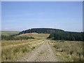
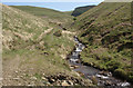
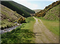
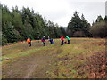
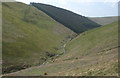
Living in Ogmore Valley Community means embracing a settled life within a parish roughly 38.5 square kilometres in size. You will find yourself nestled between the basins of the Ogwr Fawr and Ogwr Fach rivers, surrounded by the villages of Ogmore Vale, Nantymoel, Price Town, and Wyndham. This area carries a distinct history as a former coal mining zone that only began significant development in 1865 when the Ogmore Valley Railway opened. John Brogden and Sons facilitated this growth, establishing collieries such as Aber, Caedu, Tynewydd, and Wyndham which drove rapid expansion from a population of under 100 in 1851. By 2011, the local census recorded a population of 7,954. Today, the community retains its character as a valley settlement that transitioned from quiet rural hill farming before 1865 to a populated residential area. The postcode CF32 7BN serves Ogmore Vale, your likely point of entry to this historic hub. You are entering a place defined by its industrial roots and its evolution into a stable civil parish within Bridgend County Borough. The landscape is still shaped by the legacy of high-quality house, bituminous, and smokeless steam coals that were once extracted here. While major commercial centres are no longer the dominant feature, the area remains a cohesive community. Your daily rhythm here is influenced by this deep local history and the specific geography of the River Ogmore valley. Knowing the background of places like Wye Valley or broader Connah's Quay helps contextualise this unique Welsh valley environment.
- Area Type
- Parish
- Area Size
- 38.5 km²
- Population
- Not available
- Population Density
- Not available
Demographics
The people of Ogmore Valley Community reflect a settled population with a median age of 70 years. This demographic profile indicates that the area attracts residents seeking retirement or stability rather than high-energy urban environments. You are likely to encounter a community where a significant proportion of the population falls into later life stages. Home ownership stands at 68 per cent, suggesting that most residents have stayed long term or purchased properties to build lasting roots. This high ownership rate contrasts sharply with rental-dominant zones and signals a stable housing environment. The census data from 2011 supports these figures, backing the demographic trends you would expect here. While specific data on household composition and ethnic diversity is not detailed in the provided records, the high home ownership and older median age define the social fabric. You will find that the majority of homes are owned outright by residents who prioritise stability. The area does not show signs of high transient populations, which often characterise student hubs or commuter belts. Instead, the social dynamic revolves around established families and retirees who know their neighbours. The 68 per cent ownership figure is a concrete fact that shapes your expectation of community engagement. You can approach this area expecting a quiet, dependable neighbourhood where people value their homes and local connections over rapid relocation.
Household Size
Accommodation Type
Tenure
Ethnic Group
Religion
Household Composition
Age
Household Deprivation
NS-SEC
Explore more demographic insights in this area
Go to Demographics tabPlanning
Planning Constraints
- Flood RiskPremium
- Ramsar Wetland SitesPremium
- Area of Outstanding Natural BeautyPremium
- Protected Nature ReservePremium
- Protected WoodlandPremium
- Crime RiskPremium