Area Overview for Llangynwyd Lower Community
Photos of Llangynwyd Lower Community
Area Information
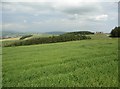
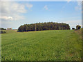
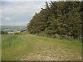
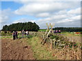
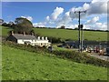
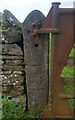
Living in Llangynwyd Lower Community offers a distinct residential experience within the Bridgend County Borough of south Wales. This civil parish forms the southern part of the historic Llangynwyd area, situated north-west of the town of Bridgend. The community spans 8.9 km², encompassing sparsely populated hilly farmland that characterises the landscape. The River Llynfi borders the area to the east, while a woodland valley lines the western boundary. Major transport links include the A4063 road, which marks the eastern perimeter. Residents enjoy proximity to significant historical landmarks, including Llangynwyd Castle, a Scheduled Ancient Monument that once served as a strategic base for the medieval lordship of Tir Iarll. The parish was established through government reorganisation in 1974, replacing earlier administrative boundaries. Today, the population remains steady yet small, reflecting a rural settlement rhythm. For those seeking homes in this parish, life involves navigating rolling hills and open farmland rather than dense urban infrastructure. The setting provides a quiet environment rooted in deep historical significance, from the early medieval church site of St Cynwyd to archaeological remains dating back to the Iron Age or Roman times. This location appeals to individuals who value a connection to heritage while maintaining access to modern transport routes like the A4063.
- Area Type
- Parish
- Area Size
- 8.9 km²
- Population
- Not available
- Population Density
- Not available
Demographics
The community demographic profile reveals a mature population with a median age of 70 years. This figure indicates that the area is populated primarily by older residents. Many households in Llangynwyd Lower Community consist of individuals or couples in later life stages. Home ownership stands at an impressive 79%, meaning most properties are owned outright or have mortgages without rental obligations. Nearly 80 of every 100 homes fall under this ownership category. The high ownership rate suggests a stable community where long-term residents maintain their properties. Accommodation types reflect this stability, with few properties available on the private rental market. Diversity data indicates the predominant ethnic group within the parish aligns with the national baseline for rural Wales, though specific breakdowns are not detailed in current records. The total household composition mirrors a settlement where shared living arrangements among families with young children or large multi-generational homes are less common than single-occupancy or couple-based households. The age profile confirms this is a retirement or semi-retirement destination rather than a hub for young professionals or students. Despite the mature age structure, the community remains functionally active with residents managing countryside estates and historic sites. The 79% ownership figure provides security for buyers entering the market, as they are likely purchasing from willing sellers rather than facing complex leasehold restrictions common in other parts of Wales.
Household Size
Accommodation Type
Tenure
Ethnic Group
Religion
Household Composition
Age
Household Deprivation
NS-SEC
Explore more demographic insights in this area
Go to Demographics tabPlanning
Planning Constraints
- Flood RiskPremium
- Ramsar Wetland SitesPremium
- Area of Outstanding Natural BeautyPremium
- Protected Nature ReservePremium
- Protected WoodlandPremium
- Crime RiskPremium