Area Overview for CF34 9PW
Photos of CF34 9PW


Area Information
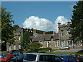
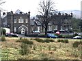
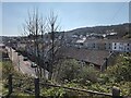
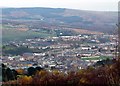
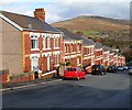
CF34 9PW, a small postcode area in Wales, sits within the Llynfi Valley of Bridgend County Borough. With a population of 1,465, it is a compact residential cluster shaped by its industrial past and evolving into a quiet community. The area’s name, derived from Welsh for “fair field,” hints at its historical roots in agriculture before the 19th-century ironworks and coal mines transformed it. Today, CF34 9PW serves as a dormitory for nearby cities like Port Talbot, Bridgend, and Cardiff, with its character defined by a blend of Victorian architecture and remnants of its industrial heritage. The Town Hall, opened in 1881, remains a focal point, reflecting the area’s communal spirit. Daily life here is anchored by local amenities, including shops and rail links, while the landscape offers a mix of valleys and high mountains. Though the economy has shifted from iron and coal to reliance on nearby employment hubs, the area retains a distinct identity rooted in its history. For buyers, CF34 9PW offers a sense of stability, with a predominantly home-owning population and low environmental risks, making it a practical choice for those seeking a quieter, established community.
- Area Type
- Postcode
- Area Size
- Not available
- Population
- 1465
- Population Density
- 1788 people/km²
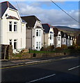
The property market in CF34 9PW is dominated by owner-occupied homes, with 84% of residents living in properties they own. The area’s accommodation type is primarily houses, reflecting a preference for single-family residences over flats or apartments. This makes CF34 9PW a small, stable market with limited rental activity, as the majority of properties are held by long-term owners. The high home ownership rate suggests a community with a strong sense of place, where properties are likely to be well-maintained and retain value over time. However, the small size of the area means the housing stock is finite, and buyers may face competition for available homes. The presence of historic buildings, such as the 1881 Town Hall and blast furnace remnants, adds unique character but may also mean properties require renovation. For buyers, this area offers a chance to invest in a quiet, established community with a distinct industrial heritage, though the market’s size limits options for those seeking a wide range of properties.
House Prices in CF34 9PW
No properties found in this postcode.
Energy Efficiency in CF34 9PW
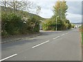
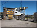
Living in CF34 9PW offers a blend of convenience and quiet charm, with nearby amenities within practical reach. Retail options include Tesco Maesteg, Iceland Maesteg, and Aldi Garth, providing essential shopping for daily needs. The area’s rail network, with stations like Maesteg and Garth, connects residents to broader transport routes, though specific details on local bus services are not provided. The Maesteg Market, held in the Town Hall since 1881, adds a touch of tradition to the community’s retail scene. For leisure, the Maesteg Sports Centre features historic elements like blast furnace remnants, offering a unique link to the area’s industrial past. While parks and green spaces are not explicitly detailed, the valley’s natural surroundings suggest opportunities for outdoor activities. The lifestyle here balances practicality with a sense of history, making it suitable for those who value accessibility without sacrificing a connection to the past.
Amenities
Schools
| Rank | School | Type | Entry gender | Ages |
|---|
Explore more schools in this area
Go to Schools tabDemographics
The community in CF34 9PW is predominantly middle-aged and older, with a median age of 47 and the most common age range being 30–64 years. This suggests a population largely composed of established professionals and families, with fewer younger residents. Home ownership is high at 84%, indicating a stable, long-term resident base. The area is characterised by houses rather than flats, reflecting a preference for single-family living. The predominant ethnic group is White, though specific data on diversity or deprivation is not provided. The age profile implies a community with mature needs, such as access to healthcare and retirement planning, but also a workforce experienced in industries like manufacturing and mining, which historically shaped the area. The high home ownership rate and older demographic suggest a low turnover of properties, which can be advantageous for buyers seeking long-term investment. However, it also means the housing stock is largely fixed, with limited new developments.
Household Size
Accommodation Type
Tenure
Ethnic Group
Religion
Household Composition
Age
Household Deprivation
NS-SEC
Explore more demographic insights in this area
Go to Demographics tabPlanning
Planning Constraints
- Flood RiskPremium
- Ramsar Wetland SitesPremium
- Area of Outstanding Natural BeautyPremium
- Protected Nature ReservePremium
- Protected WoodlandPremium
- Crime RiskPremium