Area Overview for CF31 1JA
Photos of CF31 1JA


Area Information
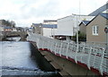
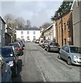
CF31 1JA is a small residential cluster in Bridgend County Borough, Wales, centred on the historic medieval settlement along the River Ogmore. With a population of 1,607, it reflects a tight-knit community shaped by its roots in the former Ewenny community and Bridgend’s role as a market town since the 15th century. The area’s compact size means daily life is characterised by proximity to amenities such as retail outlets, rail stations, and the River Ogmore itself. Residents benefit from a mix of historical heritage and modern infrastructure, with nearby Bridgend Railway Station offering connections to larger towns. The median age of 47 suggests a mature demographic, with many households established in the area for decades. While the postcode covers a limited geographical footprint, its strategic location within Bridgend County Borough provides access to broader regional opportunities. For those seeking a quiet, historically rich environment with practical connectivity, CF31 1JA offers a blend of tradition and convenience.
- Area Type
- Postcode
- Area Size
- Not available
- Population
- 1607
- Population Density
- 3741 people/km²
The property market in CF31 1JA is defined by a 50% home ownership rate, with houses forming the primary accommodation type. This suggests a mix of owner-occupied and rental properties, though the small area size means the housing stock is limited. The focus on houses rather than flats or apartments indicates a preference for traditional, family-friendly homes. For buyers, this means the market is likely to be tight, with limited new developments and a reliance on existing properties. The area’s proximity to Bridgend’s rail network may appeal to commuters, but the small postcode area means buyers must consider nearby neighbourhoods for more options. The lack of high-rise or modern housing also means the character of the area remains rooted in its historical context.
House Prices in CF31 1JA
No properties found in this postcode.
Energy Efficiency in CF31 1JA
The lifestyle in CF31 1JA is shaped by its proximity to retail and transport hubs. Nearby shops include Spar, Tesco Bridgend, and Iceland Bridgend, offering everyday essentials within easy reach. The rail network, with stations such as Bridgend and Sarn, provides access to larger towns for leisure, dining, and shopping. While the area itself has limited amenities, its small size means residents can access a range of services without long commutes. The River Ogmore, a historical feature of the settlement, may offer recreational opportunities, though specific parks or leisure facilities are not detailed in the data. The balance of local convenience and regional connectivity supports a practical, community-oriented lifestyle.
Amenities
Schools
The nearest school to CF31 1JA is Penybont Primary School, categorised as an 'other' type. No Ofsted rating is provided in the data, so its educational standards cannot be assessed directly. As a primary school, it serves the local community, but the absence of secondary schools or additional educational institutions within the area means families may need to look beyond CF31 1JA for comprehensive schooling. The single primary school highlights the importance of nearby towns like Bridgend for secondary education. For parents prioritising proximity to schools, the area’s limited options should be considered alongside the broader regional network.
| Rank | School | Type | Entry gender | Ages |
|---|
Explore more schools in this area
Go to Schools tabDemographics
The population of CF31 1JA is 1,607, with a median age of 47. The most common age range is adults aged 30–64, indicating a stable, middle-aged community. Home ownership stands at 50%, with houses being the predominant accommodation type. The predominant ethnic group is White, reflecting the area’s demographic composition. This suggests a largely settled population with long-term residency patterns. The absence of specific deprivation data means the area’s quality of life cannot be assessed through socioeconomic indicators, but the balance of home ownership and age profile points to a community focused on stability and family life. The small population size also implies a close-knit environment where social ties may be strong.
Household Size
Accommodation Type
Tenure
Ethnic Group
Religion
Household Composition
Age
Household Deprivation
NS-SEC
Explore more demographic insights in this area
Go to Demographics tabPlanning
Planning Constraints
- Flood RiskPremium
- Ramsar Wetland SitesPremium
- Area of Outstanding Natural BeautyPremium
- Protected Nature ReservePremium
- Protected WoodlandPremium
- Crime RiskPremium