Area Overview for LS28 5JQ
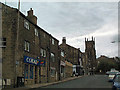
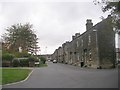
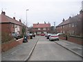
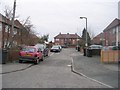
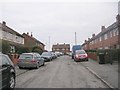
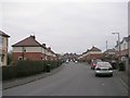
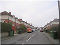
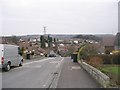
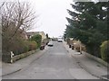
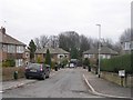
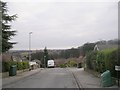
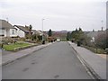
Photos of LS28 5JQ
Area Information
LS28 5JQ is a small residential postcode in west Leeds, covering 2,371 square metres and home to 1,612 people. Its population density of 679,833 people per square kilometre reflects a compact, closely knit community. Situated in the Calverley and Farsley ward, this area is historically rooted, with landmarks like Calverley Old Hall, a 14th-century manor house, and Calverley Cutting, a 19th-century road carved through sandstone. The village lies on the A657, approximately 10 miles from Leeds city centre and four miles from Bradford. Daily life here is shaped by its proximity to retail hubs like Co-op Farsley and Asda Pudsey, as well as rail links to New Pudsey and Bramley stations. The area’s mix of historical architecture and modern infrastructure makes it appealing for those seeking a balance between tradition and convenience. With a median age of 47 and a population skewed toward adults aged 30–64, the community is stable, with a strong emphasis on home ownership. This is a place where heritage meets practicality, offering a quiet alternative to larger urban centres.
- Area Type
- Postcode
- Area Size
- 2371 m²
- Population
- 1612
- Population Density
- 4291 people/km²
LS28 5JQ is a predominantly owner-occupied area, with 66% of residents owning their homes. The accommodation type is primarily houses, which suggests a focus on family homes and larger properties. This contrasts with areas dominated by flats or rental properties, indicating a community that values long-term residency and property investment. The small size of the postcode means the housing stock is limited, and buyers should consider the immediate surrounding areas for more options. The high home ownership rate implies strong local ties, though the absence of specific data on property prices or market trends means buyers must conduct further research. Given the area’s historical character and proximity to retail and transport hubs, it may appeal to those seeking a balance between residential tranquillity and accessibility to urban amenities.
House Prices in LS28 5JQ
Showing 6 properties
| Address | Type | Beds | Baths | Last Sale Price | Last Sale Date | |
|---|---|---|---|---|---|---|
| 3 Edroyd Place, Farsley, Pudsey, LS28 5JQ | Terraced | 2 | 1 | £216,000 | Jul 2024 | |
| 4 Edroyd Place, Farsley, Pudsey, LS28 5JQ | Terraced | 2 | 1 | £219,000 | Apr 2024 | |
| 1 Edroyd Place, Farsley, Pudsey, LS28 5JQ | Terraced | 2 | - | £130,000 | Apr 2021 | |
| 8 Edroyd Place, Farsley, Pudsey, LS28 5JQ | house | - | - | £57,995 | Apr 1998 | |
| 6 Edroyd Place, Farsley, Pudsey, LS28 5JQ | Terraced | - | - | - | - | |
| Alma House, 2 Edroyd Place, Farsley, Pudsey, LS28 5JQ | house | - | - | - | - |
Energy Efficiency in LS28 5JQ
Residents of LS28 5JQ have access to essential amenities within practical reach. Retail options include Co-op Farsley, Asda Pudsey, and Lidl Bramley, providing everyday shopping convenience. Rail stations at New Pudsey and Bramley offer connections to nearby towns and cities, while the A657 road facilitates travel to larger centres. The area’s proximity to Leeds Bradford Airport (dubbed twice in the data) adds to its appeal for those requiring air travel. Though specific parks or leisure facilities are not detailed, the historical landmarks of Calverley Old Hall and Calverley Cutting suggest a blend of heritage and natural features. The compact nature of the postcode means residents may rely on nearby towns for broader amenities, but the existing infrastructure supports a self-contained lifestyle with minimal need to travel far for essentials.
Amenities
Schools
| Rank | School | Type | Entry gender | Ages |
|---|
Explore more schools in this area
Go to Schools tabDemographics
The population of LS28 5JQ has a median age of 47, with the majority of residents falling within the 30–64 age range. Home ownership is high at 66%, and the area is predominantly composed of houses, reflecting a family-oriented demographic. The predominant ethnic group is White, accounting for the majority of the population. Contextualising deprivation, the broader Calverley and Farsley ward has 81.9% of its population in the mid-range of deprivation, which suggests that while basic needs are generally met, there may be limitations in access to higher-tier services or amenities. This data implies that quality of life here is moderate, with residents likely relying on nearby towns for more specialised resources. The age profile indicates a mature community, potentially with established local networks and a focus on stability over rapid change.
Household Size
Accommodation Type
Tenure
Ethnic Group
Religion
Household Composition
Age
Household Deprivation
NS-SEC
Explore more demographic insights in this area
Go to Demographics tabPlanning
Planning Constraints
- Flood RiskPremium
- Ramsar Wetland SitesPremium
- Area of Outstanding Natural BeautyPremium
- Protected Nature ReservePremium
- Protected WoodlandPremium