Area Overview for LS28 5JH
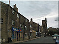
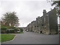
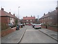
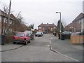
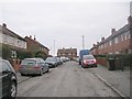
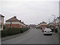
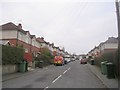
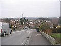
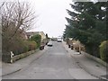
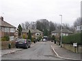
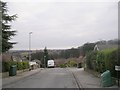
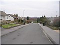
Photos of LS28 5JH
Area Information
LS28 5JH is a small, densely populated residential postcode in west Leeds, covering 6,167 square metres and home to 1,612 residents. Its compact size and high population density of 261,387 people per square kilometre reflect a tightly knit community. The area is part of the Calverley and Farsley ward, a historically significant electoral district with roots in medieval times. Calverley Old Hall, a 14th-century manor house, stands as a notable landmark, while the A657 road runs through the village, linking it to nearby towns. Daily life here is shaped by its rural character, with a mix of traditional housing and modern infrastructure. The area’s proximity to Leeds and Bradford—just 16 km and 7 km respectively—offers commuters access to urban amenities without sacrificing the quiet of a smaller settlement. The ward’s history, including the 1605 tragedy at Calverley Hall, adds depth to its identity, though contemporary life is defined by practical needs: retail, transport, and community safety.
- Area Type
- Postcode
- Area Size
- 6167 m²
- Population
- 1612
- Population Density
- 4291 people/km²
The property market in LS28 5JH is characterised by a strong emphasis on owner-occupation, with 66% of homes owned by residents rather than rented. The area is predominantly composed of houses, which aligns with its suburban, low-density layout. This contrasts with larger cities where flats dominate, suggesting a preference for family-friendly, standalone properties. The high home ownership rate indicates a community of long-term residents, many of whom may have built equity over decades. For buyers, this means a market with fewer rental properties and a focus on purchasing rather than leasing. The small area size and proximity to transport links like the A657 road and nearby rail stations make it appealing for those seeking a balance between rural tranquillity and urban accessibility. However, the limited number of properties (only 1,612 residents) means competition for available homes could be intense.
House Prices in LS28 5JH
Showing 8 properties
| Address | Type | Beds | Baths | Last Sale Price | Last Sale Date | |
|---|---|---|---|---|---|---|
| 10 High Bank Street, Farsley, Pudsey, LS28 5JH | Terraced | 3 | 2 | £360,000 | Jul 2024 | |
| 4 High Bank Street, Farsley, Pudsey, LS28 5JH | Terraced | 3 | 2 | £265,000 | Jan 2024 | |
| 21 High Bank Street, Farsley, Pudsey, LS28 5JH | Terraced | 3 | - | £172,000 | Jun 2015 | |
| 8 High Bank Street, Farsley, Pudsey, LS28 5JH | Terraced | 2 | 1 | £150,000 | Jul 2013 | |
| 6 High Bank Street, Farsley, Pudsey, LS28 5JH | Terraced | - | - | £215,000 | Nov 2007 | |
| 12 High Bank Street, Farsley, Pudsey, LS28 5JH | Terraced | - | - | £166,750 | Mar 2005 | |
| 23 High Bank Street, Farsley, Pudsey, LS28 5JH | Terraced | - | - | - | - | |
| 2 High Bank Street, Farsley, Pudsey, LS28 5JH | Terraced | - | - | - | - |
Energy Efficiency in LS28 5JH
Residents of LS28 5JH have access to a range of nearby amenities, including five retail outlets such as Co-op Farsley, Asda Pudsey, and Lidl Bramley, ensuring everyday shopping needs are met. Three rail stations—New Pudsey, Bramley, and New Pudsey—provide regular connections to Leeds and Bradford, facilitating both commuting and travel. The area’s proximity to Leeds Bradford Airport (two airports within reach) adds convenience for frequent flyers. While specific details about parks or leisure facilities are not provided, the historical significance of Calverley Old Hall and the A657 road suggest a blend of heritage and practicality. The compact nature of the area means amenities are within walking or short driving distance, supporting a lifestyle that balances convenience with the quieter aspects of suburban living.
Amenities
Schools
| Rank | School | Type | Entry gender | Ages |
|---|
Explore more schools in this area
Go to Schools tabDemographics
The population of LS28 5JH has a median age of 47, with the majority (66%) of residents aged 30–64. Home ownership is high at 66%, and the area is predominantly composed of houses, reflecting a stable, long-term resident base. The ethnic composition is 80.8% White, with Asian communities making up 13.8% of the population. Deprivation levels in the broader Calverley and Farsley ward are notably high, with 81.9% of residents living in the mid-range of deprivation. This suggests limited access to certain services or opportunities compared to other parts of Leeds. However, the area’s safety profile—75/100 on a crime risk score—indicates a relatively secure environment for families and individuals. The demographic makeup and ownership rates suggest a community focused on stability, with fewer transient residents compared to more urban areas.
Household Size
Accommodation Type
Tenure
Ethnic Group
Religion
Household Composition
Age
Household Deprivation
NS-SEC
Explore more demographic insights in this area
Go to Demographics tabPlanning
Planning Constraints
- Flood RiskPremium
- Ramsar Wetland SitesPremium
- Area of Outstanding Natural BeautyPremium
- Protected Nature ReservePremium
- Protected WoodlandPremium