Area Overview for WS11 9QP
Photos of WS11 9QP

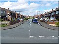

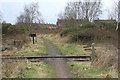
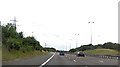
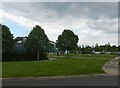

57 photos from this area
Area Information
Key information about the WS11 9QP including its size, population, and administrative classification.
- Area Type
- Postcode
- Area Size
- 1.3 hectares
- Population
- 2632
- Population Density
- 5153 people/km²
House Prices in WS11 9QP
46
Properties
£125,583
Average Sold Price
£63,500
Lowest Price
£262,500
Highest Price
Showing 46 properties
| Address | Type | Beds | Baths | Last Sale Price | Last Sale Date | |
|---|---|---|---|---|---|---|
| 68 Red Lion Lane, Norton Canes, Cannock, WS11 9QP | Terraced | 3 | 1 | £145,000 | Dec 2020 | |
| 88 Red Lion Lane, Norton Canes, Cannock, WS11 9QP | Detached | 4 | 2 | £262,500 | Jan 2018 | |
| 52 Red Lion Lane, Norton Canes, Cannock, WS11 9QP | Semi-detached | 3 | 1 | £153,000 | Oct 2017 | |
| 74 Red Lion Lane, Norton Canes, Cannock, WS11 9QP | Terraced | 3 | 1 | £120,000 | May 2016 | |
| 10 Red Lion Lane, Norton Canes, Cannock, WS11 9QP | house | 2 | 1 | £116,000 | Mar 2016 | |
| 80 Red Lion Lane, Norton Canes, Cannock, WS11 9QP | Terraced | 3 | 1 | £113,000 | Sep 2014 | |
| 32 Red Lion Lane, Norton Canes, Cannock, WS11 9QP | house | - | - | £120,000 | Nov 2012 | |
| 26 Red Lion Lane, Norton Canes, Cannock, WS11 9QP | house | - | - | £105,000 | Oct 2009 | |
| 14 Red Lion Lane, Norton Canes, Cannock, WS11 9QP | house | - | - | £105,000 | Aug 2006 | |
| 6 Red Lion Lane, Norton Canes, Cannock, WS11 9QP | Detached | 3 | 2 | £110,000 | Jan 2005 |
Page 1 of 5
Energy Efficiency in WS11 9QP
Amenities
Schools
| Rank | School | Type | Entry gender | Ages |
|---|
Explore more schools in this area
Go to Schools tabDemographics
Household Size
Family (3-5 people)
most common
Accommodation Type
Houses
most common
Tenure
58
majority
Ethnic Group
White
most common
Religion
N/A
most common
Household Composition
N/A
most common
Age
47
median
Adults (30-64 years)
most common
Household Deprivation
N/A
with no deprivation
NS-SEC
25
in Lower managerial occupations
Explore more demographic insights in this area
Go to Demographics tabPlanning
Planning Constraints
- Flood RiskPremium
- Ramsar Wetland SitesPremium
- Area of Outstanding Natural BeautyPremium
- Protected Nature ReservePremium
- Protected WoodlandPremium