Area Overview for Hodnet
Photos of Hodnet
Area Information
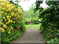
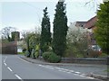
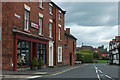
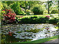
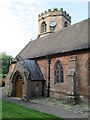
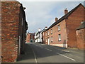
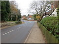
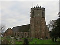
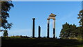
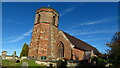
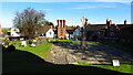
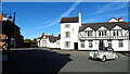
Living in Hodnet offers a distinctly rural life within Shropshire, defined by its historic roots and expansive countryside. This civil parish covers 38.9 square kilometres of fertile arable land characterised by rolling glacial landscapes and the flat flood plain of the River Tern. The settlement, once recorded as Odenet in the Domesday Book, sits approximately 5.7 miles south-west of Market Drayton on the A53 road. Today, you find yourself in a village with a picturesque feel among wooded valleys and peaceful valley contours. The area remains largely unchanged since 2011, with a population standing at 1,534 residents. Your daily rhythms will centre on a quiet lifestyle away from major urban hubs. The village features notable landmarks such as St Luke's Church, which dates back to the 12th century, and Hodnet Hall Gardens, developed in the 1920s around a neo-Elizabethan hall. These green spaces provide essential recreation within the community. The Bear Inn, a 16th-century coaching inn, anchors the high street, while the A53 Hodnet bypass, opened in 2003, directs heavy traffic away from the village centre. With coordinates around 52°51′11″N 2°34′33″W, the location balances isolation with access to Shrewsbury and Newcastle-under-Lyme. This blend of historic architecture, natural scenery, and low density defines the experience of residing in this Shropshire parish.
- Area Type
- Parish
- Area Size
- 38.9 km²
- Population
- Not available
- Population Density
- Not available
Demographics
The community profile of Hodnet reveals a settlement with a notably older population structure. The median age for residents stands at 70 years, indicating that the village is home to a significant number of older adults. While specific age range breakdowns beyond the total category are not detailed, the high median age suggests a demographic shift common in rural retirement destinations. You are likely to encounter neighbours who value established routines and community continuity over rapid change. Household composition data is recorded as a total figure without further segmentation, yet this demographic skew often influences how homes are shared or occupied locally. Home ownership represents the dominant living arrangement, with 75 per cent of homes owned outright or with a mortgage. This high rate of ownership typically correlates with longer-term residents who have built their lives into the area over generations. Accommodation types are recorded as a total without specific breakdowns, but the ownership rate implies a stock of family homes or retirement properties rather than student accommodation or high-density renting. Diversity and religious affiliation figures are noted as totals, indicating a general homogeneity typical of many English parishes. For those considering moving here, the environment caters primarily to individuals or couples seeking stability rather than transient urban professionals. The lack of a large youth population or significant rental sector shapes a calm, predictable social atmosphere where long-standing residents know their neighbours well.
Household Size
Accommodation Type
Tenure
Ethnic Group
Religion
Household Composition
Age
Household Deprivation
NS-SEC
Explore more demographic insights in this area
Go to Demographics tabPlanning
Planning Constraints
- Flood RiskPremium
- Ramsar Wetland SitesPremium
- Area of Outstanding Natural BeautyPremium
- Protected Nature ReservePremium
- Protected WoodlandPremium