Area Overview for Ellesmere Urban
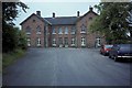
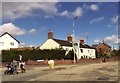
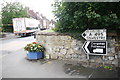
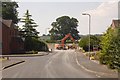
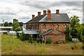
Photos of Ellesmere Urban


Area Information
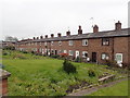
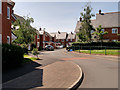
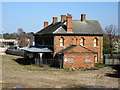
Living in Ellesmere Urban offers a distinct experience within a small civil parish covering 4.9 square kilometres. This compact area provides personalised surroundings for residents who prefer a settled environment. You will find a quiet setting that balances isolation with essential local amenities. The small geographical footprint means distances between home, garden, and nearby services remain manageable without needing a large car. Prospective buyers should note that the parish is established and defined by its rural character rather than urban sprawl. The community here has matured over time, creating a space where neighbours know one another. Daily life revolves around walking distances and practical accessibility rather than fast-paced connectivity. While the area lacks major urban infrastructure, the intentional small size fosters a sense of place that larger towns cannot replicate. You are entering a market where property options are limited but significant due to the low volume of new developments. Homes in Ellesmere Urban tend to reflect the architectural history of the parish, often featuring cottages and period properties. This location suits those who value privacy and space without the density of a larger town. There is no traffic congestion to disrupt your morning commute, although you must accept the drive to larger centres like Ellesmere Town. The parish stands as a self-contained community where lifestyle choices dictate convenience over speed. If you seek a home where the primary focus is stability and nature rather than immediate access to city centres, this parish delivers exactly that. It remains a practical choice for retired residents or families seeking a slower pace of life.
- Area Type
- Parish
- Area Size
- 4.9 km²
- Population
- Not available
- Population Density
- Not available
Demographics
The community in Ellesmere Urban is defined by an exceptionally mature age profile. The median age stands at 70 years old, indicating a population dominated by senior residents. Most households consist of older adults, which shapes the social fabric and daily needs of the settlement. A significant 70% of residents are homeowners, suggesting high levels of stability and long-term settlement within the parish. This ownership rate reflects a community that has put down roots and rarely moves frequently. Households in Ellesmere Urban are composed primarily of individuals or couples rather than young families. The accommodation types available support this demographic, with a focus on properties suitable for those in retirement or later life stages. You will find few transient populations, as the high ownership figure discourages short-term stays or student housing. This demographic reality means services and local shops cater largely to the needs of older residents. The residential continuity has created a predictable environment where neighbours have known each other for decades. Diversity figures are not highlighted in the current data, but the clear age profile drives the character of living here. There is little evidence of rapid population change or churn. Instead, the area remains stable, allowing existing residents to determine the pace of life. For potential buyers considering Ellesmere Urban, the static nature of the demographic profile ensures that the community spirit remains constant. The lack of new, younger demographics means traditional amenities like pubs and village halls remain central to social activity. You are joining a community that values tradition and continuity over modern experimentation.
Household Size
Accommodation Type
Tenure
Ethnic Group
Religion
Household Composition
Age
Household Deprivation
NS-SEC
Explore more demographic insights in this area
Go to Demographics tabPlanning
Planning Constraints
- Flood RiskPremium
- Ramsar Wetland SitesPremium
- Area of Outstanding Natural BeautyPremium
- Protected Nature ReservePremium
- Protected WoodlandPremium