Area Overview for DY8 4JQ
Photos of DY8 4JQ

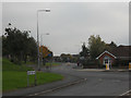
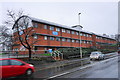
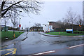
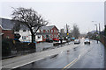
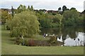

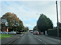
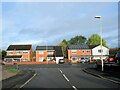

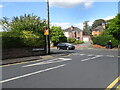
46 photos from this area
Area Information
Key information about the DY8 4JQ including its size, population, and administrative classification.
- Area Type
- Postcode
- Area Size
- 2.4 hectares
- Population
- 1462
- Population Density
- 4102 people/km²
House Prices in DY8 4JQ
71
Properties
£143,611
Average Sold Price
£32,000
Lowest Price
£290,000
Highest Price
Showing 71 properties
| Address | Type | Beds | Baths | Last Sale Price | Last Sale Date | |
|---|---|---|---|---|---|---|
| 37 Old Hall Close, Amblecote, DY8 4JQ | Bungalow | 2 | 1 | £210,000 | Aug 2025 | |
| 27 Old Hall Close, Amblecote, DY8 4JQ | Terraced | 1 | 1 | £152,000 | Jun 2025 | |
| 75 Old Hall Close, Amblecote, DY8 4JQ | Semi-detached | 2 | 1 | £213,000 | Jun 2024 | |
| 56 Old Hall Close, Amblecote, DY8 4JQ | Semi-detached | 2 | 1 | £195,000 | May 2024 | |
| 61 Old Hall Close, Amblecote, DY8 4JQ | Semi-detached | 2 | 1 | £218,000 | Mar 2024 | |
| 67 Old Hall Close, Amblecote, DY8 4JQ | house | 2 | 1 | £203,000 | Sep 2023 | |
| 66 Old Hall Close, Amblecote, DY8 4JQ | Semi-detached | 2 | 1 | £197,000 | Jul 2023 | |
| 59 Old Hall Close, Amblecote, DY8 4JQ | Semi-detached | 2 | 1 | £206,000 | May 2022 | |
| 23 Old Hall Close, Amblecote, DY8 4JQ | Terraced | 1 | - | £124,000 | Dec 2021 | |
| 24 Old Hall Close, Amblecote, DY8 4JQ | Maisonette | - | - | £61,700 | Nov 2021 |
Page 1 of 8
Energy Efficiency in DY8 4JQ
Amenities
Schools
| Rank | School | Type | Entry gender | Ages |
|---|
Explore more schools in this area
Go to Schools tabDemographics
Household Size
Two person
most common
Accommodation Type
Houses
most common
Tenure
79
majority
Ethnic Group
White
most common
Religion
N/A
most common
Household Composition
N/A
most common
Age
47
median
Adults (30-64 years)
most common
Household Deprivation
N/A
with no deprivation
NS-SEC
41
in Lower managerial occupations
Explore more demographic insights in this area
Go to Demographics tabPlanning
Planning Constraints
- Flood RiskPremium
- Ramsar Wetland SitesPremium
- Area of Outstanding Natural BeautyPremium
- Protected Nature ReservePremium
- Protected WoodlandPremium