Area Overview for CV3 6SD
Photos of CV3 6SD


Area Information
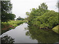
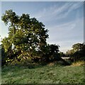
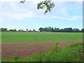
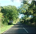
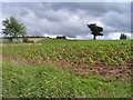
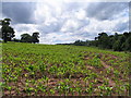
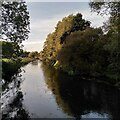
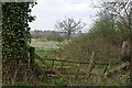
CV3 6SD is a small, tightly knit residential postcode in Warwickshire, encompassing a cluster of homes near the confluence of the River Sowe and River Avon. With a population of 4,079 spread over 3.3 hectares, it balances rural tranquillity with proximity to urban centres. Situated just 4–5 miles from Coventry city centre, the area benefits from easy access to regional hubs while retaining the charm of a traditional English village. The postcode borders the historic village of Stoneleigh, known for its 12th-century church, medieval abbey ruins, and connections to the Leigh family, who held the estate from the 16th to 20th centuries. Daily life here is shaped by a young demographic, with 80% of residents owning their homes and 130 people per square kilometre creating a close-knit community. The area’s character is defined by its historic architecture, including timber-framed cottages and sandstone almshouses, alongside modern amenities like supermarkets and rail links. For those seeking a blend of heritage and convenience, CV3 6SD offers a distinct lifestyle.
- Area Type
- Postcode
- Area Size
- 3.3 hectares
- Population
- 4079
- Population Density
- 130 people/km²
The property market in CV3 6SD is characterised by high home ownership (80%) and a predominance of houses over flats, reflecting a residential area suited to families and individuals seeking traditional housing. Given the postcode’s small size and limited land area, the housing stock is likely to be tightly concentrated, with properties ranging from modest homes to larger family houses. The high proportion of owner-occupied homes suggests a stable market with long-term residents, potentially limiting availability for renters. Buyers should consider the area’s proximity to Coventry and Stoneleigh’s historic sites, which may enhance property value. However, the small size of the postcode means competition for available homes could be fierce, particularly for those seeking specific features like gardens or historic character. The market is likely to cater more to first-time buyers and those prioritising location over expansive property sizes.
House Prices in CV3 6SD
Showing 1 properties
| Address | Type | Beds | Baths | Last Sale Price | Last Sale Date | |
|---|---|---|---|---|---|---|
| Severn Trent Water Ltd, Sherbourne House, Sewage Works, St Martins Road, Stoneleigh, CV3 6SD | Industrial | - | - | - | - |
Energy Efficiency in CV3 6SD
Living in CV3 6SD offers a mix of convenience and charm, with essential amenities within practical reach. Retail options include Morrisons Daily Coventry, Asda Coventry, and M&S Stonebridge Coventry BP, ensuring grocery and shopping needs are met without long journeys. The area’s proximity to Coventry and Stoneleigh also grants access to historic sites like Stoneleigh Abbey, the Norman Church of St Mary the Virgin, and the River Avon’s scenic paths. Rail links to Kenilworth, Canley, and Tile Hill stations provide easy access to cultural, educational, and employment opportunities in nearby towns. While the data does not specify parks or leisure facilities, the area’s historic character and nearby natural features suggest opportunities for outdoor activities. The blend of retail, transport, and heritage makes daily life here both practical and enriched by local history.
Amenities
Schools
| Rank | School | Type | Entry gender | Ages |
|---|
Explore more schools in this area
Go to Schools tabDemographics
The population of CV3 6SD is overwhelmingly young, with a median age of 22 and 15–29-year-olds making up the majority. This suggests a community skewed towards students, graduates, and young professionals, likely drawn by proximity to Coventry’s higher education institutions. Home ownership is high at 80%, indicating a stable, long-term resident base, with 80% of properties being houses rather than flats. The predominant ethnic group is White, reflecting the area’s traditional demographic profile. With a population density of 130 people per square kilometre, the area is neither overcrowded nor isolated, allowing for a balance between community interaction and personal space. The absence of specific data on deprivation or diversity means the area’s social fabric is largely defined by its youthful, owner-occupied population, which may influence local services and amenities tailored to this demographic.
Household Size
Accommodation Type
Tenure
Ethnic Group
Religion
Household Composition
Age
Household Deprivation
NS-SEC
Explore more demographic insights in this area
Go to Demographics tabPlanning
Planning Constraints
- Flood RiskPremium
- Ramsar Wetland SitesPremium
- Area of Outstanding Natural BeautyPremium
- Protected Nature ReservePremium
- Protected WoodlandPremium