Area Overview for CV23 9LB
Photos of CV23 9LB
Area Information
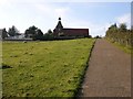
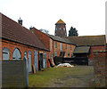
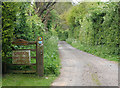
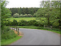
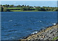
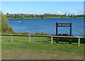
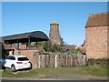
Living in CV23 9LB, located in Thurlaston, offers a distinctly rural experience close to Rugby. This specific postcode covers a small residential cluster spreading across 3.1 hectares. The area supports 1,455 residents in a setting defined by its proximity to natural landmarks. It lies approximately 1 mile west of Dunchurch and sits about 3.5 miles south-west of the main town of Rugby. The location provides views over Draycote Water reservoir to the south while remaining within the CV23 district of Warwickshire. Daily life here revolves around a quiet village atmosphere with easy motorway access. Thurlaston is immediately north of the M45 motorway, reached via a single dead-end road connecting to the B4429. This layout ensures minimal through-traffic while maintaining practical links to larger centres. The broader area is characterised by low population density and scenic countryside landscapes. You will find yourself near the Northamptonshire border in a community that prioritises space and peace. The village is home to Grade II listed St. Edmund's Church, a red brick building from 1849 designed by William Butterfield. This landmark anchors the local identity alongside other historic features. The largest Grade II listed building is an 18th-century windmill, now converted into a private house. These listed structures contribute to the area's preserved character. The civil parish status adds a layer of local government distinct from the surrounding urban sprawl. Prospective buyers looking for a tranquil environment with scenic views will recognise the appeal of this specific postcode. The combination of historic architecture, reservoir views, and motorway access creates a balanced settlement. You find a slice of rural England without being completely isolated from modern transport links.
- Area Type
- Postcode
- Area Size
- 3.1 hectares
- Population
- 1455
- Population Density
- 104 people/km²
The property market in CV23 9LB is defined by a stable, owner-occupied housing landscape. Homes in this postcode are predominantly houses, reflecting the village setting. Specifically, 93% of the residential units are owner-occupied. This figure is exceptionally high and signals a market where long-term residents form the majority. You will find very few purpose-built rental developments or new-build security flats in this specific area. The accommodation type is singularly focused on traditional housing stock. This high level of ownership suggests that Thurlaston residents plan to stay in their current properties for extended periods. The market is not driven by short-term tenancy turnover. Instead, value is often tied to specific plots of land and the quality of existing homes. The small area size of 3.1 hectares limits the scale of large-scale housing development. Future availability of new homes in this exact postcode may be constrained by planning complexities. The predominant ethnic group being White also aligns with traditional English rural property markets. Buyers looking for freehold properties with gardens will find a friendly environment. The housing stock consists mostly of detached or semi-detached houses rather than apartments. This configuration matches the needs of families and retirees seeking independent living spaces. The 93% ownership rate means you can interact directly with your future neighbours for recommendations. There is no significant student accommodation market here. The property type remains consistent with the broader CV23 area character.
House Prices in CV23 9LB
Showing 7 properties
| Address | Type | Beds | Baths | Last Sale Price | Last Sale Date | |
|---|---|---|---|---|---|---|
| Coven Hey, Grays Orchard, Thurlaston, CV23 9LB | Detached | 5 | 3 | £692,000 | May 2025 | |
| 1 Grays Orchard, Thurlaston, CV23 9LB | house | - | - | £390,000 | Nov 2012 | |
| 4 Grays Orchard, Thurlaston, CV23 9LB | Detached | - | - | £160,000 | Nov 2003 | |
| Ty Gwynt, Grays Orchard, Thurlaston, CV23 9LB | Detached | 5 | 3 | £225,000 | Jul 1997 | |
| 7 Grays Orchard, Thurlaston, CV23 9LB | Detached | - | - | £187,000 | Apr 1995 | |
| Glencree, 5 Grays Orchard, Thurlaston, CV23 9LB | Detached | - | - | - | - | |
| Orchard House, Grays Orchard, Thurlaston, CV23 9LB | house | - | - | - | - |
Energy Efficiency in CV23 9LB
Daily lifestyle for residents of CV23 9LB revolves around a small set of local amenities within practical reach. You can rely on five retail outlets for everyday shopping needs. Notable venues include the Co-op Rugby, Tesco Rugby, and the Heart of England Co-operative Co. These shops are located in the nearby Rugby centre rather than directly on the village high street. This arrangement means you have access to a complete range of goods and fresh food. The rail connection to Rugby station complements this retail availability by offering easy public transport access to shopping districts. Beyond shopping, the village offers a deep connection to the natural landscape. The southern border overlooks the vast Draycote Water reservoir. This body of water provides opportunities for walking, fishing, and picnicking directly from your property. The location near the Northamptonshire border enhances the rural character of the area. Residents enjoy a lifestyle defined by open spaces rather than dense urban environments. The presence of the M45 motorway allows for quick trips into the city if desired, yet the village itself remains quiet and peaceful. Cultural life centres around historic landmarks like the Grade II listed St. Edmund's Church. This red brick building from 1849, designed by William Butterfield, serves as a focal point. The nearby 18th-century windmill, also a Grade II listed building, adds to the architectural heritage. You can stroll past these structures while enjoying the scenic countryside views. The community spirit is strengthened by proximity to shared histories and natural beauty. The presence of these specific named venues ensures a culturally rich yet low-maintenance lifestyle.
Amenities
Schools
Families considering living in CV23 9LB will find two primary schools nearby. The closest option is Dunchurch Infant School, which functions as a primary institution. The second nearby facility is Dunchurch Boughton Church of England Infant Academy and Nursery. This location operates as an academy providing early education for young children. Both establishments serve infants, catering to pupils in the earlier stages of their schooling. There are no secondary schools or higher education institutions listed within the immediate vicinity of this postcode. The presence of two infant academies indicates a focus on foundational education for young residents. You will find that schools near CV23 9LB are situated just outside the village limits but within commuting distance. The mix of school types is limited to primary and infant level early years provision. This setup works well for young children living in the Thurlaston village. The proximity of these specific named schools offers convenience for parents with infants and junior children. However, residents with older children seeking secondary education options must look further afield beyond this immediate cluster. The local education landscape is intimate, centred on the academic needs of the youngest pupils. The Church of England affiliation of one academy adds a specific faith-based dimension to the choice of education. Dunchurch Infant School serves the general community religiously or secularly depending on its specific admissions policy. The academy structure of the second school brings modern accountability to the local provision.
| Rank | School | Type | Entry gender | Ages |
|---|
Explore more schools in this area
Go to Schools tabDemographics
The community profile within CV23 9LB reveals a mature population with a median age of 47 years. The most common age group consists of elderly residents over 65 years old. This demographic trend shapes the vibrancy and pace of life in Thurlaston. You will encounter an community where many families may have moved away or retired to this postcard-perfect location. The area accommodates 93% owner-occupied homes. This exceptionally high home ownership statistic indicates long-term stability within the neighbourhood. Most residents live in traditional houses rather than flats or high-density accommodation. Specific data categorises the predominant accommodation type clearly as houses. This aligns with the rural village character of Thurlaston and the surrounding CV23 district. The population density stands at 104 people per square kilometre, reflecting a spacious living environment. The predominant ethnic group in the area is White, consistent with many older English rural villages. This demographic homogeneity contributes to a uniform community feel. Nine out of ten households own their properties outright or with a mortgage. This contrasts sharply with rental-heavy urban centres where tenants often change frequently. The stability allows for stronger local networks and community engagement. The low density of 104 people per square kilometre means you have generous space outdoors. The population figures show 1,455 residents in this specific postcode. The age skew towards older adults suggests a slower lifestyle focused on relaxation. You are living in a place where the primary residents have likely built their lives locally over decades.
Household Size
Accommodation Type
Tenure
Ethnic Group
Religion
Household Composition
Age
Household Deprivation
NS-SEC
Explore more demographic insights in this area
Go to Demographics tabPlanning
Planning Constraints
- Flood RiskPremium
- Ramsar Wetland SitesPremium
- Area of Outstanding Natural BeautyPremium
- Protected Nature ReservePremium
- Protected WoodlandPremium