Area Overview for CV2 4HJ
Photos of CV2 4HJ

Area Information
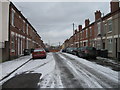
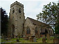
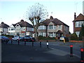
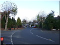
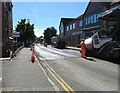
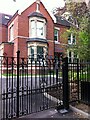
CV2 4HJ is a small, densely populated residential postcode in Coventry, England, covering 176 m² and home to 2,031 residents. This area, part of the Wyken and Upper Stoke Character Area, blends historic charm with suburban practicality. Its roots trace back to medieval Stoke, where open fields were enclosed in the 17th century, later evolving into terraced and semi-detached housing. Today, the area features small homes with rear gardens, set back from roads, reflecting its long-standing suburban character. With a median age of 22, yet a majority of residents aged 30–64, the community balances younger and middle-aged demographics. Proximity to Coventry’s rail network, including Canley and Bedworth stations, and retail hubs like Tesco Ball Hill and Iceland Binley, ensures daily convenience. The area’s compact size and rich historical backdrop—marked by sites like the 14th-century Church of St Michael—offer a distinct blend of heritage and modern living, appealing to those seeking a connected yet rooted lifestyle.
- Area Type
- Postcode
- Area Size
- 176 m²
- Population
- 2031
- Population Density
- 8955 people/km²
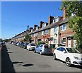
The property market in CV2 4HJ is characterised by a low home ownership rate of 20%, suggesting that most residents are renters rather than homeowners. The area’s accommodation is predominantly houses—specifically small terraced and semi-detached properties—many of which feature rear gardens and front gardens adapted for parking. This housing stock reflects a suburban layout, with homes set back from roads, typical of the area’s 17th-century origins. Given the small size of the postcode and the focus on houses, the market is limited in scale, offering fewer options for buyers compared to larger urban areas. For those seeking property, the emphasis on rental dwellings may mean competition for available homes, particularly for owner-occupiers. The compact nature of the area also means that immediate surroundings are critical for buyers to consider, as housing choices are constrained by the postcode’s boundaries.
House Prices in CV2 4HJ
No properties found in this postcode.
Energy Efficiency in CV2 4HJ
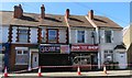
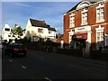
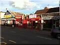
Living in CV2 4HJ offers access to a range of amenities within practical reach, enhancing daily life. Retail options include Heron Upper, Tesco Ball Hill, and Iceland Binley, providing essential shopping and convenience. The area’s rail connections—such as Coventry Arena, Canley, and Bedworth stations—facilitate easy travel to work, leisure, or social activities. Nearby airports, including Coventry Airport, add to the area’s accessibility. The suburban character of CV2 4HJ, with its small terraced houses and rear gardens, complements a lifestyle that balances proximity to services with a sense of community. While the area lacks large parks or recreational spaces, its historical sites—like the Grade II* listed Church of St Michael—offer cultural and architectural interest. The combination of retail, transport, and historic charm creates a practical yet distinctive environment for residents.
Amenities
Schools
| Rank | School | Type | Entry gender | Ages |
|---|
Explore more schools in this area
Go to Schools tabDemographics
The population of CV2 4HJ is 2,031, with a median age of 22, though the most common age group is adults aged 30–64. This suggests a mix of younger residents and families. Home ownership is low at 20%, indicating a predominantly rental market, with accommodation types focused on houses—primarily small terraced and semi-detached properties. The predominant ethnic group is White, reflecting the area’s demographic profile. The high population density of 11,548,316 people per km² underscores a compact, closely knit community. While this density may contribute to a lively, interconnected environment, it also means limited space for expansion. For residents, this translates to a tight-knit neighbourhood where services and amenities are within close reach, though the high proportion of renters may influence local dynamics, such as transient populations or shared housing.
Household Size
Accommodation Type
Tenure
Ethnic Group
Religion
Household Composition
Age
Household Deprivation
NS-SEC
Explore more demographic insights in this area
Go to Demographics tabPlanning
Planning Constraints
- Flood RiskPremium
- Ramsar Wetland SitesPremium
- Area of Outstanding Natural BeautyPremium
- Protected Nature ReservePremium
- Protected WoodlandPremium