Area Overview for CV2 4RF
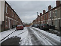
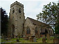
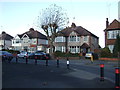
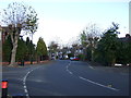
Photos of CV2 4RF


Area Information
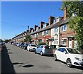
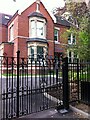
CV2 4RF lies within the Wyken and Upper Stoke Character Area of Coventry, a historic settlement rooted in medieval open fields and 17th-century enclosures. With a population of 2,031, it is a small, tightly knit residential cluster defined by its suburban layout of terraced and semi-detached houses, many with rear gardens and road setbacks. The area’s character is shaped by its past as a site of medieval manors, such as the 14th-century Church of St Michael and the moated Biggin Hall, now integrated into modern living. Daily life here balances proximity to Coventry’s urban amenities with a quieter, more residential atmosphere. The postcode is served by five rail stations, including Coventry Arena and Bedworth, offering easy access to the city’s cultural and economic hubs. Despite its compact size, the area retains historical layers, from 19th-century brickworks to inter-war housing developments for munitions workers. Its blend of heritage and practicality makes it a distinct choice for those seeking a manageable, connected community with a foothold in Coventry’s evolving landscape.
- Area Type
- Postcode
- Area Size
- Not available
- Population
- 2031
- Population Density
- 8955 people/km²
The property market in CV2 4RF is characterised by a low home ownership rate of 20%, indicating that the area is primarily a rental market rather than one dominated by owner-occupied homes. The accommodation type is predominantly houses, specifically small terraced and semi-detached properties, which are typical of the suburban layout described in the area’s historical development. This housing stock, with its emphasis on rear gardens and setbacks from roads, suggests a focus on practical, family-friendly living. However, the limited home ownership percentage implies that buyers may face competition from renters, particularly in a small area with constrained housing availability. For those considering purchase, the market’s rental orientation means properties are likely to be targeted at tenants rather than long-term investors. The compact size of the postcode also means that the immediate surrounding areas may hold more significant opportunities for buyers seeking larger or varied property options.
House Prices in CV2 4RF
No properties found in this postcode.
Energy Efficiency in CV2 4RF
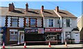
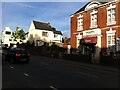
Residents of CV2 4RF have access to a range of local amenities within practical reach. Retail options include Heron Upper, Tesco Ball Hill, and Iceland Binley, offering everyday shopping needs. The area’s rail network, with stations such as Coventry Arena and Bedworth, provides convenient links to Coventry’s cultural and commercial centres, while the presence of two airports—Coventry Airport—enhances travel flexibility. Though specific details on dining or leisure facilities are not provided, the proximity to historical sites like the Grade II* listed Church of St Michael and the remnants of medieval Stoke suggest a blend of heritage and suburban convenience. The layout of small terraced houses with rear gardens supports a lifestyle that balances community living with private outdoor space. The availability of rail services and retail hubs ensures that daily life in CV2 4RF is both functional and connected to broader regional opportunities.
Amenities
Schools
| Rank | School | Type | Entry gender | Ages |
|---|
Explore more schools in this area
Go to Schools tabDemographics
The population of CV2 4RF is 2,031, with a median age of 22, though the most common age range is adults aged 30–64. This suggests a mix of younger residents and a mature demographic, possibly reflecting student populations or workers in nearby industries. Home ownership here is low, at 20%, indicating that the majority of residents are likely to be renters. The area is predominantly occupied by houses, specifically small terraced and semi-detached properties, which align with the suburban housing stock described in historical records. The predominant ethnic group is White, though specific data on diversity is not provided. The low home ownership rate may influence the community’s transient nature, while the age profile hints at a balance between established families and younger professionals. The absence of detailed deprivation data means the quality of life implications of these figures remain contextual, but the demographic structure suggests a community shaped by both local employment opportunities and proximity to Coventry’s broader economy.
Household Size
Accommodation Type
Tenure
Ethnic Group
Religion
Household Composition
Age
Household Deprivation
NS-SEC
Explore more demographic insights in this area
Go to Demographics tabPlanning
Planning Constraints
- Flood RiskPremium
- Ramsar Wetland SitesPremium
- Area of Outstanding Natural BeautyPremium
- Protected Nature ReservePremium
- Protected WoodlandPremium