Area Overview for CV2 2TS
Photos of CV2 2TS


Area Information
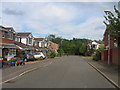
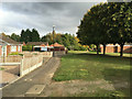
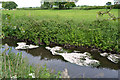
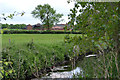
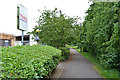
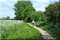
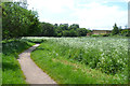
CV2 2TS is a small, densely populated residential area in Coventry, England, encompassing 4.7 hectares and home to 1,472 residents. Its compact size and high population density of 31,135 people per square kilometre reflect a tightly knit community. Nestled between Stoke and Walsgrave, it is part of the Wyken ward, historically a village that evolved into a suburban enclave. The area features mostly terraced houses, with a strong sense of local identity rooted in its medieval past. St Mary Magdalene’s Church, dating to the 11th century, and Wyken Slough, a body of water formed by 19th-century colliery subsidence, add character. Daily life here balances suburban tranquillity with proximity to Coventry’s city centre, offering residents access to retail, transport, and cultural amenities. The area’s mix of historic charm and modern infrastructure makes it appealing to those seeking a stable, community-focused lifestyle.
- Area Type
- Postcode
- Area Size
- 4.7 hectares
- Population
- Not available
- Population Density
- Not available
CV2 2TS is predominantly an owner-occupied area, with 80% of homes owned by residents rather than rented. The accommodation type is primarily houses, which is unusual for a small postcode area but reflects the suburban character of Wyken. This suggests a market skewed towards family homes rather than apartments or flats. The limited size of the area means housing stock is constrained, and buyers may need to consider nearby zones for more options. The high home ownership rate indicates a stable community with long-term residency, which can be a plus for those seeking a settled environment. However, the small footprint of CV2 2TS itself means property availability is limited, requiring careful consideration of proximity to amenities and transport links.
House Prices in CV2 2TS
Showing 1 properties
| Address | Type | Beds | Baths | Last Sale Price | Last Sale Date | |
|---|---|---|---|---|---|---|
| Pharmacy, Tesco Supermarket, Clifford Bridge Road, Coventry, CV2 2TS | shop | - | - | - | - |
Energy Efficiency in CV2 2TS
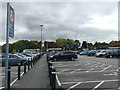
CV2 2TS offers a range of amenities within practical reach, including five retail outlets such as Tesco Coventry, M&S University Hospital Coventry SF, and Asda Living. Three rail stations provide easy access to Coventry and surrounding areas, while two airports cater to travel needs. The area’s suburban character is complemented by historical landmarks like St Mary Magdalene’s Church and Wyken Slough, offering recreational and cultural value. The mix of retail, transport, and natural features supports a convenient lifestyle, blending modern convenience with local heritage. Residents can enjoy a balance of daily necessities and leisure opportunities, though the small area size means some amenities may require a short trip to nearby zones.
Amenities
Schools
The nearest school to CV2 2TS is Coventry Alternative Provision Academy, categorised as an ‘other’ school. No Ofsted rating is provided in the data, so prospective families should verify its performance independently. The single listed school suggests a limited range of educational options, which may be a consideration for families with specific needs. The absence of primary or secondary schools in the immediate vicinity could require residents to travel to nearby areas for broader schooling choices. For those prioritising a variety of educational institutions, the area’s school landscape may necessitate a closer look at commuting distances and alternative provision.
| Rank | School | Type | Entry gender | Ages |
|---|
Explore more schools in this area
Go to Schools tabDemographics
The population of CV2 2TS is predominantly adults aged 30–64, with a median age of 47. Eighty per cent of residents own their homes, and the accommodation type is largely houses, reflecting a stable, family-oriented demographic. The predominant ethnic group is White, though no specific diversity statistics are provided. The high population density of 31,135 people per square kilometre suggests a compact, closely packed community. This density may influence local services and social dynamics, creating a mix of long-term residents and newer arrivals. The age profile indicates a mature population, which could impact local amenities and school needs. For buyers, this profile suggests a neighbourhood with established infrastructure but limited scope for rapid growth or change.
Household Size
Accommodation Type
Tenure
Ethnic Group
Religion
Household Composition
Age
Household Deprivation
NS-SEC
Explore more demographic insights in this area
Go to Demographics tabPlanning
Planning Constraints
- Flood RiskPremium
- Ramsar Wetland SitesPremium
- Area of Outstanding Natural BeautyPremium
- Protected Nature ReservePremium
- Protected WoodlandPremium