Area Overview for B93 0NJ
Photos of B93 0NJ


Area Information
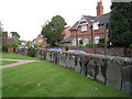
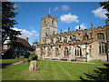
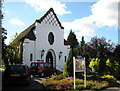
Living in B93 0NJ offers a distinct experience within the larger settlement of Knowle in the Metropolitan Borough of Solihull. This specific postcode covers a small residential cluster defined by an area size of 1,635 square metres. It holds a population of 1,635 people, creating a tight-knit community situated approximately three miles east-southeast of Solihull town centre. Historically, this location lies within the historic Arden area of Warwickshire, positioned midway between Birmingham and Warwick on the A4141. While Knowle grew from a small agricultural settlement into a larger residential community with a ward population of around 11,000, the character of B93 0NJ remains rooted in its village origins. The area retains historic charm alongside modern residential development, with the Conservation Area focusing on the High Street and a 15th-century church. Residents enjoy the benefits of being mid-way between major cities while living in an environment defined by its retention of historic character. Daily life here balances the quietude of a village with the practicalities of a suburban hub. The settlement is well-connected via the A4141 road and features excellent digital infrastructure. For those considering homes in this specific cluster, the combination of historical significance, manageable population density, and modern amenities creates a defined lifestyle.
- Area Type
- Postcode
- Area Size
- 1504 m²
- Population
- 1635
- Population Density
- 865 people/km²
The property market in B93 0NJ is dominated by owner-occupied housing stock. Data confirms that 61 per cent of households own their homes, creating a bubble of stability for both current residents and potential buyers. The predominant accommodation type is houses, which aligns with the median age of 47 and the high homeownership rate. This structure contrasts with areas where rental blocks or student accommodation drive the market. You are looking at a residential cluster where properties are typically family homes designed for long-term living rather than short-term tenancy agreements. The specific area size of 1,635 square metres suggests a compact, perhaps detached or semi-detached, housing footprint typical of Knowle's expansion patterns. Because the area is a small residential cluster within a larger ward population of approximately 11,000, inventory may move slower than in high-density urban centres. The market is defined by substance rather than speculation. Buyers seeking a home in this postcode will find an environment focused on ownership. The lack of rental properties in the data suggests a market where assets are held for generational wealth or stable family life. This reality simplifies the search process, removing the complexity of managing tenancies from the equation.
House Prices in B93 0NJ
No properties found in this postcode.
Energy Efficiency in B93 0NJ
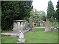
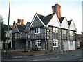
Daily life in B93 0NJ is enriched by a range of amenities gathered within a short practical distance. For retail needs, you have five local options, including Tesco Knowle, Asda Widney, and Co-op Bentley. These venues provide essentials without requiring a lengthy journey into town. Rail connectivity extends your lifestyle significantly, with five stations nearby like Dorridge and Widney Manor offering regular train services. For those requiring air travel or national rail connections, two major stations are accessible, notably Birmingham International Railway Station and Birmingham International Airport. The area preserves a strong sense of history through its landmarks. The Grand Union Canal features a flight of five locks, offering a thriving boatyard and moorings. Two pubs exist within walking distance of this leisure facility, providing a traditional social hub. The High Street and Guild House anchor the Conservation Area, where numerous 16th and 17th-century timber-framed buildings remain. Specific venues like the Berrow Homes and Victorian terraced cottages shape the streetscape. This mix of historic landmarks and modern retail creates a balanced environment. You can enjoy a stroll along the canal or visit a historic pub before shopping at a nearby supermarket. This blend ensures you have everything you need nearby while maintaining access to wider regional services.
Amenities
Schools
| Rank | School | Type | Entry gender | Ages |
|---|
Explore more schools in this area
Go to Schools tabDemographics
The community in B93 0NJ reflects a mature demographic profile suited for stability and established living. The median age stands at 47 years, with adults in the 30 to 64 years age range being the most common residents. This age distribution suggests an area where families and professionals have put down roots rather than a transient market of students or young commuters. Home ownership is a defining feature of this neighbourhood, with 61 per cent of residents owning their homes outright or with a mortgage. This high ownership rate contrasts sharply with rental-heavy districts and indicates long-term settlement patterns. The accommodation consists entirely of houses, offering private gardens and living spaces typical of suburban family life. The predominant ethnic group is White, reflecting a traditional neighbourhood structure common in the West Midlands. There is no data on deprivation levels provided for this specific cluster, but the high rate of home ownership and the age profile suggest a financially stable community without obvious signs of acute hardship. The demographic makeup supports a calm environment where services are likely tailored to the needs of adults and children, making it a reliable choice for those prioritising established neighbourhood values.
Household Size
Accommodation Type
Tenure
Ethnic Group
Religion
Household Composition
Age
Household Deprivation
NS-SEC
Explore more demographic insights in this area
Go to Demographics tabPlanning
Planning Constraints
- Flood RiskPremium
- Ramsar Wetland SitesPremium
- Area of Outstanding Natural BeautyPremium
- Protected Nature ReservePremium
- Protected WoodlandPremium