Area Overview for B93 3JE
Photos of B93 3JE


Area Information
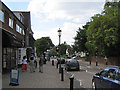
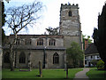
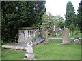
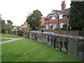
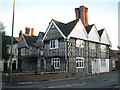
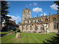
Living in B93 3JE means inhabiting a small residential cluster in the heart of Knowle, a village in Solihull’s Metropolitan Borough. With a population of 1,635 and a density of 865 people per square kilometre, this area balances compact living with a village atmosphere. Knowle’s history as an agricultural settlement has given way to a modern residential community, yet its charm persists. The High Street, a conservation area, retains 15th-century architecture and historic timber-framed buildings, while the Grand Union Canal, with its flight of five locks, offers leisure opportunities. Situated midway between Birmingham and Warwick on the A4141, B93 3JE benefits from proximity to both cities without the congestion of urban centres. Daily life here blends practicality with heritage: residents can access rail links to Solihull, Birmingham, and the airport, while the village’s character remains intact. This postcode is ideal for those seeking a quieter lifestyle with easy access to transport, retail, and cultural amenities, all within a tight-knit community.
- Area Type
- Postcode
- Area Size
- Not available
- Population
- 1635
- Population Density
- 865 people/km²
The property market in B93 3JE is defined by a high rate of home ownership (61%) and a predominance of houses. This suggests a community where long-term residency is common, with properties likely to be family homes rather than rental units. The focus on houses, rather than flats or apartments, aligns with the area’s suburban character and conservation efforts. Given the small size of the postcode, the housing stock is limited, but the mix of historic and modern properties offers variety. Buyers should consider that the area’s appeal lies in its blend of heritage and practicality, with homes likely to be well-maintained and situated in a low-density, village-like setting. The proximity to rail links and major roads may also enhance property value, though the small size of the postcode means competition for available homes could be intense.
House Prices in B93 3JE
No properties found in this postcode.
Energy Efficiency in B93 3JE
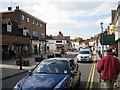
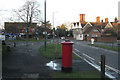
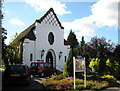
Residents of B93 3JE have access to a range of amenities within practical reach. The High Street hosts shops like Tesco Knowle, Asda Widney, and Co-op Bentley, ensuring daily essentials are easily accessible. Rail stations such as Dorridge and Solihull provide connections to Birmingham’s business districts and beyond, while Birmingham International Airport is a short trip away. The Grand Union Canal, with its historic locks and boatyard, offers leisure opportunities, complemented by nearby pubs and the village’s conservation area. The area’s character is defined by its mix of historic timber-framed buildings and modern housing, creating a unique atmosphere. For families, the proximity to schools and the village’s quiet streets provide a balanced lifestyle. The blend of retail, transport, and natural features makes daily life in B93 3JE both convenient and enjoyable.
Amenities
Schools
| Rank | School | Type | Entry gender | Ages |
|---|
Explore more schools in this area
Go to Schools tabDemographics
The community in B93 3JE skews towards middle-aged residents, with a median age of 47 and the majority of residents falling within the 30-64 age range. Home ownership is strong, with 61% of properties occupied by their owners, suggesting a stable, long-term demographic. The area is predominantly composed of houses, reflecting a focus on family-oriented living. The predominant ethnic group is White, though no specific data on diversity or minority representation is provided. The age profile indicates a mature population, which may influence local services and amenities. With no mention of deprivation levels, the area appears to support a quality of life aligned with its historic and residential character. The absence of younger or older demographics might suggest a community prioritising stability over rapid change.
Household Size
Accommodation Type
Tenure
Ethnic Group
Religion
Household Composition
Age
Household Deprivation
NS-SEC
Explore more demographic insights in this area
Go to Demographics tabPlanning
Planning Constraints
- Flood RiskPremium
- Ramsar Wetland SitesPremium
- Area of Outstanding Natural BeautyPremium
- Protected Nature ReservePremium
- Protected WoodlandPremium
- Crime RiskPremium