Area Overview for B80 7LY
Photos of B80 7LY
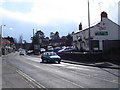
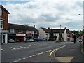
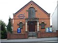
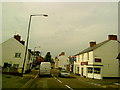
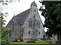
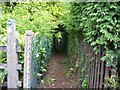
55 photos from this area
Area Information
Key information about the B80 7LY including its size, population, and administrative classification.
- Area Type
- Postcode
- Area Size
- 2.1 hectares
- Population
- 1655
- Population Density
- 249 people/km²
House Prices in B80 7LY
40
Properties
£198,902
Average Sold Price
£58,000
Lowest Price
£418,000
Highest Price
Showing 40 properties
| Address | Type | Beds | Baths | Last Sale Price | Last Sale Date | |
|---|---|---|---|---|---|---|
| The Greswold, New Road, Studley, B80 7LY | Detached | 3 | 2 | £418,000 | Nov 2024 | |
| Marl View, New Road, Studley, B80 7LY | Semi-detached | 3 | 1 | £316,000 | Jun 2024 | |
| 18 New Road, Studley, B80 7LY | Semi-detached | 3 | 1 | £315,000 | Mar 2024 | |
| 38 New Road, Studley, B80 7LY | Semi-detached | 3 | 1 | £200,000 | Dec 2023 | |
| 37 New Road, Studley, B80 7LY | Semi-detached | 2 | 1 | £266,000 | Jul 2023 | |
| 17 New Road, Studley, B80 7LY | house | 3 | 1 | £235,000 | Mar 2022 | |
| 34 New Road, Studley, B80 7LY | Terraced | 3 | - | £245,000 | Nov 2021 | |
| 33 New Road, Studley, B80 7LY | house | 3 | 1 | £205,000 | Nov 2021 | |
| 3A, Eagle Buildings, New Road, Studley, B80 7LY | Flat | 2 | 1 | £127,500 | Jun 2021 | |
| Apple Tree Cottage, New Road, Studley, B80 7LY | Semi-detached | 4 | 2 | £285,000 | Aug 2017 |
Page 1 of 4
Energy Efficiency in B80 7LY
Amenities
Schools
| Rank | School | Type | Entry gender | Ages |
|---|
Explore more schools in this area
Go to Schools tabDemographics
Household Size
Two person
most common
Accommodation Type
Houses
most common
Tenure
75
majority
Ethnic Group
White
most common
Religion
N/A
most common
Household Composition
N/A
most common
Age
47
median
Adults (30-64 years)
most common
Household Deprivation
N/A
with no deprivation
NS-SEC
38
in Lower managerial occupations
Explore more demographic insights in this area
Go to Demographics tabPlanning
Planning Constraints
- Flood RiskPremium
- Ramsar Wetland SitesPremium
- Area of Outstanding Natural BeautyPremium
- Protected Nature ReservePremium
- Protected WoodlandPremium