Area Overview for B69 3DL
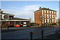
Photos of B69 3DL


Area Information
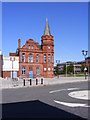
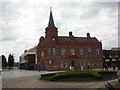
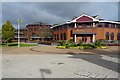
Living in B69 3DL offers a settled residential experience within a specific postcode area covering a small residential cluster of 2.7 hectares. You will find 2441 residents populating this dense locality, which sits in Oldbury, part of the Sandwell metropolitan borough. The area developed historically from its roots as part of the Manor of Halesowen, evolving through industrial eras involving ironworks and coal mining before merging into the modern borough in 1974. Today, the neighbourhood retains a distinct character defined by its proximity to the town centre and its historical landmarks such as Christchurch, which opened in 1841. Experienced residents often appreciate the blend of old customs with modern infrastructure, including the Albright Recreation Ground, which has hosted sports pitches since 1886. The postcode itself marks a small but significant residential knot where history meets contemporary living. You are situated near key transport links like the Sandwell & Dudley Railway Station and enjoy access to main retail locations such as Sainsburys Oldbury. This specific postcode area functions as a practical base for families who value proximity to employment hubs in the broader West Midlands.
- Area Type
- Postcode
- Area Size
- 2.7 hectares
- Population
- 2441
- Population Density
- 1643 people/km²
The property market in B69 3DL is characterised by strong ownership levels and a focus on residential housing. Houses dominate the accommodation landscape, aligning with the preference of the majority of residents who have purchased their properties. With 56% of households owning their homes, this postcode operates more as an owner-occupied area than a high-density rental market. This high ownership rate often implies stable neighbourhoods where families remain for several years. Buyers looking at this small area or its immediate surroundings will find a stock primarily suited to domestic living rather than the transient nature of student or short-term rentals. The specific postcode B69 3DL covers 2.7 hectares, meaning properties here are likely well-situated within a defined cluster rather than spread thinly across the wider district. When considering homes in this location, you should expect a traditional mix typical of the West Midlands. The combination of high ownership and a house-focused stock points to an area where land values and property prices are driven by those seeking a permanent base. Prospective buyers may find that competition exists where the supply of houses matches the demand from the existing owner-occupying demographic.
House Prices in B69 3DL
No properties found in this postcode.
Energy Efficiency in B69 3DL
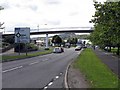
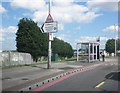
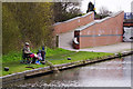
Daily life in B69 3DL offers convenient access to essential amenities within a short radius. You can reach Sainsburys Oldbury, Iceland Oldbury, and Spar supermarkets for shopping needs without requiring a long journey. Five retail venues operate close enough to support regular grocery shopping and household provisions. For public transport, five rail stations are accessible, including Sandwell & Dudley and Langley Green, facilitating easy travel plans. Additionally, five metro locations such as West Bromwich Central and Lodge Road provide further mobility options for commuting or leisure trips. The area includes historical landmarks like the Old Courthouse, now serving as a library, and the Christchurch opened in 1841. The Albright Recreation Ground offers sports pitches and an ornamental pool for local leisure activities. These facilities create a balanced environment where work, shopping, and recreation intersect. The presence of specific chains like Sainsburys and Iceland ensures familiarity while local institutions like the library maintain community character. Residents benefit from this mix of high-street reliability and local heritage.
Amenities
Schools
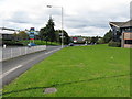
Families living in B69 3DL have access to a concentration of educational facilities near their homes. Rounds Green Primary School holds a 'good' Ofsted rating and serves as a key option for early education in the locality. You will also find Rounds Green Junior School and Rounds Green Infant School nearby, both offering primary-level instruction. The proximity of these three institutions provides multiple choices for parenting decisions within the immediate vicinity. Residents benefit from having specific schools listed in adjacent areas, ensuring that daily commutes for children are minimal. The mix of infant and primary options under the Rounds Green banner suggests a model where younger children transition smoothly within the same campus environment. While other educational institutions may exist further afield, these named schools represent the core educational provision for families in this postcode area. When researching schools near B69 3DL, you will find that the local education system offers a focused selection of primary education providers. This concentration allows parents to engage directly with headteachers and attend local performances or sports events at the Albright Recreation Ground, which serves as a hub for school activities.
| Rank | School | Type | Entry gender | Ages |
|---|
Explore more schools in this area
Go to Schools tabDemographics
The community in B69 3DL is defined by a mature population profile. A median age of 47 indicates that the neighbourhood predominantly hosts adults between 30 and 64 years old. Over half of the local households, representing 56% of residents, own their homes. The remaining 44% of the population comprises tenants or those moving through the property market. Houses constitute the primary accommodation type, reflecting a traditional housing stock suited to family life and established residents. The predominant ethnic group is White, though the area maintains a community structure focused on long-term local settlement. Regarding deprivation, the absence of specific deprivation scores in the available data suggests the area does not face acute disadvantage issues highlighted in broader reports. However, the high home ownership rate often correlates with stable community networks. The demographic split between owner-occupiers and renters reflects a typical English suburban pattern. With 1643 people per square kilometre, the density supports a lively local environment without the congestion found in urban centres. This profile suggests a neighbourhood where residents have established roots and contribute to local stability.
Household Size
Accommodation Type
Tenure
Ethnic Group
Religion
Household Composition
Age
Household Deprivation
NS-SEC
Explore more demographic insights in this area
Go to Demographics tabPlanning
Planning Constraints
- Flood RiskPremium
- Ramsar Wetland SitesPremium
- Area of Outstanding Natural BeautyPremium
- Protected Nature ReservePremium
- Protected WoodlandPremium