Area Overview for B63 3JA
Photos of B63 3JA
Area Information
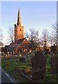
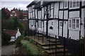
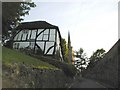
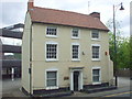
Living in B63 3JA means being part of a tightly knit residential cluster within the Dudley Metropolitan Borough. This small postcode area, covering 8,420 square metres, is home to 1,469 people, making it one of the most densely populated regions in England. Its history is deeply rooted in the broader Halesowen area, once an exclave of Shropshire before its integration into Worcestershire in 1844. Today, it sits within the Black Country’s urban fabric, blending suburban living with historical significance. The area is near landmarks like Halesowen Abbey ruins and the Leasowes public park, offering glimpses of medieval heritage alongside modern convenience. Daily life here is shaped by proximity to rail networks, retail hubs, and green spaces, creating a balance between accessibility and tranquillity. The community is predominantly composed of adults aged 30–64, with a median age of 47, reflecting a mature, stable demographic. For buyers, B63 3JA represents a compact, high-density environment with strong transport links and a distinct local character.
- Area Type
- Postcode
- Area Size
- 8420 m²
- Population
- 1469
- Population Density
- 5395 people/km²
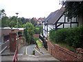
B63 3JA is a predominantly owner-occupied area, with 79% of homes owned by residents rather than rented. The accommodation type is largely houses, which is typical for suburban postcode clusters. This suggests a housing stock focused on family homes rather than apartments or flats. The small area size and high population density imply limited land for new developments, which could make the market competitive for buyers seeking properties in this specific postcode. However, the proximity to nearby towns like Halesowen and the presence of rail links may provide alternatives for those needing more space. For buyers, the high home ownership rate indicates a stable market with long-term residents, though the compact nature of the area means options are likely limited to existing stock.
House Prices in B63 3JA
No properties found in this postcode.
Energy Efficiency in B63 3JA
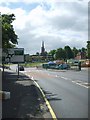
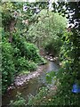
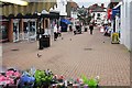
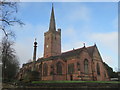
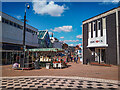
Residents of B63 3JA have access to a range of amenities within walking or short driving distance. Retail options include Iceland, Heron, and Lidl in Halesowen, offering everyday shopping needs. The area’s rail stations connect to nearby towns, while metro stops like West Bromwich Central provide links to larger cities. For leisure, the Leasowes public park — a 57-hectare space with 18th-century landscape features — is nearby, offering walking trails and open greenery. Historical sites such as the ruins of Halesowen Abbey and the Parish Church of St John the Baptist add cultural value. The mix of retail, transport, and green spaces creates a lifestyle that balances convenience with access to heritage and outdoor recreation.
Amenities
Schools
| Rank | School | Type | Entry gender | Ages |
|---|
Explore more schools in this area
Go to Schools tabDemographics
The population of B63 3JA is 1,469 people, with a population density of 174,460 per square kilometre — among the highest in the UK. The median age is 47, with the majority of residents aged 30–64, indicating a community of established professionals and families. Home ownership is high at 79%, suggesting a long-term presence of residents. The area is predominantly White, with no specific data on other ethnic groups provided. The accommodation type is primarily houses, reflecting a suburban layout rather than high-rise or flats. This demographic profile points to a mature, settled population with a focus on stability. The high home ownership rate and age range suggest a community with strong ties to local institutions, though the lack of detailed diversity data means broader social dynamics remain unclear.
Household Size
Accommodation Type
Tenure
Ethnic Group
Religion
Household Composition
Age
Household Deprivation
NS-SEC
Explore more demographic insights in this area
Go to Demographics tabPlanning
Planning Constraints
- Flood RiskPremium
- Ramsar Wetland SitesPremium
- Area of Outstanding Natural BeautyPremium
- Protected Nature ReservePremium
- Protected WoodlandPremium