Area Overview for B62 9NT
Photos of B62 9NT
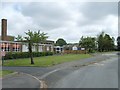
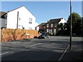
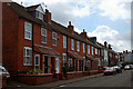

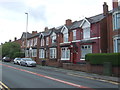


14 photos from this area
Area Information
Key information about the B62 9NT including its size, population, and administrative classification.
- Area Type
- Postcode
- Area Size
- 1.2 hectares
- Population
- 1373
- Population Density
- 3089 people/km²
House Prices in B62 9NT
18
Properties
£150,121
Average Sold Price
£61,000
Lowest Price
£285,000
Highest Price
Showing 18 properties
| Address | Type | Beds | Baths | Last Sale Price | Last Sale Date | |
|---|---|---|---|---|---|---|
| 138 Summerfields Avenue, Halesowen, B62 9NT | Semi-detached | 3 | 1 | £285,000 | Oct 2023 | |
| 141 Summerfields Avenue, Halesowen, B62 9NT | house | - | - | £210,000 | Jan 2020 | |
| 161 Summerfields Avenue, Halesowen, B62 9NT | Semi-detached | 4 | 2 | £279,950 | Jun 2019 | |
| 149 Summerfields Avenue, Halesowen, B62 9NT | house | - | - | £215,000 | Dec 2017 | |
| 157 Summerfields Avenue, Halesowen, B62 9NT | Semi-detached | 3 | 1 | £145,000 | Jul 2014 | |
| 155 Summerfields Avenue, Halesowen, B62 9NT | Semi-detached | 3 | 1 | £77,000 | Jul 2009 | |
| 132 Summerfields Avenue, Halesowen, B62 9NT | Detached | - | - | £172,000 | Nov 2007 | |
| 142 Summerfields Avenue, Halesowen, B62 9NT | Semi-detached | - | - | £142,000 | Nov 2003 | |
| 134 Summerfields Avenue, Halesowen, B62 9NT | Detached | - | - | £78,000 | Dec 1999 | |
| 140 Summerfields Avenue, Halesowen, B62 9NT | Semi-detached | - | - | £61,000 | Apr 1999 |
Page 1 of 2
Energy Efficiency in B62 9NT
Amenities
Schools
| Rank | School | Type | Entry gender | Ages |
|---|
Explore more schools in this area
Go to Schools tabDemographics
Household Size
One person
most common
Accommodation Type
Houses
most common
Tenure
69
majority
Ethnic Group
White
most common
Religion
N/A
most common
Household Composition
N/A
most common
Age
47
median
Adults (30-64 years)
most common
Household Deprivation
N/A
with no deprivation
NS-SEC
30
in Lower managerial occupations
Explore more demographic insights in this area
Go to Demographics tabPlanning
Planning Constraints
- Flood RiskPremium
- Ramsar Wetland SitesPremium
- Area of Outstanding Natural BeautyPremium
- Protected Nature ReservePremium
- Protected WoodlandPremium