Area Overview for B49 5AX
Photos of B49 5AX


Area Information
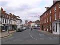
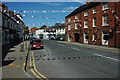
Living in B49 5AX offers a residential experience in a specific postcode area covering a small cluster within the wider Alcester region. This community sits within the Stratford-on-Avon District of Warwickshire, historically located at the junction of the River Alne and River Arrow. The area encompasses approximately 454 m² of land, hosting a population of 1,578 people. You are entering a space defined by its compact scale and established residential nature, distinct from the larger market town of Alcester which lies nearby. The location benefits from historical significance as Alcester was founded by the Romans around AD 47, featuring origins as a walled fort and position on strategic routes like Icknield Street. Today, the neighbourhood maintains a quiet character balanced by proximity to the River Arrow and the River Alne. Residents enjoy the convenience of living close to Roman roads and the town's historic industrial and residential zones. While the area is small, it provides a settled environment where daily life revolves around community proximity and access to local services found just beyond the immediate estate boundaries. The setting appeals to those seeking a grounded living experience in Warwickshire without the density of a major town centre.
- Area Type
- Postcode
- Area Size
- 454 m²
- Population
- 1578
- Population Density
- 116 people/km²
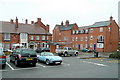
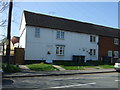
Buying a home in B49 5AX means entering a market defined by high ownership stability and a specific housing type. With 67% of the population being homeowners, the area is firmly rooted in owner-occupied living rather than the rental sector. This high ownership rate indicates that properties tend to remain within local families or are held by long-term residents invested in the community. The predominant accommodation type is houses, meaning you do not need to consider flats or apartments when viewing options in this postcode. The small size of the area, covering only 454 m² of land, limits the total number of households available compared to larger urban districts. This scarcity can influence property values and availability, as the supply of freehold houses is fixed within this cluster. For buyers looking at homes in B49 5AX, the focus is typically on single-family dwellings rather than shared ownership schemes or purpose-built rental blocks. The high percentage of home ownership also suggests a market where sellers are likely keen on moving rather than holding properties as investments, which can streamline the buying process for genuine buyers seeking to settle down.
House Prices in B49 5AX
Showing 1 properties
| Address | Type | Beds | Baths | Last Sale Price | Last Sale Date | |
|---|---|---|---|---|---|---|
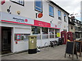
| The Flat Above, Lloyds Bank Plc, Stratford Road, Alcester, B49 5AX | Flat | - | - | - | - |
Energy Efficiency in B49 5AX
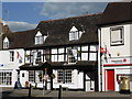
Daily life in B49 5AX is supported by a practical network of amenities within practical reach. Retail needs are met by five nearby stores, including Waitrose Alcester, Tesco Alcester, and Co-op Bidford on. You can access fresh groceries, daily essentials, and standard household goods without a long commute. Travel links are significant, with four railway stations situated nearby. Wilmcote Railway Station, Wootton Wawen Railway Station, and Bearley Railway Station offer rail connections for residents wishing to travel beyond the local village. These stations provide access to broader transportation networks, linking the small residential cluster to Warwickshire and the Midlands. While the area itself is a small residential cluster, the surrounding infrastructure ensures you are not isolated. Schools near B49 5AX are accessible within the wider Alcester district, providing educational options for children living in the housing cluster. The presence of these amenities creates a balanced lifestyle where convenience and connectivity coexist with the quiet nature of village living.
Amenities
Schools
| Rank | School | Type | Entry gender | Ages |
|---|
Explore more schools in this area
Go to Schools tabDemographics
The community in B49 5AX is characterised by a mature and stable population. The median age stands at 47 years, with adults aged between 30 and 64 years representing the most common age range. This demographic profile suggests a neighbourhood dominated by families and individuals in their working and retirement years. Home ownership rates are robust, with 67% of residents owning their properties outright or with a mortgage. Consequently, the area functions primarily as an owner-occupied community rather than a rental market. The predominant ethnic group in the area is White, reflecting a traditional demographic composition found in much of rural Warwickshire. Accommodation types are exclusively houses, indicating a housing stock suited to family life or those preferring detached or semi-detached living arrangements over flats or apartments. The population density averages 116 people per km², confirming that you are purchasing within a low-density environment where properties are spaced further apart than in urban zones. This demographic stability means the area is not subject to rapid tenant turnover, fostering long-term local engagement.
Household Size
Accommodation Type
Tenure
Ethnic Group
Religion
Household Composition
Age
Household Deprivation
NS-SEC
Explore more demographic insights in this area
Go to Demographics tabPlanning
Planning Constraints
- Flood RiskPremium
- Ramsar Wetland SitesPremium
- Area of Outstanding Natural BeautyPremium
- Protected Nature ReservePremium
- Protected WoodlandPremium