Area Overview for B42 1DE
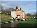
Photos of B42 1DE

Area Information
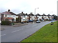
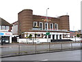
Living in B42 1DE means inhabiting a compact, high-density postcode in Perry Barr, a suburban area of north Birmingham. With a population of 1,472 spread across 2,691 m², the area is densely populated, reflecting a mix of long-standing residential clusters and historical development. Perry Barr itself has roots in the Domesday Book, with its name derived from Old English and Celtic terms for “pear tree” and “hill top.” Today, the area balances modern living with historical echoes, such as the former Birmingham Crematorium and the Odeon cinema. Daily life here is shaped by proximity to rail and metro networks, with five nearby stations including Hamstead and Perry Barr Railway Stations. The community is predominantly middle-aged, with a median age of 47, and a strong focus on homeownership. While the area lacks expansive green spaces, its compact nature ensures amenities like Lidl, Co-op, and Tesco are within practical reach. For buyers, B42 1DE offers a blend of convenience and historical character, though the high population density may influence property availability and local dynamics.
- Area Type
- Postcode
- Area Size
- 2691 m²
- Population
- 1472
- Population Density
- 4837 people/km²
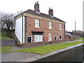
The property market in B42 1DE is characterised by a high rate of homeownership (60%) and a focus on houses rather than flats or apartments. This suggests a community of long-term residents, many of whom may have purchased properties in the area’s historic residential clusters. The compact nature of the postcode—covering just 2,691 m²—means the housing stock is limited, and buyers may need to look beyond immediate surroundings for additional options. The predominance of houses implies a preference for family homes, though the high population density could mean properties are closely spaced. For investors, the area’s small size and existing homeownership rate may indicate a stable market with limited turnover. However, the lack of data on rental properties or recent price trends means potential buyers should consider the area’s suitability for their specific needs, particularly if seeking larger or more varied housing options.
House Prices in B42 1DE
Showing 1 properties
| Address | Type | Beds | Baths | Last Sale Price | Last Sale Date | |
|---|---|---|---|---|---|---|
| Bailey & Mackey Ltd, 15 Baltimore Road, Birmingham, B42 1DE | shop | - | - | - | - |
Energy Efficiency in B42 1DE
The lifestyle in B42 1DE is defined by accessibility to essential amenities within walking or short driving distance. Retail options include Lidl Birmingham, Co-op Walsall, and Tesco Great, providing grocery and daily essentials. The area’s rail and metro stations—such as Hamstead and Handsworth Booth Street—connect residents to broader shopping, dining, and leisure opportunities across Birmingham. While the data does not list parks or recreational spaces, the proximity to historic sites like the Birmingham Crematorium and the former Perry Barr Stadium suggests a mix of cultural and community-focused activities. The compact nature of the postcode means amenities are concentrated, fostering a sense of convenience but potentially limiting space for larger public areas. For residents, the balance between practicality and density shapes daily life, with a focus on efficient access to services and transport links over expansive leisure facilities.
Amenities
Schools
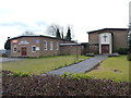
The nearest school to B42 1DE is St Mark’s Catholic Primary School, which serves the area with a primary education offering. The school holds an Ofsted rating of “good,” indicating satisfactory standards of teaching and student outcomes. However, the data does not list any secondary schools or other educational institutions nearby, meaning families may need to look beyond the immediate postcode for comprehensive schooling. This could be a consideration for parents prioritising a full range of educational options. The presence of a single primary school suggests the community is small enough to support a single institution, though it also highlights the need for additional resources or transport links to access higher education. For prospective buyers, the quality of the local school is a key factor, though the absence of secondary options may require further research into nearby districts.
| Rank | School | Type | Entry gender | Ages |
|---|
Explore more schools in this area
Go to Schools tabDemographics
The community in B42 1DE is largely composed of adults aged 30–64, with a median age of 47. Home ownership is strong, at 60%, and the predominant accommodation type is houses, reflecting a settled, family-oriented demographic. The majority of residents identify as White, though specific diversity metrics are not provided. The high population density—546,914 people per km²—suggests a compact, closely knit community, though this may also contribute to a sense of overcrowding in shared spaces. The age profile indicates a mature population, which could influence local services and amenities. For instance, the presence of St Mark’s Catholic Primary School caters to younger families, but secondary education options are not listed in the data. The area’s demographics suggest a stable, long-term resident base, though the lack of detailed diversity statistics means broader social dynamics remain unexplored.
Household Size
Accommodation Type
Tenure
Ethnic Group
Religion
Household Composition
Age
Household Deprivation
NS-SEC
Explore more demographic insights in this area
Go to Demographics tabPlanning
Planning Constraints
- Flood RiskPremium
- Ramsar Wetland SitesPremium
- Area of Outstanding Natural BeautyPremium
- Protected Nature ReservePremium
- Protected WoodlandPremium